
You can’t have an outdoors blog in Arkansas without giving some serious attention to Petit Jean State Park. It is Arkansas’ first state park. It’s also one of my go-to spots when I want a spur-of-the-moment, close to home day hike. It’s great because there are so many options there. Whether you want waterfalls, vista views, caves, or cool rock formations, Petit Jean has it all. And that’s just the hiking part. There is also a lake, car museum, full hookup campgrounds, cabins, restaurant, and Mather Lodge.
Trying to fit it all into one post will make for a really long read. So this will be another blog series. Part One – You know it has to be the flagship trail. One of the most popular trails in the state. The ever-popular…
Cedar Falls Trail
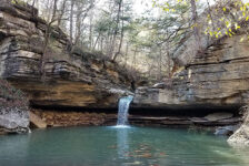
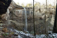
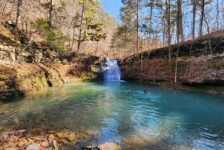
Petit Jean State Park – Cedar Falls Trail is by far one of the most heavily hiked trails in Arkansas. Most people that do any hiking at all have done this trail and have their own pics of the falls. And for good reason. When there’s a decent amount of water, Cedar Falls is one of the largest, most impressive waterfalls in Arkansas.
Directions
Petit Jean State Park is a few miles southwest of Morrilton right off Hwy 154. Or approx 6 miles north of Adona off Hwy 10 to Hwy 324/155 if you’re coming from the south. Google knows all about this one, so not much direction is needed here. Type the park in your phone map and it will get you there. Once there, stop by the visitor center and pick up a park and trail map. For Cedar Falls, just go to Mather Lodge and park (good luck on a busy day). The trail head will be on the back side of the lodge where people will be enjoying the view of the gorge.
What to expect
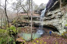
Well, obviously there’s a 95-foot waterfall at the end. And if that’s all you want to see, there is a lookout vista for that (also on the park map). But you don’t want that. You’re a hiker. You want the whole experience. This is an out-and-back trail, just about a mile each way. Most of the trail is in the bottom of the canyon following alongside Cedar Creek. The hardest part is the section getting to/from the top to the bottom of the canyon. The trail is rocky and steep with a lot of switchbacks until you get to the canyon floor. But it is a well-constructed trail that is suitable for most hiking levels. However, I can’t recommend this trail for anyone with heart or mobility issues. Coming back up out of the canyon is tiring and can be a challenge for some.
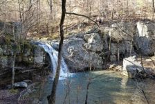
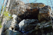
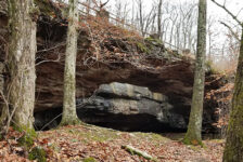
Once reaching the canyon floor and crossing the bridge over Cedar Creek, take the trail to the right. (left is the Canyon Trail – another post in this series). The trail will follow along the creek and take you right to the falls. It is clean, well-marked, and there is no chance of getting lost. If in doubt, follow the crowd. When the trail reaches the falls area, it basically becomes a huge pile of boulders in and around the creek and falls pool. It opens up into a giant grotto. You can go to the left, or cross the creek and go around the right side. The right side is a little tricky, but if you explore enough, you’ll find the way to go over, around, and even UNDER the boulders to get to the falls.
Pics From the Trail:


Plan your trip
Give yourself a couple of hours to hike Cedar Falls trail. Due to all the large rocks (some slick) and steep ascent, I recommend good hiking or trail shoes. At a minimum, tennis shoes, or hiking sandals. You might consider carrying some water shoes or flip flops for wading around the falls. Cell phone service is spotty throughout the park, but you’re never too far away from a cell signal. If you bring food for lunch, there are plenty of picnic spots for that. If you don’t, there is snack food and drinks at the visitor center. There is also a full-service restaurant at Mather Lodge. The restaurant is pretty good, by the way.
There are enough things to do in the park to fill a weekend, and plenty of options for spending the night. Definitely call ahead to check availability on the lodge or cabins. Camp sites are almost always available. But during busy times it’s probably a good idea to call ahead to check on those as well.
Here are some pics from the falls. Hope you like these. If you get a chance to visit, please remember this area gets a lot of traffic. Help take care of it by taking nothing but pictures, and leaving nothing but footprints. Thanks!


Mal
Love petit jean! Have you visited the farmers market on Winrock right by the park? Such a neat place!
Scott Hallmark
Hi Mal. No, I haven’t been to the farmer’s market. I’ll have to check that out next time!