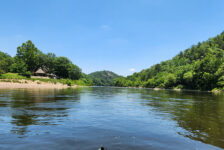
Welcome to Part Two of the Petit Jean State Park hiking series, the Seven Hollows Trail. Petit Jean is Arkansas’ first state park. It’s also one of my go-to spots when I want a spur-of-the-moment, close to home day hike. It’s great because there are so many options there. Whether you want waterfalls, vista views, caves, or cool rock formations, Petit Jean has it all. If you missed Part One, I covered the most popular hike in the park. That would the Cedar Falls Trail, with it’s massive grotto and 90-ft Waterfall.
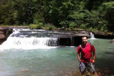
In my opinion, the Seven Hollows trail is just as impressive in it’s own way. There is actually MORE to see. It also has a grotto and waterfall. But in addition to that, you’ll see lots of impressive bluffs, a natural bridge, several caves, and multiple creek crossings. There are also a lot really cool rock formations, including some “turtle rocks” that are found in other areas of the park. It’s the longest trail in the park, so maybe that’s why it’s not as popular. I only recently hiked it for the first time myself. And I can’t believe I waited so long to do it!
Directions
Petit Jean State Park is a few miles southwest of Morrilton right off Hwy 154. Or approx 6 miles north of Adona off Hwy 10 to Hwy 324/155 if you’re coming from the south. Google knows all about this one, so not much direction is needed here. Type the park in your phone map and it will get you there. Once there, stop by the visitor center and pick up a park and trail map. Driving south from the visitor center, Seven Hollows will be the last trail you find on the left.
Natural Bridge
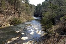
Where the trail coming from the parking lot splits into the loop, we turned left and did the loop clock-wise. As we made our way down the hill, it didn’t take long to start seeing large boulders. Those boulders eventually turned into large bluff that towered high above the trail. We passed by a couple of small caves, and then out of nowhere walked right up on the natural bridge. That part was really impressive. Not far after that, there is another fork in the trail. You can stay to the left or follow the trail across the creek where it keeps going. You will want to go right and cross the creek here to stay on the loop.


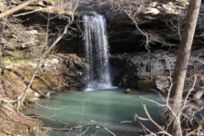
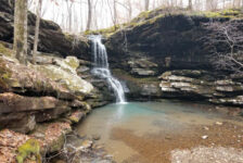
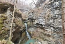
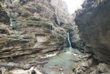
The Grotto
Once you get to the side trail to the grotto, I definitely recommend taking it. It’s not even the .25 miles it says on the sign. The grotto is not as large as the Cedar Falls grotto, but it’s pretty good size. It’s a great spot to take a break and rest or have lunch. There was a lot of water trickling in the creeks and on parts of the trail that day. So there was also a decent amount in the falls at the grotto.


Turtle Rocks
Immediately after leaving the grotto, the main trail makes its way uphill and over several sections of turtle rocks. These are the same kind of rock formations that can be seen on the Turtle Rocks trail that I’ll write a post about later. If you have never seen these, they look exactly like turtle shells. And they form sections of this trail that you actually walk on. I recommend visiting the Turtle Rocks trail to read about how these are formed.
After the turtle rocks, the trail passes through a pine thicket and then on to more wooded cliffs. There are more cool rock formations here along with a couple more creek crossings. Once again the trail winds its way through some corridors of high bluffs and then back up the hill to the parking lot.
Plan Your Trip
The sign says this is about a 4-hour hike. We finished the hike in 2.5 hours and were not moving fast. We were not in a hurry and even took a break at the grotto. There are a few spots with some large rocks to get over and around. And with the creek crossings, and the ups and downs of the trail, I recommend good hiking or trail shoes. At a minimum, tennis shoes, or hiking sandals – something to give your feet a solid grip. Do not hike this trail without carrying some water, especially in hot weather. There are some sections with no shade that will get very hot. And with at least one mile of the hike uphill, water will be important. Cell phone service is spotty throughout the park, but you’re never too far away from a cell signal. As I mentioned in the last post, there is snack food and drinks at the visitor center. There is also a full-service restaurant at Mather Lodge. We had lunch there after the hike and the burgers are outstanding. There are enough things to do in the park to fill a weekend, and plenty of options for spending the night. Definitely call ahead to check availability on the lodge or cabins. Camp sites are almost always available. But during busy times it’s probably a good idea to call ahead to check on those as well.
Here are some pics from Seven Hollows. I hope you like these. If you get a chance to visit, please remember this park gets a lot of visitors. Help take care of it by taking nothing but pictures, and leaving nothing but footprints. Thanks!