Welcome to Part Four of the Petit Jean State Park hiking series, the Cedar Creek Trail. Petit Jean is Arkansas’ first state park. It’s also one of my go-to spots when I want a spur-of-the-moment, close to home day hike. It’s great because there are so many options there. Whether you want waterfalls, vista views, caves, or cool rock formations, Petit Jean has it all. If you missed Part One, I covered the most popular hike in the park. That would the Cedar Falls Trail, with it’s massive grotto and 90-ft Waterfall.
Cedar Creek is what actually creates Cedar Falls. So the trail explores areas above the falls on both sides of the creek. This is a great hike to do if you want to avoid the crowds at the Falls. Or if you’ve done the other trails and want to see something different. It also has some small falls of its own. And there is access to the Boy Scout Trail, which has a nice view of the Cedar Falls from the other side of the canyon.
Directions
Petit Jean State Park is a few miles southwest of Morrilton right off Hwy 154. Or approx 6 miles north of Adona off Hwy 10 to Hwy 324/155 if you’re coming from the south. Google knows all about this one, so not much direction is needed here. Type the park in your phone map and it will get you there. Once there, stop by the visitor center and pick up a park and trail map. Driving south from the visitor center, look for the Pioneer Cabin on the right. The Cedar Creek loop starts and finishes there.
What to Expect
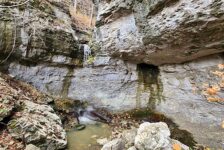
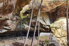
The Cedar Creek Trail is a 1.25 mile loop that is fairly easy to walk. I really like this trail a lot because it has a little bit of everything. From the Pioneer Cabin you descend down a boulder path to the creek. From there, you can access part of the Boy Scout Trail leading uphill to the Cedar Falls observation deck. This trail has some really great canyon views. Or you can stay on the Cedar Creek loop and see some cool rock formations and small caves.
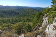
There is a bridge crossing to the other side of the creek. Once across, you again have the option to turn left and take another section of the Boy Scout trail up another hill. This trail eventually leads to the Turtle Rocks/Indian Cave area, and I highly recommend taking it. Because on the way, you’ll see awesome rock formations, bluffs, and views of the canyon. And if you explore enough, you’ll find a vista where you can view Cedar Falls from a perspective many people don’t see. (see this post for more on that, and video of Cedar Falls)
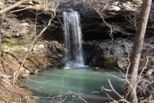
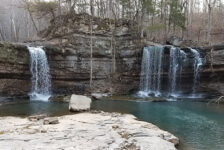
Opting instead to go right will keep you on the Cedar Creek Trail loop. There you’ll see some really great views up and down Cedar Creek, bluffs and rock formations. And when there’s enough water, there are some small falls close to the end:
Another bridge will bring you back across the creek and eventually up the slight hill to the cabin. For the most part I consider this to be a pretty easy-to-moderate hike. There are only a few steep parts and they’re not long. The trail is well-marked, clean, and easy to navigate.