
Original article from March 14, 2020 edited/rewritten on November 27,2024.
One of my favorite things about hiking is often the drive to get the trailhead. There is often a lot of scenery and cool things to see on those dirt roads out there. Sometimes I enjoy a day of driving backroads through the wilderness with very little hiking at all. On some of those cold, wet Winter days, or days I don’t feel up for a tough hike, it’s a good way to still get out and enjoy nature. One of my favorite spots to do this is near the Albert Pike area with a stop at Little Missouri Falls in the Ouachitas.
With miles and miles of backroads in this area, visiting Little Missouri Falls is just the tip of the iceberg. There are so many areas to hike and things to see. But for anyone that’s never visited the area, a drive along Crooked Creek to see Crooked Creek Falls and Little Missouri Falls is a must.
Quick Glance
Distance: Approximately .3 miles out and back
Difficulty: Easy
Little Missouri Falls Parking: 34.422747, -93.919685
Crooked Creek Falls Parking: 34.426988, -93.885843
(Copy/Paste Coordinates into GPS or Google Maps search bar)
Directions
Little Missouri Falls is located about 32 miles northwest of Glenwood and about 30 miles southeast of Mena. It is south of Hwy 8 and north of Hwy 84 on Mine Creek Rd (aka Nfw 539). It is 8.4 miles northwest of Albert Pike Recreation Area. There are so many ways to get to it from many different directions, it would take all day to write them all. But it is well-known enough that it will pull up on a Google Maps search. Map yourself to the points on the map below, and you’ll drive right to it.
What to Expect
Hike Along Crooked Creek
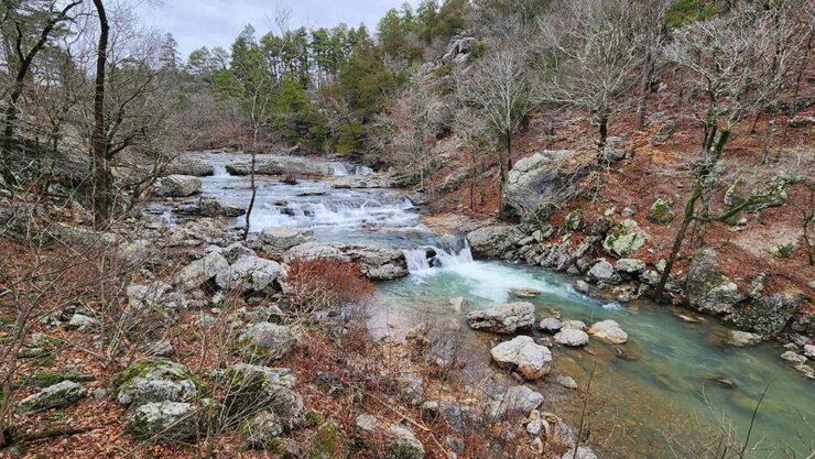
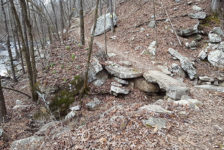
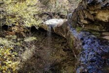
Driving in from Caddo Gap or Norman, you’ll turn onto Albert Pike Rd. Eventually Albert Pike Rd will run alongside Crooked Creek, crossing it several times. This stretch of Albert Pike Rd is absolutely gorgeous when Crooked Creek is flowing strong. In some places the road sits high above Crooked Creek, with great views of the shoals, waterfalls, and rock formations. In other spots, the road dips down to creek level There are several places to park and hike parts of the creek and get some fantastic photos. I didn’t see any official trails, but there were some faint volunteer trails here and there. A person could easily spend a day hiking along Crooked Creek.


Crooked Creek Falls
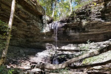
Much like Falling Water Falls in the Richland Creek area of the Ozarks, it doesn’t get much easier to see a waterfall than this. Continuing along Albert Pike Rd, plug the coordinates above into your Google map or GPS, and it’s hard to miss. Crooked Creek Falls is visible from the road, and a short walk down an easy embankment to creekside. At 16 feet high, Crooked Creek Falls is not all that tall. But during the wet season, this twisting cascade dumps out a powerful volume of water. Being so close to the road, this is a great spot to plant a chair or hang a hammock and have lunch.
Little Missouri Falls
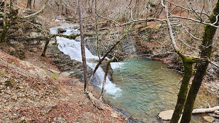
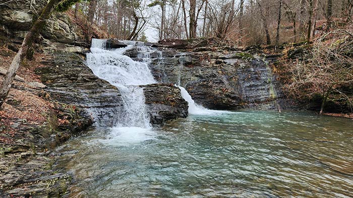
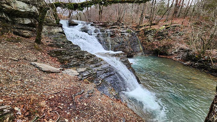
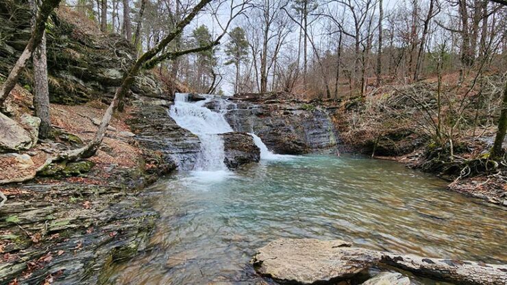
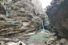
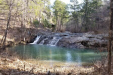
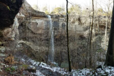
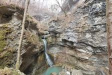
Little Missouri Falls in the Ouachitas is one of the crown jewels of the Eagle Rock Loop. This place is incredible. In the summer, it looks like the kind of place you might see on a tropical island or something. There is not one large, or high waterfall here. This is a series of rock shelves and small waterfalls that cascade like stairs down a hill. Each shelf empties into a small pool that empties into another. The stream finally dumps into a larger pool at the bottom before the river heads out into the forest. The trail only goes down one side of the falls. The other side is mostly booked in with bluffs, boulders, and brush. There are several spots along the trail to access the water and wade around the falls.
The first time I visited here, I was surprised to find how close the falls are to the parking area. I was expecting more of a hike, but no, the falls are only a couple hundred feet away. I made my way down the trail and started exploring the falls. It didn’t take long to realize that I was not prepared for this warm weather visit. The first thing I wish I had brought was water shoes. I waded around the falls barefoot, but water shoes would have been so much better. I had my lunch on a giant rock next to the falls and realized the next thing that was missing – my hammock! This would be a great place to hang a hammock and chill for a while. Lastly, I was a little jealous of the people cooling off in the swimming hole at the bottom of the falls. I wished that I had brought a towel and a change of clothes for swimming. My second visit was in Winter, and I had NO desire to wade into that cold water! But with no tree leaves to hide the surrounding bluffs, I think the pictures were better. And the emerald green waters really popped against a backdrop of winter-brown bluffs and overcast sky.
Hiking Little Missouri Falls in the Ouachitas
As I mentioned, you can drive straight to the falls. But there are trails here you can hike. The trailhead for the Little Missouri Trail starts in the parking lot. It runs 11.7 miles to Albert Pike Recreation Area. The Little Missouri Trail is also a popular section of the 28-mile Eagle Rock Loop trail. I have not hiked these yet. But I hear they are great trails with tons of scenery.
Plan Your Trip
No matter which season you visit Little Missouri Falls in the Ouachitas, it’s best to go after there’s been some rain in the area. I would like to return when it’s warm enough to swim, but still plenty of water. I’m thinking early May to early June. It is not a quick, easy drive from most places in the state. Give yourself plenty of time to get there, and plan on spending some time driving on gravel roads. A 4-wheel-drive is not needed, but these roads are not friendly for sports cars or motorcycles.
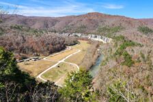
The area is pretty remote, so don’t plan on having cell service there. If you plan to do other hikes in the area such as Winding Stairs, download or print trail maps before you go. Take food and drinks if you’re spending the day because there is nothing out there within 30-40 minutes. A vault bathroom (pit toilet) is available next to the parking area. There is a nicer restroom at the Albert Pike Rec area, but it may or may not be locked. The small community of Langley lies to the southeast, and has one country store with some food and drinks if you need it. Be prepared to pack out any trash you might have and leave no trace while visiting this area.
This is a wonderful area to spend a weekend if you love to hike or explore wilderness backroads. Camping is currently not allowed at Albert Pike Recreation Area (though it might soon be back). However, there are tons of primitive campsites to be found driving this labyrinth of backroads though the Ouachita wilderness. Many are located along beautiful streams or high atop mountains. Camping is also allowed along the Eagle Rock Loop trail. If camping is not your thing, there are lots of cabins for rent in the area. Check out our friends at Find A Place Arkansas to start your cabin search.


Hollie
My favorite place we have visited