
We have reached that part of the Summer where floatable rivers can be a little hard to find. Outside of the lower Buffalo and a few others, most of the popular rivers get too low without any rain. That leaves us with the spring-fed rivers of northern AR and southern MO, and several dam-fed rivers flowing from lakes. Examples of these would be the Little Red, lower Caddo and lower Ouachita, which I have written about. And last weekend, I learned all about floating the Little Missouri from the Narrows Dam at Lake Greeson.
Floatable rivers may be a little hard to find this time of year, and whitewater is even harder. But when the Narrows Dam starts releasing water into the Little Missouri River, buckle up and hang on! No, I don’t mean crazy rafting whitewater like you might see in Colorado. It’s not that extreme. But this is no beginners float. The rapids may not be technical or difficult., but there’s a LOT of water moving really fast through there. To learn about this float, I met up with members of the Arkansas Yakking and Kayaking Facebook group. These were some great, fun folks with plenty of experience running this stretch of river. And now…my friends…I’m going share that with you.
Directions
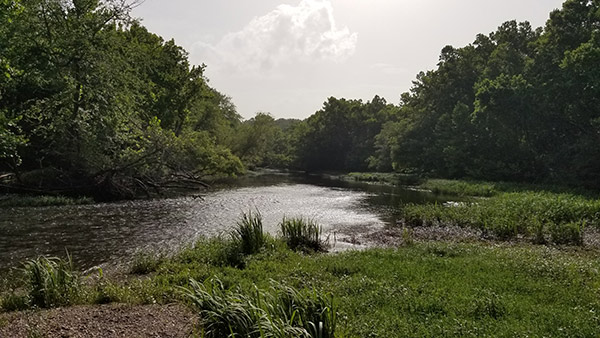
The Narrows Dam is on the south side of Lake Greeson near Murfreesboro in southwest Arkansas. The put-in point is at Riverside Picnic area just below the dam. For take-out, there are several roads that lead to random access areas on the river. I have mapped the 5-mile and 10-mile public access points on the Google map below.
What to Expect
The 10-mile float to Hwy 27 is really a tale of two floats. The second 5 miles is very different from the first 5 miles. They can be done individually or together, starting or finishing at any of he access points.
First Half
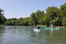
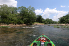
The first 5 miles of this float is really the fast and fun part. American Whitewater rates this as class II rapids. I think that’s a bit deceiving. I’ve seen other runs they rate as class II that are much easier than this one. Maybe it’s because the rapids on this run are not technical or difficult. But there is so much water moving really fast through it, that it feels a bit more extreme. There are no big drops or tricky curves. But there are some big waves. It’s mostly wave trains and lots of churning water, as you can see in the video below. I really can’t recommend the first half of this float for beginners. And even experience paddlers need to wear their PFD for it.
Most of the paddlers on this float were using sit-on-tops or sit-in kayaks with spray skirts. I floated in my Old Town sit-in, which has a very large opening and no skirt. I was concerned that I might take on too much water. My kayak did take on quite a bit of water in the larger rapids, but nothing to worry about. However, if I had flipped and filled my kayak with water, I would have been in trouble. For most of the 5 miles, the banks are steep and overgrown with brush and trees. There are very few places to pull over and empty out. For that reason, I highly recommend a sit-on-top or a skirted sit-in kayak for this float. And you need to be able to get on your kayak from a floating position.
Second Half
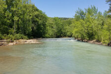
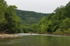
There are just a couple of the fast, fun rapids at the very beginning of the second half of this float. But for most of miles 5-10, it is more of a lazy river float. There’s a little bit of class I action, and a lot more gravel bars. We did run into a few strainers along the way. One of which got cut up and cleared by a couple members of the group. But one was not as cooperative and gave us a scare. One of our paddlers had to bail from her whitewater kayak when she got stuck in a tree upside down. She was OK, but it was scary for a minute. So watch out, and portage around these!
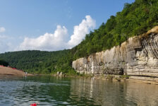
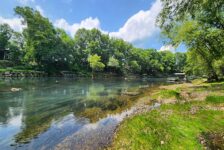
There are some pretty spots on this half of the float, along with some very nice riverfront homes. But the last mile….I’m just gonna be honest…it’s ugly. It has muddy banks, looks pretty swampy, and kind of stinks. The last mile is pretty much all flat water with no current. I paddled hard through this because it just sucked and I was ready to be done. Don’t get me wrong – it’s not a deal breaker and wouldn’t keep me from doing this float again. But I want my readers to know exactly what to expect.


Plan Your Trip
Timing Is Critical
First and foremost, it’s important to know that this river is not runnable unless the Narrows Dam is generating (releasing water). So you can’t just show up at anytime, and start floating. It takes some planning. The Southwest Electric Power website posts Dam generation schedule. But I wouldn’t trust it completely. It said 3:00 on the day we floated, but they actually started closer to 2:00. I’d say be at Riverside Picnic area ready to float by 1:00. You’ll hear the siren when they begin generating.
Once you see the water begin to rise, you’ll be tempted to hop on the river and take off. Resist this urge! If you jump in too soon, you’ll outrun the water and be left dragging in low water until the current catches up. In fact, we had to stop a couple of times to let the water catch up with us. Give it about 45 minutes after the siren, then go.
Renting and Shuttling
Another important thing to know is, be prepared to take your own boat and self-shuttle. I never saw any outfitters at the put-in or take-out points. I never saw any on the highways or in town between those points either. A quick Google search for outfitters in the area produced no good results. So you’ll need your own boat, and will need to drop a vehicle at one of the 2 access points in my map above. If I’m wrong about this, please correct me in the comments area below.
There is not a cell signal for most of the float, including at Riverside Picnic Area. So meeting up and coordinating with a group might be more easily done in Murfreesboro. That said, the Riverside Picnic Area is very nice. They do have nice clean bathrooms there. After running paddlers back up to their cars, I used it to change into dry clothes for my ride home. There are dining options in Murfreesboro for before or after your float. Don’t forget to pack some snacks and drinks for the river. Also be ready to pack out your own trash and leave no trace. Again, please have at least some basic paddling skills under your belt and some knowledge of handling swift water situations before doing this float. Be safe out there and enjoy the ride!


Gayle M Powell
I have an inflatable sit in kayak. Would that work for this area?
Scott Hallmark
Hi Gayle. I’m sorry, I missed your question before and just now saw it. But yes, an inflatable will work IF it is a high-quality inflatable and you are not worried about punctures. One of the guys in the group I was floating with the day I did the float was in an inflatable kayak. But it was a pretty expensive one that is hard to puncture.
Ballard
Hi Scott, Thanks for the details on the lower Missouri. Quick question, you mentioned that it started to smell bad further down river, any idea what the smell was coming from? Is the river a mud bottom or rock bottom?
Scott Hallmark
Hi! It’s been a while, so I don’t remember exactly what the bad smell was. But I’m pretty sure it was either a dead animal or just the smell of stinky mud. The river mostly has a rocky bottom. But close to the end, it’s mud.