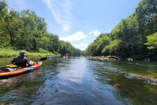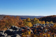
Folks, we have had some really good (and rare) late-summer floating opportunities this year. I have written several times about taking advantage of the prime floating conditions of Spring and early Summer. One of the spots this really applies to is the run from Wolf Pen to Byrd’s on the Mulberry River. I missed my chance early in the summer. But thanks to all the rain from the hurricanes, I got a rare late-summer chance to float this section of river on Labor Day weekend.
I have stated in a previous article that High Bank to Byrd’s was one of my favorite floats in the state. Well, I’m adding 4 miles to that run and saying Wolf Pen to Byrd’s is now one of my favorites! Not only did we catch it when it was runnable – it was actually high. If you’re lucky enough to catch the Mulberry like this, you’re in for a fast and fun ride. No paddling, just steer!
Directions
This is one of the easiest rivers in Arkansas to access. The access points for this float are about 45 minutes north of the Ozark exit from I-40. From Hwy 23, aka “The Pig Trail”, at the community of Cass, go east along Cass-Oark Rd (Hwy 215). You will see signs for Byrd’s Adventure Center and Wolf Pen access point. These points are mapped out for you below:
What to Expect
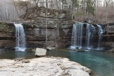
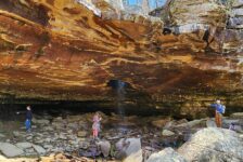
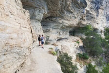
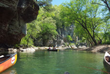
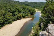
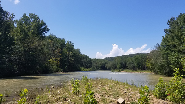
In my High Bank to Byrd’s article, I wrote all about the emerald green water and the scenic beauty of the river. So if you haven’t read that, you should because High Bank to Byrd’s is the second half of this float. When floating Wolf Pen to Byrd’s on the Mulberry River, you’ll see all that plus an extra 4 miles of the same. But it’s a fun 4 miles, with some fun rapids, a rope swing, and usually less people.
The total distance on this float is 8 miles. A great thing about the Mulberry is that all the access points are either 2 or 4 river miles apart. I don’t know if they planned it that way, but it makes it easy to judge how far you’ve paddled. On this particular float, the water level was 4-4.5 feet, and it was rolling pretty fast. So we made it to Byrd’s in around 4-5 hours, and that was with plenty of stops. On a day with slower water, I would say give yourself 5-6 hours for this float.


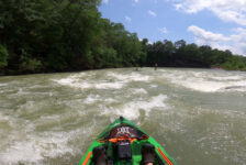
Class II-III Rapids
I always had it in my mind that Wolf Pen to High Bank would be pretty sketchy as far as rapids go. But that really wasn’t the case. In fact, the more sketchy rapids are found between High Bank and Byrd’s. All of these can be seen in the video below. My battery died and I missed filming the best set of rapids, which lies right after the High Bank put-in. But you can see those in the the video found in the High Bank to Byrd’s article. American Whitewater rates this section as Class II+. So at lower water levels, this is mostly class II. But at levels around 4 ft or higher, I would say some of the rapids are closer to class III. I would have been better off with a sit-on-top, as my wide-open sit-in kayak took on a lot of water that day. If fact, it caused me to flip my kayak for the first time ever! (Yes, I left that in video…around the 28:30 mark)
Plan Your Trip
One of my favorite things about the Mulberry is how easily accessible it is. All the access points above Turner Bend are off Cass-Oark Rd, which hugs the river running east and west. The access points are easy to get in and out with no long gravel roads to travel. They may get a little crowded sometimes. So if you’re self-shuttling and leaving a car, better get there fairly early. That’s another thing – this river is super easy to self-shuttle. You can drive from Wolf Pen to Turner Bend in less than 30 minutes. And there are a lot of convenient access points in between. This leaves lots of options for customizing the length of float you want to do.Wolf Pen to Byrd’s is 10-15 minutes. For a small parking fee, you can leave a car at either of the outfitters if you end your float there. Wolf Pen and Redding access areas cost $3 per car. If you cannot self-shuttle, the good folks at the outfitters can get you where you want to go.
Accomodations
There are several options for spending the night. Byrd’s, Turner Bend, Wolf Pen, and Redding Campground all offer tent camping sites with various options. Turner Bend has a few cabins for rent. And Byrd’s offers RV/Camper sites – some with full water and electric hookups. Food options are plenty too. Turner Bend Store has a great deli. Byrd’s has a full-service riverside restaurant. And just down the road in Oark, the Oark Cafe has some of the best burgers and homemade pies in the state.
Floating
When floating Wolf Pen to Byrd’s on the Mulberry, it’s best to check the water levels on American Whitewater. The river sections in green on their site, are good to go. If you’re still not sure, call Byrd’s or Turner Bend Store to get real-time info on the river conditions. If you are renting a kayak or canoe, it’s best to call the outfitter ahead of time anyway to reserve. Speaking of calling, it’s hard to get a cell signal anywhere on Cass Oark Rd. So if you’re meeting or coordinating with others, you’ll need to get close to the Turner Bend Store for a signal.
If you are a first time floater, check our gear list for all you’ll need. Remember, no glass of any kind on the river, and be sure to keep your trash in a bag. This is a really special area. So be sure to leave no trace, and keep this river beautiful. Enjoy the float!