There has been a surge of new mountain bike trails constructed all over the state in the past few years. New trails are being finished faster than I can keep up with them. Not only is the quantity of trails in Arkansas increasing, but so is the quality. For years, I was used to riding on trails that basically amounted to hiking trails you could ride bikes on. But these new trails are professionally constructed specifically for mountain biking. The mountain bike trails at Mt. Nebo State Park are a great example. They are part of the Arkansas State Parks Monument trails collection, which you can read more about here.
Much like the new trails around Bentonville, Hot Springs, and Pinnacle Mountain, these new trails make mountain biking more fun. That’s because they are designed for biking. A lot of thought and planning goes into laying out a MTB trail in a way that keeps the ride flowing. Designing it so that inclines are preceded by a decline to give the rider enough speed to get up the hill. Making use of switchbacks to keep the uphill climbs from being too steep. The construction crews have done amazing work to remove large rocks and pack the dirt to make the ride smoother. They have created embankments on tight turns, and built jumps and obstacles for advanced riders. There are strategically-placed and ride-able rock gardens that keep the trail from getting muddy or eroding. You’ll see all these features on the mountain bike trails at Mt. Nebo.
Directions
Mt. Nebo is located about 20 minutes south of I-40, near Dardanelle, halfway between Little Rock and Ft. Smith. Use the map below to navigate to the park. Once you get there, look for one of several parking areas near the bike trails, marked with a yellow “Monument Trails” sign. Which one you choose depends on which trails you want to ride.
What to Expect
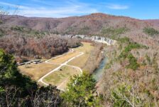
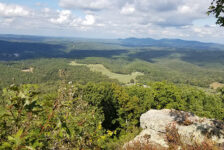
Until the past couple years, Mt. Nebo State Park has been primarily a hiking park with some really nice hiking trails. You can read about my favorite Mt. Nebo hiking trail here. It’s also a popular spot with hang-gliders, and if you’re lucky you just might get to see one take off from Sunrise Point. But the main thing that keeps people coming back to Mt. Nebo has got to be the spectacular views. Mt. Nebo is a steep mountain that rises high above the Arkansas River Valley to the north and east. To the south and west, you’ll find views of the Ouachita Mountain range. People camp out and rent cabins here just so they can enjoy the view for days at a time.
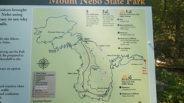
So now that I’ve painted a picture in your head, imagine riding professionally-built mountain bike trails all throughout this place! As far as the trails go, there is a little something for everyone. Trails range from green (beginner/easy) to blue (intermediate) to black (difficult). Even the easy trails have some fun things built in as options for advanced riders. Most of them are single track, with a few segments of gravel road (Bench Trail). The trails have really great flow for the most part, with only a few of them having any long uphill climbs. Below is a list of all the mountain bike trails at Mt. Nebo.
Mt. Nebo MTB Trails
- Three C’s – Green (Beginner) – 1.8 mi.(one way)
- The Bench Trail – Green (Beginner) – 3.6 mi.
- Miller’s Goat – Blue (Intermediate) – 5.3 mi. (this trail has the best views)
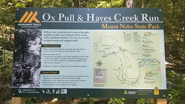
- Ox Pull – Blue (Intermediate) – 1.7 mi. (uphill)
- Hayes Creek Run – Blue (Intermediate) – 2.1 mi. (downhill from Ox Pull)
- Sunrise Loop – Blue (Intermediate)- 1.0 mi. (one way. connects Sunrise Point to Miller’s Goat)
- Lizard Tail – Black (Difficult) – 1.9 mi.
- Chickalah Loop Trail: DH – Black (Difficult) – 2.3 mi. (connects Miller’s Goat to Chickalah Valley Loop)
- Chickalah Valley Loop Trail – Black (Difficult) – 4.8 mi.
When you arrive, expect to be a little overwhelmed with the options and not really sure where to start. It can be hard to figure out which trail is best for you. That’s why you need to download the MTB Project mobile app. It shows all the trails on a map. When you tap on each one, it gives you all the details such as the length, difficulty, ascending feet and descending feet. It tracks you with GPS and shows you your location on the trail at all times. I have ridden two of the trails so far, The Three C’s trail and Miller’s Goat trail. Both of these were pretty fast and flowing single track. Here is some video for each one:
Plan Your Trip
Bring plenty of water, especially in the summer. The visitor center has some snacks and drinks if you need them, and nice bathrooms. Cell service is good here, which is handy for the MTB Project app. Make sure you download that because you are going to need it. The visitor center has maps, but the MTB Project app is way better.
Mt. Nebo is a good place to spend a day, or make a whole weekend out of it. They have a nice campground with bathrooms and showers. Campers over 24 feet are not allowed. They will not make it up all the switchbacks. The park also has some great cabins with incredible views along the Rim Trail. My top recommendation here is to spend at least one night. Make it a point to get up early to see the sun come up at Sunrise Point. Equally beautiful is to watch it go down at Sunset Point. These will be among some of the best pictures you’ll take in Arkansas.
If you go to ride the mountain bike trails at Mt. Nebo State Park, please help take care of it. Remember to leave no trace by taking nothing but pictures and leaving nothing but footprints. Be safe out there and enjoy the ride!


