
I continue to be blown away by the natural beauty in our state. Just when I think I’ve seen the prettiest hike in Arkansas, I eventually go on another one that changes my mind. The hike to Winding Stairs on the Eagle Rock Loop Trail in the Ouachitas is the latest one. I’ll admit that I have not given enough attention to the Ouachita Mountain region so far. Sometimes I get in the habit of heading straight to the Ozarks for hiking waterfalls and paddling rivers. But there are areas of the Ouachitas that are just as great and in my opinion, very underrated. This area around the Eagle Rock Loop is right up there with some of the best spots in the Ozarks.
Many people have gotten confused and lost trying to follow this trail. Unless you download a map, it can be easy to get off the trail and go the wrong way. My first trip there was unplanned, so I didn’t download a map before I went. If you wait till you get there, it’s too late. There is no cell signal there to pull up the trail on the AllTrails or Hiking Project apps. Lesson learned. This time around, I screenshot all the sections of the trail that I needed. I also brought along my buddy David, who has hiked the Eagle Rock Loop Trail. If you plan to do this hike, keep reading for all the details. And be sure to watch the video further below where we walk you through each turn and water crossing along the way.
Quick Glance
Distance: Approximately 4.5 miles out and back
Difficulty: Moderate
Blaylock Creek Parking Area: 34.36609, -93.90199
Blaylock Creek crossing: 34.36370, -93.90168
Little MO River crossing: 34.35517, -93.91053
Winding Stairs: 34.35152, -93.90978
(Copy/Paste Coordinates into GPS or Google Maps search bar)
Directions
The Eagle Rock Loop Trail is located in the Ouachita Mountain region about halfway between Glenwood and Mena. There are multiple places to access the Eagle Rock Loop Trail, and different ways to get to Winding Stairs. But for this particular hike and route, use the map below to navigate to Albert Pike Rec Area near Langley.
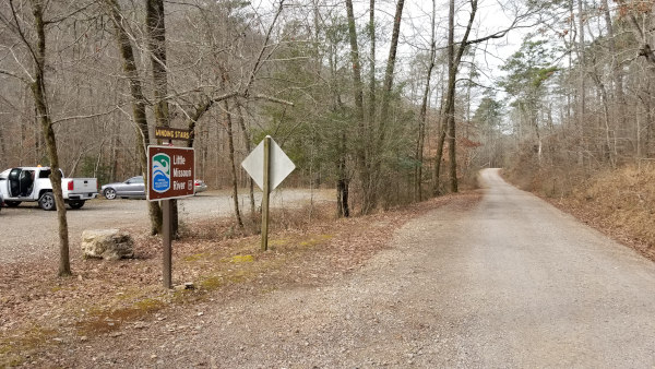
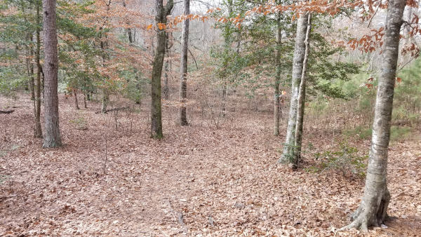
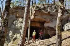
Once reaching the Albert Pike Rec Area, cross over the concrete bridge. Proceed straight past the restrooms up the hill along the busted up paved road, which will turn into dirt and gravel. Follow this road until you see Winding Stairs parking area on the left, pictured below.
What to Expect
I’ve hiked to a lot of beautiful places in Arkansas and have seen some jaw-dropping scenery. The hike to Winding Stairs is among some of the best I’ve seen. This place was so awesome I didn’t want to leave. I decided right then I’ll be coming back on an overnight hike to spend the night sometime. And I can’t wait to hike the entire Eagle Rock Loop. Also, after seeing quite a bit of the Little Missouri River, I’m ready to float it. It will be at the top of my list in the Spring. I’ll have to keep an eye on the water levels and be ready to go when it’s just right. From what I understand, it doesn’t stay floatable for long periods of time.
The Trail
Starting at the Winding Stairs parking area and following the AllTrails route, this is a 4.5-mile out and back hike. It is a clean, heavily-trafficked, and well-marked trail rated as moderate. The trail winds along the sides of a couple of mountains in some parts and along the Little Missouri in other parts. There are some elevation changes along the way but nothing too strenuous. We took our time and were able to reach the Winding Stairs area in about an hour and a half. So the out-and-back round-trip can be done in around 3 hours, possibly less. But please….give yourself 4-5 hours to really enjoy it.
Scenery and Features
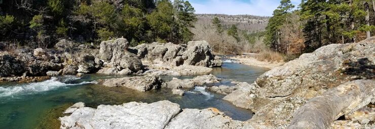
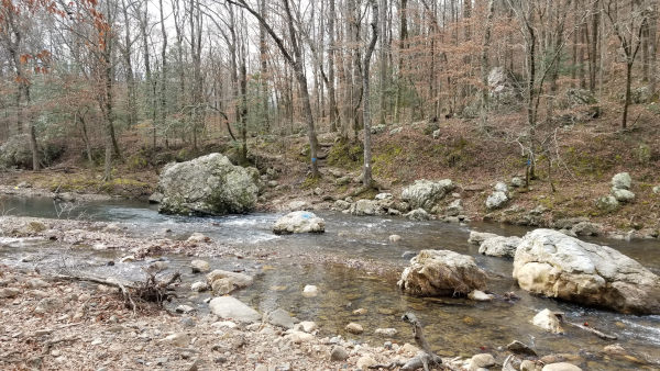
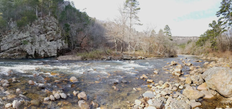
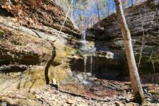
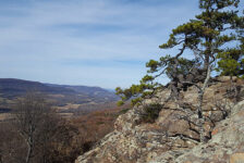
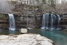
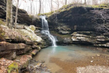
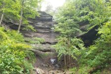
The hike to Winding Stairs has a little bit of everything. It has views of several mountains in the distance at nearly every point of the hike. There a couple of nice vista views along the trail and two different water crossings. Views of the Little Missouri River can be seen at many points along the trail, which is one of the scenic highlights of the hike. The crystal clear water is fairly calm in some parts, and in others it rages around large boulders and over rapids. And in the deeper pools, the water is a gorgeous emerald green. We also saw a couple of small waterfalls and caves. And once you get closer to the Winding Stairs area, the giant boulders and rock formations are really amazing. Your camera roll will be full after this hike!
It’s just my opinion, but I think this hike is probably best from late Fall to early Spring. Maybe I’m wrong, but I think the views of the mountains are probably best while the leaves are off the trees. I like seeing the exposed rock cliffs and ridges that likely get covered up by trees in the Spring and Summer. I can also imagine the ticks and insects being bad in the Summer. The trade-off is that the water is super cold in the Winter and must me waded. But I think it’s worth it for the better views.


All the Turns and Water Crossings
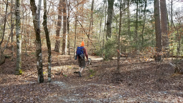
I recommend starting the hike off in your water shoes. The first water crossing (Blaylock Creek) is only a few hundred yards in. You might get lucky and find a downed tree in the creek to get you across without changing shoes. Below is the first water crossing.
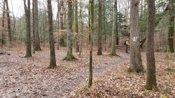
The confusion on this trail for most people comes right after the first creek crossing at Blaylock Creek. After that crossing, take the trail left along the creek and then follow the white blazes to the right. Do not follow the blue blazes! There are just a couple of spots in the trail where you have to pay attention where to turn. Below are pics of the first fork in the trail and one more spot that is a little unclear on where to turn. In both cases, stay to the right.
Just before the second water crossing (Little Missouri River), the trail will meet the riverbanks at a point where the river bends to the left. There will be a white blaze on a tree along with several pink ribbons on some saplings. These ribbons are not random – they are there to indicate that is the spot to cross the river. The trail does continue a little further past that, where you can see a small mountain drainage waterfall. But this spot is the place to cross. The trail will continue directly across the river, marked by another pink ribbon and white blaze.

From that point it’s only about a half-mile to the Winding Stairs area and some spectacular scenery. We didn’t bother changing back to hiking boots knowing we were almost there, and then coming back to cross the river again. All these turns and water crossings are covered in detail in the video below so be sure to check that out. The video does more justice to the area than photos anyway.
Plan Your Trip
This hike can be done as part of a multi-day hike on the Eagle Rock Loop, or as an out-and back day hike. Either way, I consider this to be a destination hike. It is a pretty remote area that is a good drive from just about every part of the state. So even as a day hike, this should take up most of your day. If you start early enough, you can probably fit in a visit to Little Missouri Falls just up the road. As I mentioned, there is no cell service here. So research the area, plan your activities, and download maps before going.
I recommend sturdy hiking boots or trail shoes at a minimum. Don’t forget to pack creek shoes, a towel, and extra socks. If it’s cold weather, you will want pants that you can roll up past the knee. Also, at least one hiking stick is really helpful for the water crossings. The slick rocks and rushing water can make balance a little difficult. Pack at least one bottle of water and trail snacks. I recommend packing a lunch. The river is very clean, so filtering river water is an option. If you reach the Winding Stairs area and wish you had packed a hammock, don’t blame me. I’m telling you now you’ll want to hang out there a while. For my day hike or overnight hiking gear lists, click here.
A vault bathroom (“pit” toilet”) is available next to the parking area. There is a nicer restroom at the Albert Pike Rec area, but it may or may not be locked. The small community of Langley lies to the southeast, and has one country store with some food and drinks if you need it. As I always say, be prepared to pack out any trash you might have on your hike to Winding Stairs and leave no trace. Take only pictures and leave only your footprints. Be safe out there and I hope you enjoy this hike as much as I did.


Loyd Pittman
I live in Amity, not very far from this location. Im 47 and I remember my dad taking me to winding stairs when I was about 7 or 8….would love to get back there! May plan a overnight trip this fall…..thank you for sparking a memory and reinterest.
Scott Hallmark
Hi Loyd. Thanks for the comment. It’s a beautiful area. I could definitely re-visit this one many times!
Suzanne
Is there a map to download for Winding Stairs? I don’t see it on Hiking Project
Scott Hallmark
Hi Suzanne. I’m sorry I just saw your comment. Unfortunately, I don’t have a map for Winding Stairs. I had the same problem trying to find one. And at the time I did this hike, I wasn’t using an app where I could record my tracks. But in my video, I did walk through the steps and show each turning point in the hike from the parking lot all the way to Winding Stairs. When you leave the parking area, you’ll immediately cross Blaylock Creek. You’ll then go down the creek a short bit and look for white blazes in the trees. Follow the white blazes all the way. In the video, I show the 2nd water crossing and where the trail picks up from there. After that it’s a short walk to Winding Stairs. Sorry I don’t have a map, but I hope this helps.