When it comes to hiking, I learned long ago to plan your hike, research it, and know what you’re getting into. I’ve learned this lesson several times. But every now and then I seem to forget it, and will go off exploring without a plan. Or I’ll plan a hike and change my mind on the way so I can see something else. Such was the case the first time I made the hike to Magnolia Falls between Deer and Fallsville. I had planned two other waterfall hikes near Ponca that day in early October. But after seeing that the area creeks would be low on water, I opted for Magnolia Falls.
I had Magnolia Falls on my list for a while and even read a little bit about it. But I was still completely unprepared that day. I had not downloaded a map or read enough about how to access the other waterfalls nearby. Because of this, I only got to see Magnolia Falls and the top of Woods Boys Falls. And there wasn’t much water in those falls either. I knew I would have to research this area more and come back during wet season. This turned out to be a blessing in disguise. Because little did I know, but this hike is so much better in Winter after all the leaves have fallen. In fact, it’s now one of my new favorites.
Directions
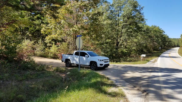
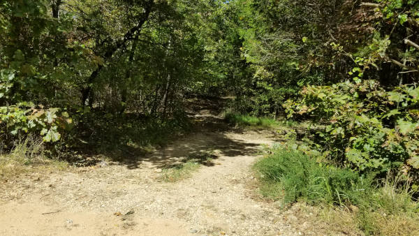
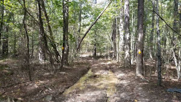
If arriving from the south, head up Hwy 21 north of Clarksville. After passing Fallsville, veer left at the fork with Hwy 16, continuing north on Hwy 21. Approx 1.8 miles from the fork, turn left at the blue 9050 road sign(shows as CR6 on Google maps). If coming from the north, head south down Hwy 21 from Kingston or Ponca. Turn right at the blue NC9050 road sign about 2.5 miles south of the Mossville cemetery. Once on NC9050/CR6, the trailhead will be on the right, just under a half-mile down the road. There are no trailhead signs. If there are no parked cars, look for a gap in the woods with dirt road leading into a giant mud hole. There are some trees here with yellow blazes. This is the start of the trail. See map and pics below.
What to Expect
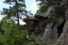
The trail is marked in yellow, but only in a couple of spots – at the trailhead, and at a point where the trail forks. But that’s OK. It’s a clean trail that’s easy to follow…most of the way. As the trail starts to go downhill, keep a lookout to the right to see the stacked stone wall. I could only see parts of it in October due to the vegetation. But in Winter you can see all of it, and it’s really cool. The wall runs about a quarter mile along the trail, just up the hill. It eventually begins to merge with some huge boulders and rock formations. The builders cleverly used those boulders as part of their wall. I recommend going up the hill to explore around the rocks and the wall for a bit.
Just a little way past the end of the wall is a small creek and a fork in the trail. This fork is marked with yellow blazes. At this point, you go left to get to Magnolia Falls. Going straight here will lead to the bottom of the bluffs, and eventually Hadlock Cascade and Woods Boys Falls. There is way to see Magnolia Falls AND get to the bottom of the bluffs without backtracking here. I didn’t find the way in October, but Rick Henry’s blog details how to do it (thanks Rick!). Be sure to watch my video below where I walk you through it on the Winter hike. There are four waterfalls in this hike.They are so close together that it doesn’t make sense to do the hike without seeing them all. Here’s how to get to all four.
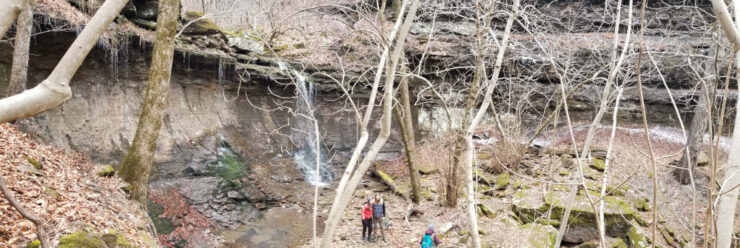
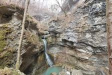
Magnolia Falls
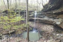
At the fork marked with yellow blazes, go left. The trail winds downhill maybe 150 yards or so to reach the bottom of Magnolia Falls. It opens up into a nice grotto where the falls are to the left. And to the right, the trail crosses another creek and continues on to the bluffs overlooking Woods Boys Falls. It also wraps around the left side of the grotto to the top of 26-ft-high Magnolia Falls. To this point, it is just about one mile and I would rate the trail as easy. When the falls are flowing well, this is a really nice waterfall and worth the short hike on it’s own.


Woods Boys Falls
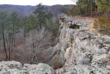
From the Magnolia Falls grotto, follow the creek bed about 50 yards and you’ll see the top of Woods Boys Falls. Getting to the bottom from here is the tricky part. You can backtrack to the first fork in the trail I mentioned earlier. Or you can take the trail along the top of the bluffs that is marked with pink ribbons. I recommend the second option. In the Winter you can see things across the ravine from this trail that aren’t visible in the Summer. On the left will be a break in the bluffs where you can climb down to the cliff base. A lot of people miss this part, so I point this out for you in my video below.
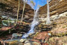
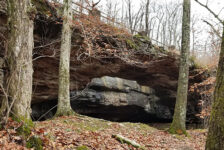
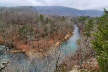
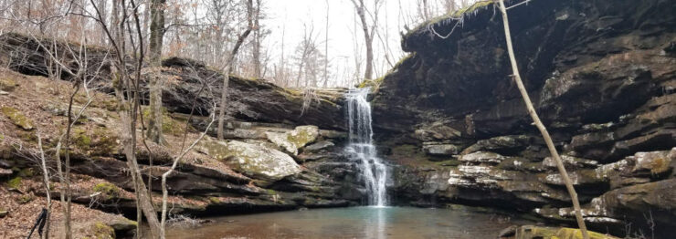
Once you reach the lower level, stay on the trail close to the bluffs. This will lead you all the way to the bottom of Woods Boys Falls. The trail is really clean here with not much vegetation. And the huge bluffs, rock formations, and small caves are pretty awesome to see. As you approach Woods Boys Falls, the trail is mostly large rocks so watch your step. The grotto that produces the 33-ft tall waterfall is pretty good size. It doesn’t seem as high from the bottom as it does from the top. But it’s a nice grotto and great waterfall. To this point, I would rate the hike as moderate due to the climb down the bluff. I estimate the distance of this section around 1-1.5 miles.


Stahle Falls
To reach Stahle Falls from Wood’s Boys, follow the tall bluffs on the opposite side of the ravine from where you came in. So cross the creek or walk behind the falls following the grotto wall to the other side. There is not a very clear path here, but as long as you follow along the cliff base, you’ll be fine. Those bluff wrap around into another small hollow, and there you’ll find Stahle Falls. It’s only about a quarter mile walk from Woods Boys. You’ll walk right up on it and can’t miss it.
At just a little over 60 feet high, Stahle Falls is the tallest in this group. As you might imagine, the grotto forming a waterfall this high is pretty large. As long as there’s water in the falls it’s a pretty impressive sight. This waterfall is actually on a different drainage than the other three falls on this hike. And it’s tucked away in a hollow that’s not visible from the main trail. So unless you’ve done your homework, it’s unlikely you’d ever know it’s here! I would rate this short section of the hike as easy.


Hadlock Cascade
The best way to reach Hadlock Cascade from Stahl Falls is to backtrack to Woods Boys. Again, it’s short walk. Cross the creek again to hit the same trail along the bluffs where you came in. About 100 yards downstream from Woods Boys, you’ll find some side trails venturing toward the creek. These will lead down a steep and rocky path to the bottom of Hadlock Cascade. I have also pointed this out in my video. The trail kind of ends and you have to find your way down the large rocks to the bottom. It is steep and covered with leaves, so watch your step.
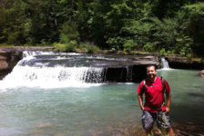
Hadlock Cascade is a 27 ft waterfall inside – you guessed it – another nice grotto. But this grotto opens up a little more around the creek and is a pretty nice place to hang out. If I were camping or hanging a hammock on this hike, this is the spot I would do it. From here, we made the steep climb out of there and back to the main trail. I would rate that part as difficult. To get back to the parking area, you can go back up the break in the bluffs and backtrack the whole trail. Or you can stay on the trail as it wraps around the end of the bluffs and back up the hill. It will take you back to the first fork in the trail that I mentioned close to the beginning. We went that way and it was a pretty good workout, which I’d rate as moderate.


I missed getting photos of the marked fork in the trail as well as the break in the bluffs leading to the bottom of Woods Boys Falls. So be sure to watch this video to catch those parts!
Plan Your Trip
I absolutely recommend doing this hike during the winter or AFTER all the leaves have fallen. There is so much to see in the Winter that is not visible when leaves are on the trees. Plus it’s a little overgrown in the summer, so poison ivy and ticks may be bad. Definitely go after some rain. There is no cell signal here, so be sure to do your research ahead of time. Download/screenshot all the maps and info you need before going. I don’t know the exact distance to cover all 4 waterfalls, but it’s less than 5 miles for sure. One member of our group tracked it at around 4.5 miles. But that includes all the steps from us exploring caves, playing around the falls, etc. We really took our time, explored a lot and took breaks. Even with all that, we finished in about 4 hours.
If you are really ambitious and get an early start, you can probably fit another hike in your day if you want. For that I would recommend Glory Hole Falls or Lost Valley since both are only minutes down the road. There are plenty of other trails in the area to hike and places to stay if you want to make a weekend of it. Up the road in Ponca are two general stores with food, drinks, supplies, and restrooms if needed. You’ll also find cabins there.
This trail is not on Buffalo River NPS property, so pets ARE allowed. I do recommend keeping them on a leash around the top of the bluffs though. There are no real water crossings on this hike. The creeks can be crossed without getting wet. I also recommend packing plenty of water and trail snacks, or even a lunch. But be prepare to pack out any trash you have and leave no trace. This area is not managed or maintained by anyone, so it’s up to us to take care of it. Please do. I hope this helps someone find their way around and see all this hike has to offer. Happy trails!