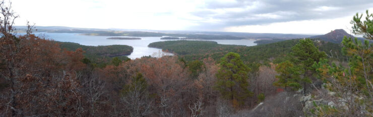
Living in Central Arkansas, I’ve watched the sun go down many times from the top of Pinnacle Mountain. From my spot on the north peak, I’ve looked to the west and wondered “what is that other mountain over there?” And “it sure would be cool if we could hike to the top of it and look back this way.” Well, that mountain “over there” overlooking Lake Maumelle is Rattlesnake Ridge. And in 2018 it was opened to the public for hiking by the Nature Conservancy and Arkansas Dept of Natural Heritage. Finally, a much-needed new place to hike close to home! I love Pinnacle, but after you’ve been to the top 150 times (not kidding), it kinda loses its luster. In 2019, mountain bike trails were added so we can now go hiking OR biking at Rattlesnake Ridge! It’s also a good place for local rock-climbing, if that’s your thing.
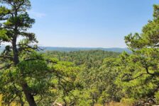
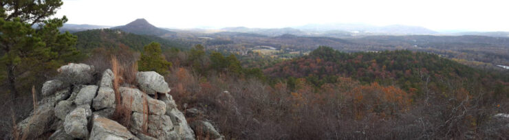
Almost as soon as Rattlesnake Ridge was opened, I was there hiking the trails. I couldn’t wait to see what Pinnacle Mountain and Lake Maumelle looked like from the top of the ridge. And I was not disappointed. The lake looks a lot different from that vantage point. And you can see things further west and in the valleys that aren’t as visible from Pinnacle Mountain. Speaking of Pinnacle, it’s really cool to see a new view of that big rock as you look back east towards town.
Directions
From Hwy 10 west of Little Rock, go north on Barrett Rd for 1.2 miles. After the road makes a sharp right turn, look for the signs on the left for the parking area. See map below.
What to Expect
This is a Natural/Conservation Area protected by the Nature Conservancy. This has several implications for hiking or biking at Rattlesnake Ridge. First off, it will not be crowded because access is limited. If the parking lot is full, you have to come back later. Next, they try to keep the area as natural as possible. So the trails are not marked as well as you might like. There are a few signs along the way, but no tree markings. And finally, to protect the trails the park may be closed during wet conditions. You might not like all of these things. But if it keeps the place from getting torn up like Pinnacle Mountain has, then I’m all for it.
Hiking
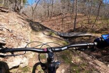
When I first started hiking here, the trails were mostly washed out ATV trails running pretty much straight to the top. And the maps were confusing because nothing out there was marked. Now that the MTB trails are open, they don’t want you using the old ATV trails anymore. If you want to hike to the top, you take the Cliffbrake Trail. The downside is that it’s a MTB trail that winds its way gradually up the hill, making it a longer walk to the top. But the good thing is that it’s a gradual incline and an easier walk. That is until you reach the bottom of the rocky ridge. From there, it is hikers-only and much steeper.
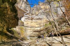
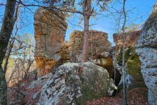
The top of the rocky ridge is where the best views are. The trail at the base of the ridge runs to both ends, east and west. I prefer the east end of the ridge. For one, it’s a better view of Pinnacle Mountain. But also, it’s a little easier to navigate the rocky climb. No matter which end of the ridge you choose, be prepared to climb a few rocks to get to the top. The west end of the ridge is also worth exploring if you have time, or make a return trip. It’s a little trickier to navigate, but worth doing.
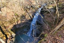
There are some other bluffs and views throughout the park that are worth hiking to. Close to the end of the Mountain Boomer trail is a lookout point on a bluff facing south. There is a nice view here of the mountains and nearby valleys to the south. This area is also accessible from the Timber Trail. I would rate the hiking out here as easy on the MTB trails. Once you get off those trails, they become moderate to difficult.


Biking
The first thing you need to know is that this place is not ideal for beginners. All of the bike trails are rated from Intermediate to Expert level. That’s not to say beginners can’t ride here. Quite a bit of the trails are fine for beginners to ride on. Just understand that it was designed for more advanced riders. So you are going to encounter areas that will require pushing your bike over or around obstacles, rocks, etc. There’s nothing wrong with that. But it does disrupt the flow of your ride and take some enjoyment out of it if you can’t handle the technical parts. If you’ve gotten spoiled by riding the Monument Trails at Pinnacle or Mt. Nebo, you’ll find these to be not quite as friendly.
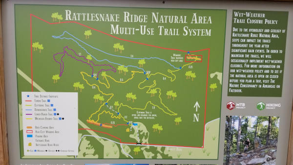


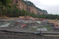
There are just over 5 miles of MTB trails here, designed and built by professional trail builders and volunteers. You’ll find jumps, rock features, berms, bridges, wooden paths and ramps, etc. Everything you need to work on your MTB skills is here. You’ll see a lot of these in my pics above and video below. Here is a list of all the trails at Rattlesnake Ridge.
Rattlesnake Ridge Trails
- Cliffbrake – Blue (Intermediate) – 1.6 mi. – uphill only for biking, up or downhill for hiking.
- Diamondback – Blue (Intermediate) – 1.4 mi.
- Mountain Boomer – Black (Difficult) – 1.5 mi.
- Lower Kanob – Black (Difficult) – 1.1 mi.
- Upper Cliffbrake – Black (Difficult) – 0.2 mi. – Hiking only
- Timber – Blue (Intermediate)- 0.25 mi. – To rock climbing area – Hiking only.
Read more about these trails from the MTB Project
Plan Your Trip
Whether you are hiking or biking at Rattlesnake Ridge, there are two really important things to remember. First, have a backup plan in case the parking lot is full. Like I mentioned earlier, there is limited access here. If the parking lot is full, you have to come back later. I recommend driving a few miles east and hiking or riding at Pinnacle Mountain for a bit and check back. The second thing is, it is a must to download the MTB Project app. Again, the trails are only marked with a few signs and their maps don’t show landmarks. Some places are a little confusing, so the maps and GPS in the app are really helpful.
Rattlesnake Ridge is pet friendly and cell service here is good if you need it. However, there are no restrooms. But those can be found at Pinnacle Mountain or a few miles away in West Little Rock. Plan on taking at least an hour or two for hiking the top of the ridge. Plan on another hour or so if you want to explore all the trails. As always, be prepared to pack out any trash you have and leave no trace. Have fun hiking or biking at Rattlesnake Ridge!