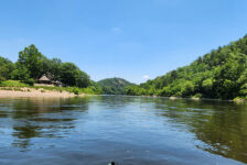
In the northeast corner of the Ouachita Mountain region lies the Flatside Wilderness area. It is an area that’s relatively less explored and often overlooked. I think this may be because exploring this area requires a LOT of dirt road driving, which may turn some folks away. Personally, I like driving those dirt roads. I think another reason is that people mostly hear about the beautiful scenery and waterfalls in the Ozarks, because it’s the most popular area. Hey, I get it – the Ozarks are still my favorite too. But there is also great scenery – including waterfalls – in the Ouachitas. One of those is Forked Mountain Falls in the Flatside Wilderness area.
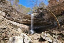
Forked Mountain can be seen from many different places while driving through the Flatside Wilderness area. Although it’s not the highest mountain in the area, it is easy to spot from a distance. Much like Pinnacle Mountain, it sits by itself away from other mountains, rising 1350 ft above the pine forest. Just to the east of the mountain’s base, you’ll find Cedar Creek and Forked Mountain Falls. This is probably the best waterfall in the Flatside area. If you are looking for a quiet place to explore, away from people, the Flatside Wilderness Area is a great option. It is a vast, mountainous pine forest that is eerily quiet and feels very remote when you’re out there. It is also pretty convenient for folks in Central Arkansas, Hot Springs, or the River Valley areas.
Directions
From Little Rock, take Hwy 10 to Thornburg. Or from Conway take Hwy 60 to Perryville. Turn south on Hwy 10 to the Community of Thornburg. At Thornburg, head west on County Rd 39 and turn left onto Trail 86. Follow that all the way to Forest Rd 793. (It’s a LONG way down a gravel road.) From all points west of Hwy 7, take Hwy 7 to Trail 86 near the South Fourche La Fave River. (It’s a shorter gravel drive from Hwy 7). Head east on Trail 86 and turn right on Forest Rd 793. Upon reaching the end of Forest Rd 793, you’ll cross a low concrete bridge and the road will dead end at the parking area. Use the map below to navigate to the parking area. A picture of the parking area is below as well.


What to Expect
Two Trails
To reach Forked Mountain Falls there are two different trails you can take. Both are easy hikes. One is an old road/ATV trail past the gate at the back of the parking area. Go around the gate and stay on that road. It will take you uphill, level off, and lead straight to the falls, around 1 mile. From this trail there is a great view of Forked Mountain. This is the trail I would take if I just wanted to get to the falls and didn’t care about the creek. It’s also the route I would take in the Spring or Summer because it’s wide and clear. I could see the other trail possibly getting overgrown. If you are not skilled at navigating in the woods without a clearly marked trail, then take this one.
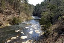
The other trail starts at the seven vertical posts you can see from the parking area. This trail follows along Cedar Creek all the way to the falls. It’s a pretty hike along Cedar Creek and worth exploring. Although the trail is not marked at all, it’s pretty clear for the first half. But close to halfway, the trail is hard to follow and it is not obvious where to go in several spots. I crossed the creek several times to stay on what looked like a trail. The water was low and I didn’t need creek shoes to cross. As long as you stay close to the creek, you’ll find your way to the falls. This route is also easy hiking as long as you can navigate it. I didn’t record it, but I estimate this route to be around 1-1.5 miles.


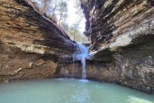
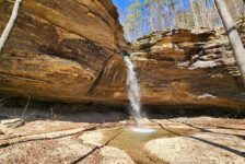
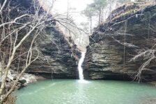
The Waterfall
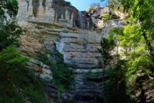
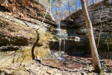
No matter which trail you take, both will lead you right into Forked Mountain Falls. Its about a 7 or 8 foot cascading waterfall then empties into a nice clean pool. It looks like a great little swimming hole. The trail wraps around the left side leading to the top of the falls. There you’ll find a huge rock shelf creating the falls, and the creek continuing upstream. You’ll also see a really cool rock formation towering over the creek on the left side. This would be a great place to spend an afternoon in the Spring.
In my video below, I stated that this is probably a one-time visit for me. Maybe I’ve been spending so much time hiking the Ozark waterfalls that I was a little underwhelmed with this one. But after reading more about it, I might have to go back. I didn’t realize it that day, but apparently there are more falls upstream from this one (Twist Cascade). I was limited on time that day so I didn’t explore further. I’ll hit this one up again to find the other falls and maybe climb Forked Mountain.
Plan Your Trip
No matter which direction you come from to reach Forked Mountain Falls, you’re going to have a pretty drive to get there. If you are coming from Little Rock/Conway, just know it’s a long drive down gravel roads. Parts of the road are pretty rough or muddy, but four wheel drive is not necessary. If you’re coming from that direction, you might consider a stop at Flatside Pinnacle on the way. For those coming in from Hwy 7, there are a few other hiking trails south of Trail 86 you can explore if you want to do more. If you feel really adventurous, you might try hiking to the top of Forked Mountain. But do your homework on that one. It’s not a well-marked trail and pretty much up to you to find your way to the top. But you’ll get a great view of Flatside Wilderness.
There is ZERO cell signal out there, so download or screenshot maps before you go. You can find that on the AllTrails app here. This is a pretty remote area so bring water and snacks if you want to make a day of it. Water shoes would be a good idea if you go after a heavy rain or want to swim in the pool. In the summer, I would recommend some bug spray. Be prepared to pack out anything you take in with you and leave no trace. As always, take only pictures and leave only your footprints. Enjoy the hike!