If you hunt enough waterfalls in Arkansas, you will eventually miss one that’s close to an area you’ve already hiked. I like to cover as much as I can in each hiking trip and article. So when I miss a cool feature on a hike, it’s pretty common for me to go back and do it again. One area that I’ve recently revisited for this exact reason is Horsetail Falls off Falling Water Creek. I did an article last year on Six Finger Falls and Fuzzy Butt Falls. On that hike, I accessed Fuzzy Butt Falls by crossing Falling Water Creek at Six Fingers. I knew the trail went back upstream to the bridge crossing Falling Water Creek. But what I didn’t know was that the trail takes you right by Horsetail Falls!
I had heard of Horsetail Falls before but had never looked it up. So I didn’t realize it was among the many other waterfalls along Falling Water Rd that I’ve visited. In fact, it’s so close to Fuzzy Butt Falls and Six Fingers that it only makes sense to combine all three in the same hike. Another reason to take the trail to Horsetail Falls is you cut out the water crossing to reach Fuzzy Butt Falls. I revisited Richland Creek a few weeks ago with some friends. On the way, I was able to stop and fit in this short hike to see what I had been missing.
Directions
To reach Horsetail Falls on Falling Water Creek, head north on Hwy 7 past Dover – or south from Harrison on Hwy 7 – to the Sand Gap/Pelsor area. At the intersection at the Pelsor Post Office, go east on Hwy 16 towards Ben Hur. Keep going on Hwy 16 past the parking area for Pedastal Rocks/Kings Bluff and proceed through the Ben Hur community. Approximately 1.15 miles past the sharp right turn in Ben Hur will be Forestry Rd 1205(Falling Water Rd) on the left. Turn left there and at approximately 1 mile, keep to the left as it merges with Falling Water Rd. Approximately 1.25 miles past the merge will be the parking area for Falling Water Falls on the right. Continue on Falling Water Rd until you reach the narrow concrete bridge. Park at either end of the bridge. See Google map below.
If you park before the bridge, the trail is on the left side of the road. If you cross the bridge to park, walk back across the bridge. The trail will be on the right side of the road about 50 yards off the creek.. It is a horse trail you’re looking for, so it’s pretty wide. You can’t miss it.
What to Expect
The Horse Trail
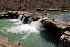
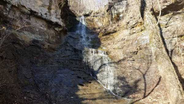
To access Horsetail Falls off Falling Water Creek, you will first take the horse trail that leads to Fuzzy Butt Falls. This is a wide, clean and very easy trail. It is not well-marked, but it’s so heavily trafficked it doesn’t really need to be marked. From the trailhead, it is 1 mile to Fuzzy Butt Falls. At about the 0.4-mile mark is the trail to Horsetail Falls. You’ll know you’re there when you walk up on a creek crossing the trail. That’s the drainage from Horsetail Falls. On the right you’ll see a really beautiful view of Falling Water Creek. And to the left is a nice little cascading waterfall. The trail to Horsetail Falls is on the left, just before that little waterfall and creek. I have featured this turn in the pics and video below, so be sure to check those out.


Two Waterfalls
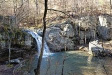
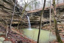
Surprise! There are actually two waterfalls here – Lower Horsetail and Upper Horsetail Falls. When you take the trail at the creek, it is all uphill. So at that point, this hike switches from very easy to slightly moderate. The trail can be a little hard to follow from late Fall to early Spring due to all the leaves. The first part of it stays pretty close to the creek. You’ll reach Lower Horsetail Falls first. It’s a really high grotto style waterfall that drops straight down. I came up the creek bed and arrived at the bottom of the falls. I recommend this route.
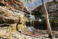
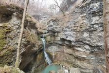
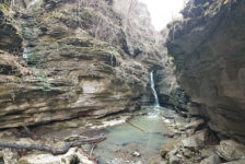
Leaving Lower Horsetail Falls, I found a good route to climb up out that little gorge to get a different view of the falls. This is also necessary to access the trail to get around the grotto and on up to the next one. At this point, the trail is a little hard to follow. I kind of went back and forth between the creek and what I thought was the trail. Once again, I came up the creek bed at the end to reach Upper Horsetail Falls from the bottom. Upper Horsetail is less of a grotto and more a bluff with cascading waterfall flowing down it. The two waterfalls are very different but equally impressive.
Again, I climbed out of that little gorge for a better view and to access the trail out of there. From the Horse Trail to the Upper falls is only about a quarter mile. It is all uphill, but at least it’s short. I definitely recommend combining these falls with Fuzzy Butt and Six Fingers. It’s a short easy hike to all three. And using this route, you don’t have to get wet trying to cross Falling Water Creek.
Plan Your Trip
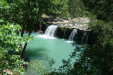
This area is one of the most highly concentrated areas for waterfalls in the state. If you come in from Sand Gap, you’ll pass by the trail head for Kings Bluff Falls. As you drive down Falling Water Rd, you’ll pass right by the popular Falling Water Falls. Just down the road from Six Fingers is the trail for Terry Keefe Falls along with Calypso and Splashdown Falls (link coming soon). And even further down Falling Water Road, and deep in the wilderness, you can find Richland Falls and Twin Falls. Unless you want to hang out here all day, you might consider planning a hike to one of the others to fill out your day. Remember, this is a pretty remote area as far as cell service goes. You will lose cell service long before you reach Falling Water Rd. So if you plan to hike other trails, download or print a map before you go.
It might be important for some people to know that Falling Water Rd is a long gravel road. It is rough in some places, but most vehicles should be able to handle it. There are also no public restrooms near here. The Pedestal Rocks parking area has a pit toilet, but that’s about it. So unless you’re cool with going in the woods, you’ll need to handle your business well before you arrive. There are also no gas stations or convenience stores within 45 minutes of here, so keep that in mind. If you plan to spend all day, you might want to take food with you, but definitely take water. Water shoes are handy for creek crossings unless you want to barefoot it, or if the water is really low.
Another thing to remember is that these short hikes are really popular with people that can’t or don’t want to do long hikes. They do get kind of crowded sometimes, especially when the weather is really nice. If photography is your thing and you want pics without people in them, it’s best to go when it’s cold or rainy. Middle of the week is probably better too. The water level in Falling Water creek does tend to get much lower in the hot summer without any rain. You’ll want to plan for that too. Regardless of when you go, remember to leave no trace. This sort of thing has become extremely popular and these areas are getting more and more traffic. Please remember to take only pictures, and leave only footprints. Thanks.