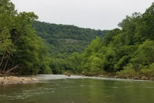
Here we are in June and it’s still raining like it’s April. Floating the rivers is a little unpredictable right now. But one thing you can rely on is that the waterfall hiking is excellent pretty much every weekend. Earlier this spring I ventured into the hills northwest of Batson to visit Bingham Hollow Falls. Along the way, I stoppled to make the short hike to Mineral Springs Falls.
I was actually on my way to a weekend camping and floating trip on the Mulberry River. That float ended up cancelled due to some unexpected cold and windy weather. So the waterfall hike to Mineral Springs Falls and later to Bingham Hollow wound up as the highlight of the weekend. Bingham Hollow was as great as I thought it would be. But Mineral Springs Falls was much more than I expected, and a nice surprise.
Quick Glance
Distance: Approximately 1 mile round trip out-and-back
Difficulty: Moderate
Mineral Springs Falls Coordinates: 35.642780, -93.728060
Mineral Pool Falls Coordinates: 35.641880, -93.727950
Directions
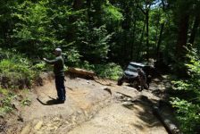
From I-40 at Ozark, go north on AR -219 for 8.5 miles until the road forks. At the fork, go left on Pink Twist Rd, aka Co Rd 88/Forest Svc Rd 1504 for 4.1 miles. You’ll see a pulloff on the right that leads to a closed gate. That’s the parking area. If you come in from north of the Mulberry River on Hwy 23, head east on AR-215/Cass Oark Rd. Just past Redding Campground, look for a gravel road on the right leading to a concrete bridge across the Mulberry River. This is Forest Svc Rd 1504. And if you’ve ever floated the Mulberry, this bridge is the one you float underneath just a bit past Byrd’s. Cross the bridge and stay on Forest Svc Rd 1504 for 4.9 miles. The parking area will be on the left. Use the Google map below to navigate to the parking area. The video further below shows you a visual of the parking area
What to Expect
The Hike
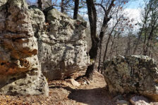
The hike to Mineral Springs Falls is a short one. It is an out-and-back hike that is just under a mile round-trip. There is not much of a trail, and in some spots it’s a little bit of a bushwhack. When you pass by the gate, follow the path across the open field. Along the treeline across the field, look for orange or pink ribbon in the trees. That is the point you want to head down the hill toward the falls. In some spots the path (not even a trail) will completely disappear. In those spots, look for flattened grass and leaves, or some sort of tracks. Most importantly, keep looking for the orange or pink ribbons in the trees. They ARE out there, marking the way.
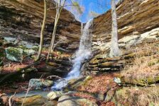
As you get closer to the falls, the hill gets pretty steep. There are some loose rocks and a lot of leaves, so be careful walking down the hill. Keep following the ribbons in the trees. It will eventually turn into a cleaner trail as it approaches the descent into the grotto. Once you catch a glimpse of the grotto, you’re pretty much there. This is Mineral Springs Falls. Mineral Pool falls is downstream from there. I rate the hike as moderate due to the light bushwhacking, and the steep climb out of there. The hike may be short, but it’s not exactly easy.


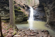
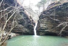
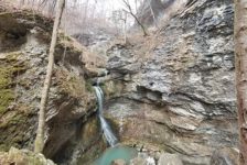
The Falls
Mineral Springs Falls flows through a nice sized grotto that seems out of place after crossing that field. I must be a good judge of distance because I said the falls look about 40 ft high. That was before I saw the waterfall info in Tim Ernst’s book, where he lists it as 43 ft high. It’s a pretty awesome looking grotto with rocks that are layered in a really cool way. I haven’t seen a whole lot quite like that. You can walk down to the bottom of the grotto, behind the falls, all the way to the other side. I recommend it too because pictures from the other side are the best.
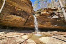
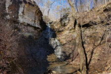
It appears the best way to Mineral Pool falls is to go straight downstream from here. At least that’s the best I could tell from Tim’s book and Rick Henry’s blog – and by getting a look at it. But the area was pretty grown up with vegetation on our visit. And it didn’t seem like it was worth it based on pics I’ve seen. Plus we wanted to make it up to Bingham Hollow that day and still have time to set up camp at the Mulberry. So we skipped Mineral Pool Falls. Sorry! But I’ve listed the coordinates for it above. Have at it!
Plan Your Trip
It is about a 5 mile drive on a gravel road to the parking area, no matter which direction you come from. But it is a nice gravel road, so 4-wheel drive is not necessary. Although this is a nice waterfall, I would not make this drive just to do the hike to Mineral Springs Falls. But there are plenty of other waterfalls nearby that you can add to your day, making this a very worthwhile stop. As I mentioned, Bingham Hollow and Sentinel Rock Falls are minutes to the north. The White Oak Creek group of waterfalls are minutes to the west of here. And there are several waterfalls just north of Batson, as well as the Horsehead creeks and hollows south of Batson. There are campgrounds at nearby Horsehead Lake and several campgrounds and cabins around the Mulberry River. So it would be easy to make a weekend of hiking this area.
I’ll go back to this area in the winter to explore as many of these waterfalls as I can. I think this whole area is probably going to be better hiking in the winter. That’s because it gets less foot traffic than the more popular trails around the Buffalo River area. Some of them get kind of overgrown and require a little bushwhacking. This one had a few briars across the path and a good bit of undergrowth and leaves. So I recommend long pants and bug spray for this hike. I also recommend loading the waypoint coordinates I’ve listed above into a GPS. It helps a lot in areas where there is not a clear trail. I use the Gaia GPS app on my phone and it works great. Cell signal is spotty to non-existent, so be sure to load those and any maps before you go.
Because of the steep hillside, hiking boots and trekking poles are helpful for this hike. Be prepared to pack out any trash you may have and leave no trace. As always, take only pictures, and leave only footprints. Have fun and enjoy the hike.