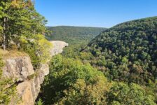
A couple of weeks ago I wrote about a recent visit to Mountain View, AR and all the fun things to do around there. Our first stop that day was at Loco Ropes for some ziplining and ropes adventures. You can check out our visit to Loco Ropes here. The second half of our day would take us into the Sylamore Wilderness for a hike to Steele Falls. It’s actually the Sylamore District of the Ozark-St. Francis National Forest. But right or wrong, I just call it the Sylamore Wilderness. Before we would get to Steele Falls though, we had a few other stops to make.
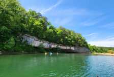
First was lunch at Wing Shack in Mountain View (great burgers!). Then we made a quick stop at Blanchard Springs to check out Mirror Lake Falls. From there, we made our way to the area of Fifty-Six and a stop at the beautiful Gunner Pool Campground. You have to pass through the Gunner Pool Area to get to Steele Falls so you might as well stop and look around. But with a hike to Steele Falls on our agenda, we couldn’t stay long. We crossed the big iron bridge and made the long gravel drive to our final hiking destination.
Quick Glance
Distance: Approximately 2.5 miles out and back
Difficulty: Moderate
Parking Coordinates: 36.013343, -92.191850
Steele Falls Coordinates: 36.017930, -92.179572
Directions
Coming from the South or West, take Hwy 14 to the community of Firfty-Six. Head north on County Rd 93/Gunner Pool Rd, following the signs to Gunner Pool Recreation Area. After crossing the bridge at Gunner Pool, continue for 2.9 miles and turn right on County Rd 71/Green Mountain Rd. The parking area and trail head will be 1.1 miles down this road on the left. Coming from the North or East, there are several ways to get there off Hwy 5. The only one I have taken and know for sure is good is County Rd 71/Green Mountain Rd, about 8 miles north of Mountain View. Follow this road for 8.7 miles until you see the parking area on the right. Use the Google map below to find the best route for you.


What to Expect
The Hike
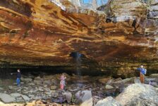
The hike to Steele Falls is about 2.5 miles round trip on an out-and-back trail. Once you’ve parked, go past the green metal gate and follow the ATV trail. This ATV trail can be seen on Google Maps, appearing as Branscum Rd. But it definitely is NOT a road you can drive. It’s an overgrown ATV trail, but it does take you almost all the way to the falls. At the point where the trail makes its first hard left turn, you may hear some rushing water. This is not Steele Falls. That is Mud Springs Falls. It is just down the hill from trail. It’s not far, but it is a steep and overgrown bushwhack. If you want to see that waterfall, I recommend going in the Winter when the brush has died. Watch my video below to see what I mean.
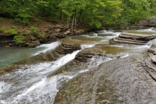
From there, the trail winds down into a hollow to a point where you will hear rushing water and eventually see a creek. There is a trail sign on the right with a clear-cut trail running along that creek. That trail leads to Steele Falls less than 100 yards away. All of this can be seen in my video below. I would rate this hike as moderate. The trail itself is easy, nothing technical about it. But the first half is all downhill, making the hike back all UPHILL. It will get the blood pumping and the sweat pouring. So for that reason, I rate it as moderate. I agree with AllTrails on the this one.
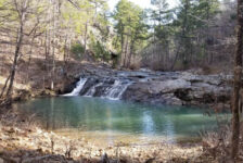
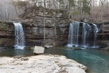
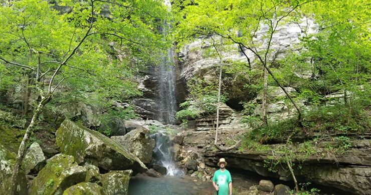
Steele Falls
When there is enough water, this is a pretty impressive waterfall. It’s totally worth the moderate hike. The waterfall is 66 feet high and drops straight down into a pretty secluded grotto. The walls of the grotto and the hillside make a pretty tight corridor that feels shut off from the rest of the forest. Because it is kind of tight and full of trees, it’s kind of hard to get a good picture of it. But it’s a very cool place to hang out. The splashdown of the falls on the rocks creates a misty breeze that feels great on a hot day. (TIP: if you have time to stay, take a hammock!).
Plan Your Trip
Our Hike to Steele Falls was within 3-4 days of getting some rain, so the falls were flowing pretty good. But I don’t think that is the case without some rain. So try to make this hike within a few days after a decent shower. Give yourself a couple of hours to do the hike and hang out to enjoy the falls. You might take a little longer if you want to work Mud Springs into the hike. If you do this one in warm weather, take some water because the hike out can be physically challenging. And definitely take some bug spray. It’s a good trail, but might get overgrown in places. Also plan on 20+ minutes of dirt road driving each way. These are pretty good gravel roads. 4-wheel drive is not needed. And don’t plan on having cell service.
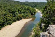
This hike won’t fill a full day. But there’s a lot to do around the Mountain View area if you want to make a day or even a weekend of it. Visit Blanchard Springs or Ozark Folk Center State Park. Or go mountain biking on the EPIC Syllamo MTB Trails. Unwind with some fishing on the White River or floating on Sylamore Creek. The music, shops, and restaurants in town are fun too. There are lots of options to stay at – hotels, cabins, condos, as well as campgrounds and RV parks. Whatever you choose to do, please recreate responsibly and leave no trace. Have fun out there!