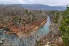
A recent camping trip this Fall unexpectedly led us to a new group of waterfalls I had not visited before. I say unexpectedly because our original camping destination (Cove Lake) was full when we arrived. I had Cove Lake area hikes planned out and everything! Altering our plans on the fly, we opted to spend the weekend at Longpool Campground near Dover. I’ve stayed at this campground and hiked to Longpool Falls many times. But until this trip, I had never made the hike to Rough Falls just down the road at Rough Hollow.
If you have ever been to Longpool Campground, you know there is no cell service there. Luckily, I had already spent a little time researching Rough Hollow on the Waterfalls in Arkansas map. There are quite a few waterfalls in this hollow that you can see in one hike. I had saved most of these way points and a couple of tracks in my GPS. On this day we only hiked to Rough Falls. I’ll explain why further below.
Quick Glance
Distance: Approximately 1 mile out and back
Difficulty: Moderate
Parking Coordinates: 35.53226, -93.14935
Rough Falls: 35.53339, -93.14486
Rough Falls Access off main trail: 35.532993, -93.145064
(Copy/Paste Coordinates into GPS or Google Maps search bar)
Directions
From Hwy 7 north of Dover, take Hwy 164 west towards Hagerville for 3.5 miles. Turn right on Old Hwy 7. At 2.8 miles, it turns into FR-1804 (Old Hwy 7 turns off to the right and continues on as a gravel road). 0.8 miles past this point will be the parking area on the right side of the road. Pull in there. Follow the logging road past the gate and keep going. This is the main trail to Rough Falls.
What to Expect
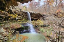
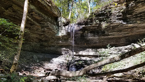
Rough Falls
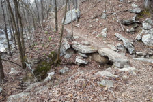
You could spend most of the day hiking to all the falls in Rough Hollow. But the hike to Rough Falls is a short one. Just past the gate, it is just under a half-mile each way down an overgrown ATV trail/logging road. It is not a well-marked trail, so I highly recommend using a GPS for this one. There are some tree ribbons marking the way, but they’re not all easy to see from the trace road. At this coordinate point (35.532993, -93.145064), turn right off the main trail. I feature this turning point in my video below. It’s only about 30 yards to reach the top of the bluff line. From there you can see part of the grotto and hear the falls.
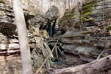
Walk along the top of the bluffline and look for ribbons in the trees and evidence of a small water drainage down into the ravine. This is where we made our way down to the creek to access the bottom of Rough Falls. It’s kind of a steep hill to get down, but not that treacherous, and not much undergrowth. Again, you can see all this in the video. It’s a pretty good size grotto surrounding Rough Falls. And it’s easy to walk from one side to the other behind the falls. There was not much flow in Rough Falls that day. Most of this hike I would rate as easy. But overall, I rate it as moderate due to the climb out of that ravine.


Other Rough Hollow Waterfalls
The main trail to Rough Falls is pretty overgrown (at least in October). There were a few briars here and there but not too bad. About halfway to Rough Falls, I saw ribbons that I suspect were marking the way to Slot Canyon Falls. But I did not see any trails. It looked like a pretty serious bushwhack through some thick vegetation to get there. Since there wasn’t much water in the creeks, we decided it wasn’t worth the bushwhack to reach the other falls. So we skipped Slot Canyon . We also skipped Ten Tier Falls, which is above Rough Falls on the same creek.
There are several other falls in Rough Hollow. We skipped those for the same reason. I’ve listed the coordinates for all of them below. I can’t comment on how difficult those are to reach or what the trails are like (if any). But if you do these, you definitely want these points saved in a GPS. I plan to go back during Winter when there’s more water and bushwhacking is a little easier.
Rough Hollow Waterfall Coordinates
Slot Canyon Falls: 35.53131, -93.14451
Ten Tier Falls: 35.53678, -93.14558
Rat Snake Falls: 35.532699, -93.141499
Trigg Falls: 35.534420, -93.140685
Big Rock Falls: 35.531838, -93.137997
Balcony Falls: 35.537500, -93.121899
Parking for Balcony Falls: 35.541806, -93.119639
(Copy/Paste Coordinates into GPS or Google Maps search bar)
Plan Your Trip
The hike to Rough Falls can be done in less than an hour. To do all the falls in Rough Hollow, I suspect it would take at least half the day, if not all day. It’s best to do this one in the winter or early spring when there’s fewer leaves and less undergrowth. This will make the falls more visible from the top. It’s also best to go during the wet season or after a good rain. I recommend long pants for this hike, even in warm weather, due to a few briars and weeds. Bug spray is a good idea too, and a hiking stick comes in handy for this hike.
There is no cell service in this area, so be sure to download all maps or GPS coordinates before you arrive. Pack out any trash you might have and remember to leave no trace. Stay away from ledges and be safe out there. I hope to follow up on this article soon with rest of Rough Hollow waterfalls, so stay tuned.