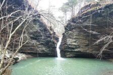
I find something to enjoy about every hike that I do. But some hikes are better than others. And then there are the ones that really stand out from the rest. Those are usually the ones where I spend the whole time thinking “how am I just now visiting this place?!”. The hike to Buzzards Roost is the latest one that really blew me away. Maybe it’s because I geek out a little bit over crazy rock formations (see video below), and this hike is full of them. This geological wonderland has two natural bridges and a huge rock outcropping/vista full of caves and tunnels. I would compare it to the Bear Cave Trail area at Petit Jean State Park, but more impressive.
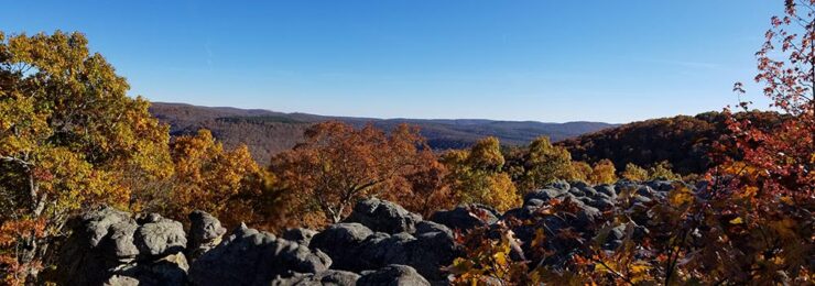
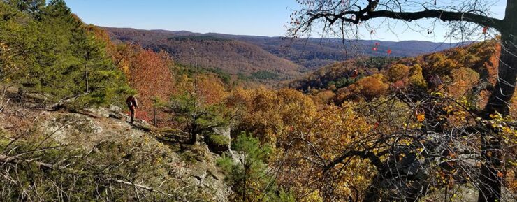
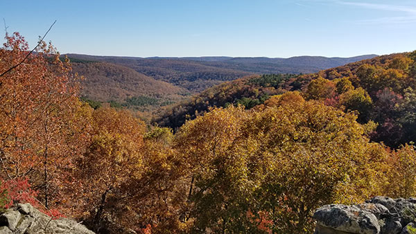
It also didn’t hurt that we caught this area on the last weekend of peak leaf season this fall. This hike has a couple of really great views of the Indian Creek valley southwest of Sand Gap. I’ve had this one on my list for years, saving it for a dry spell when there’s no waterfalls to see. Well, this Fall has been one of the longest dry spells I can remember. So after a quick visit to see the colors at Sam’s Throne , my buddy David and I set out for Buzzards Roost.
Quick Glance
Distance: Approximately 3.9 miles, out and back
Difficulty: Easy-to-Moderate
Parking Coordinates: 35.636690, -93.157854
Buzzards Roost Coordinates: 35.633868, -93.133440
Small Natural Bridge Coordinates: 35.634232, -93.133493
Large Natural Bridge Coordinates: 35.635380, -93.133173
My GPX Track file:https://www.gaiagps.com/public/mbp2IlUExXvdDQN79uw064gt
Directions
There are several ways to get to the Buzzards Roost trailhead. I’ve only been one way, so I’ll start with that one. We came in from the north down Hwy 7. From Hwy 7 at Sand Gap, head west on Hwy 123 for 4.7 miles and look for CR 1802 on the left. (We probably could have taken CR 1808, but I wanted to see some points on 1802.) Drive 3 miles to a fork and go left on CR 5991, which turns into CR 1805, aka Maupin Flat Rd. Continue for 3.5 miles. There will be a clearing on the left side of the road, just across from an old white house. That’s the parking spot. Once you leave Hwy 123, it’s all gravel roads. But the way I described is all smooth gravel roads that pretty much any car can handle.
If I were coming from the South (I-40, I would take Hwy 7 north past Dover. Just before Mack’s Pines, I would turn left on Old Hwy 7 and take that to CR 1805/ Maupin Flat Rd. This road goes north past Dover Lights overlook, crosses Indian Creek, and leads into the community of Treat. From there, 1805 winds it’s way north up to the Buzzards Roost trailhead. I can’t make a recommendation on this route because I don’t know the road condition. But next time I visit the area, I’ll be trying this route. Use the parking coordinates above or the Google map below to map your best route. < /p>
What to Expect
The Hike
The hike to Buzzards Roost is around 3.9 miles round trip, out and back. It is mostly a very clean ATV trail that goes all the way to Buzzards Roost. It is clean due to the ATV use, but it does have some large mud holes to go around. The trail does have a couple of forks and they are not marked with any signs or ribbons. So it is important to have a map or GPS to know where you are going. Or at least screenshot this article. For example, a left turn at the first fork in the trail will take you a long way in the wrong direction. Even with my GPS I got a little confused and almost took that left turn. Be sure to check out the video below where we figure that part out.
After a right turn at the first fork you’ll eventually come to another fork in the trail. Going left at the second fork will take you to the large natural bridge. Going right at the second fork leads to the Buzzards Roost and small natural bridge. I recommend going left first, and I’ll explain why below. According to some sources, you can hike straight from the large bridge down to Buzzards Roost, but it is a bushwhack. We didn’t see any trails there, so we backtracked to the last trail split. It’s not a far backtrack to return to the trail split and definitely easier than that bushwhack.
Overall I would rate this hike as Easy to Moderate. What I mean is that the main ATV trail is pretty easy. But some of the side trails around the large bridge and around Buzzards Roost are a little more difficult. There are a few uphill sections on the way back, but nothing too hard.
Large Natural Bridge
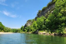
I’m the type that likes to save the best for last. For that reason, I recommend going to the Large Natural Bridge first. We accidentally went there first, but I’m glad we did. That’s only because the Buzzards Roost is the best part. The Large Natural Bridge is really cool too and should not be skipped. I don’t know the exact height of this bridge, but it felt like a good 50 ft high. It is comparable to the natural bridge at Alum Cove. There is also a cool pedestal rock here and and awesome view of the Indian Creek valley. If you have kids or pets, keep a close eye on them and don’t let them close to any of the edges here.
To reach the large natural bridge, you’ll have to break off the ATV trail to the right. Keep your eyes open for a slight trail going down the hill. I feature this in the video below. Walking over the bridge can be a little tricky. You have to climb up onto the top part of the bridge very close to the ledge, with 50-ft drops on both sides. If you’re not comfortable with that, there is a trail running along the cliff to the left across from the bridge that takes you to the other side. I also feature this in the video. We didn’t find a way to the bottom of the bridge, but we also didn’t look that hard. I definitely want to come back and explore this area more.


Buzzards Roost and Small Natural Bridge
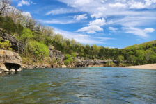
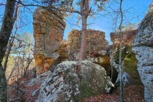
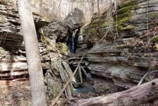
From the second fork in the ATV trail, turn right and it’s a very short walk down the hill to Buzzards Roost. And for me, this was when the rock-geeking really escalated. When you get there, you’ll be at the top of the giant rock outcropping. (It’s actually a huge cluster of giant boulders and monoliths.) It’s easy to walk out on top of the rocks from here, but be very careful hopping from one to the other. The crevices in between them are very deep and some of the gaps are really wide. A fall from these will be bad news. This is another area of the hike that kids and pets need to be supervised. But man is it cool! You can look down between the boulders to see the maze of trails below. And the vista atop these rocks gives you the second great view of the Indian Creek valley.
Walking around the sides of the rock outcropping in either direction will take you to the bottom of it. There you’ll find all kinds of caves, crevices and tunnels. We probably spent an hour exploring these. Looking up at these boulders from the bottom I was amazed at how HUGE they are. As we walked through the middle of the cluster, we met some folks that were camping out inside it. So of course we’re already discussing a campout there. If you walk all the way around the perimeter of this area, you’ll eventually run into the small natural bridge. It is on the north side of Buzzards Roost, or the left side as you are approaching it from the trail. It’s not nearly as impressive as the large bridge, but still pretty cool.
Plan Your Trip
Give yourself a minimum of 2.5 hours to hike to Buzzards Roost and the large natural bridge. Ideally, you really need 3-4 hours to thoroughly explore and enjoy this area. I could have easily spent a half day there. Like I said, I’m considering a campout here so I can explore it more. I’m not telling you that camping is allowed here. Buuuut….I did see people camping and will take my chances, assuming it’s OK. We also saw dogs on the trail, so feel free to take your pup. I think this hike is probably good to do year-round. But I have a feeling the best time is probably in the Fall and Winter for the views.
There are no restrooms here, or anywhere nearby. In fact, there’s nothing nearby except nature. So pack any food or drinks you want to take with you. Just remember to pack out any trash might have and leave no trace. You might want to pack a hammock too. It’s a good spot for it. Surprisingly, I had a strong cell signal for most of the hike. This is strange because it’s pretty remote and all the areas around it have little to no signal. Not that you’ll want it here – there’s so much to see. That pretty much wraps it up for Buzzards Roost. Add this one to your list for dry season hikes. You’ll be asking yourself “how am I just now visiting this place?!”.