*In Memory of Rick Henry.*
Rick, you may not have known most of your readers, but we feel like we knew you.
Thank you for leading us to so many beautiful places.
When it comes to waterfall hiking, it’s always great to get your money’s worth with multiple falls on a single hike. Most of the waterfall hikes in the Ozarks offer this opportunity, although some make it easier than others. My recent Christmas hike to Compton’s Double Falls and Amber Falls is a great example. Much like the Magnolia Falls hike, this one has several falls, each one just around the bend from the next. As long as there is water, you get to see five waterfalls on this hike. And you can continue down Whitaker Creek to see several more (Wild Burro, Beagle Point, and other smaller falls).
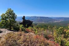
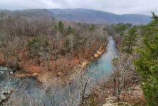
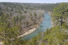
This is another one of those hikes that’s been on my to-do list for a while. After visiting Whitaker Point years ago, I became interested in exploring this area more. This trail is just a mile or two down the road from Whitaker Point. In fact, the creek that forms all these waterfalls is Whitaker Creek. This creek cuts through the deep valleys you see from the crag at Whitaker Point. It makes its way from the west, winding past Whitaker Point as it flows to the headwaters of the Buffalo River. All along Whitaker Creek are many feeder creeks and hollows full of waterfalls.
Quick Glance
Distance: Approximately 3 miles out and back
Difficulty: Moderate to Difficult
Parking Coordinates: 35.88759, -93.46965
Amber Falls : 35.88395, -93.47017
Unnamed Falls 1: 35.88386, -93.46781
Unnamed Falls 2: 35.88360, -93.46582
Compton’s Double Falls: 35.87930, -93.46257
Owl Falls: 35.87734, -93.46185
(Copy/Paste Coordinates into GPS or Google Maps search bar)
Rick Henry gpx track: Click here
Waterfalls in Arkansas gpx track: Click here
Directions
Compton’s Double Falls and Amber Falls are located in the Upper Buffalo Wilderness area. The trailhead is about an hour north of Clarksville, and about 20-30 minutes south of Ponca. It is just a mile or so west of Whitaker point, on the same road. If you are coming from Ponca/Boxley Valley, take CR 5 off Hwy 21. It is a rough dirt road with a winding, steep uphill drive past the Whitaker Point trailhead. If you are coming from anywhere other than Boxley Valley, I recommend coming in from the west by accessing CR 5 from Hwy 16, northwest of Fallsville. It is a slightly better road, not quite as rough and definitely not as steep. See Google map below. There is not a designated parking area. But there is a good wide spot in the road with a shoulder a few hundred feet from the trailhead. Park there.
What to Expect
The Hike
The hike to Compton’s Double Falls and Amber Falls is listed at 2 miles round trip on AllTrails, and by Tim Ernst. I don’t think that is correct, at least not for the hike I did. The route I took closely resembles Rick Henry’s and the Waterfalls in Arkansas gpx tracks. Those are 3.8 and 3.6 miles respectively. But they went a little further down Whitaker Creek than I did. Based on that, I estimate my hike to be around 3 miles.
If you read Rick Henry’s article on this hike, he states that there are no trails. That may have been true when he wrote it in 2015. But now, there is a decent trail for the most part. Some sections of the trail are clean and easy to follow. Other sections of the trail pass through rock beds, are covered with leaves, or cross over creeks. These sections are not quite as obvious, but are usually marked with an occasional tree ribbon. So look out for those. Also check out my video below where I walk you through these spots.
How I rate the difficulty of this hike depends on how much of it you do. From the trailhead to the top of Compton’s Double Falls, I would rate as moderate. That section is all downhill and physically easy. But it’s all uphill going back and is quite a heart pumper. It’s on the hard end of moderate. The other part of the hike is from the top of Compton’s Double Falls down to the bottom. This involves taking a barely visible trail along the top of the bluffs downstream to a bluffline break. The climb down the bluffline is a little sketchy. Traversing the rocky terrain to Owl Falls and back up the creek to the bottom of Compton’s is not easy. It’s still moderate for me, but will be difficult for some. Unless you’re a skilled/experienced hiker, I’m not sure this section is suitable to do without a partner.
Amber Falls
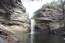
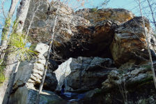
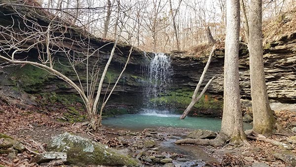
Amber Falls is the first waterfall you’ll see on this hike and that happens pretty quickly. Coming down the hill from the trailhead, it’s less than 20 minutes to reach this waterfall. Take a right at the first fork in the trail. This will take you to the bottom of Amber Falls. Along the way are some decent views of the Whitaker Creek Canyon. At the end of the canyon, you’ll find a nice grotto and the 18-ft high Amber falls. It’s a pretty waterfall and worth visiting on it’s own if you’re not up for the full hike to Compton’s.
Unnamed Falls
From Amber Falls you may be tempted to hike down Whitaker Creek. But don’t do that if you want to see these two unnamed falls. Go back up the trail and stay on the trail that’s high above Whitaker Creek. It will wind through two other hollows with drainages that flow to Whitaker Creek. They are not big waterfalls, but worth seeing if there is any water in them. These are easy to get to, and it’s probably a faster route anyway. I would take this route even if they were bone dry.


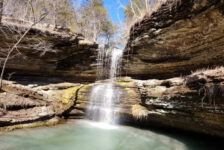
Compton’s Double Falls
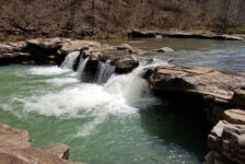
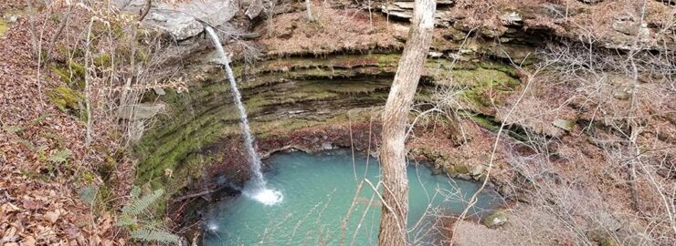
After the second unnamed fall, the trail will make it’s way down the hill to Whitaker Creek. From there, it follows the creek all the way to the top of Compton’s Double Falls. This is a 40-ft high waterfall that drops straight down. It’s called “Double Falls” because it flows into the pool below in two separate streams. When the creek reaches the top of the falls, it flows over thick slabs of stone where it has carved two separate slots. Flowing through those slots, the water shoots out into the pool at the bottom. It’s a cool site to see and makes for one of the more unique waterfalls in the state. It’s a nice view from here of the massive canyon below.
To reach the bottom, go along the top of the bluff on either side. I chose to cross the creek and go down the right-hand side. Going this way about 200 yards, there is a bluffline break you can take to get down to creek level. Then you come back up the creek to the bottom of the falls. I absolutely recommend going to the bottom for a view of this huge grotto and waterfall, if you’re comfortable with it. It’s a little tricky getting down and back up, so go slow and be careful. I show you all these steps in the video below.


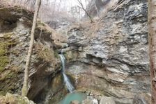
Owl Falls
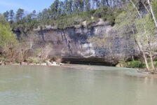
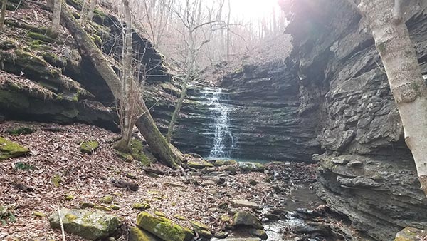
Just around the bend from the bluffline break is Owl Falls. This is another reason to go down the right-hand side of the canyon. In the video, I’m standing directly over a large boulder when I’m showing the bluffline break. Go to the right side of that boulder to get down. At the bottom of that, turn right and you immediately see Owl Falls. It’s a really cool cascade that flows down over layers of rock that stairstep down to the bottom. It’s one more good reason to descend into this ravine.
Plan Your Trip
The hike to Compton’s Double Falls and Amber Falls takes about 2 to 2.5 hours if you stop at the top of Compton’s. If you want to go to the bottom, allow yourself an extra hour. Had I not started so late, I would have continued on to Wild Burro and Beagle Point Falls. If you want to do those, get there early and add another hour or so to this hike. If you’ve never been to Whitaker Point, you could easily add that hike to your day if you start early enough. As for the drive, it is at least 6 miles of gravel road no matter which direction you come from. The road from Ponca/Boxley Valley is steep and very rough. I would not do that drive in a small car.
I crossed a couple small creeks on this hike, but didn’t need any creek shoes. Going further down Whitaker Creek might require them though if the water is high. There is little, if any cell service in this area. So download any maps, tracks, or waypoints you need before you go. There are no restrooms, and it is not close to any place with food or drinks. So you’ll need to handle all that well in advance. As always, be prepared to pack out any trash you have and leave no trace. Be safe out there and enjoy the hike.
* Rick Henry was the author of one of the most well-known and comprehensive hiking blogs in Arkansas. His detailed instructions, maps, and images have helped thousands of hikers find and navigate hundreds of the best hikes throughout the Ozarks. He was considered by many as a pioneer, expert and discoverer of Arkansas Waterfalls. Sadly, Mr. Henry moved on to the big hiking trail in the sky on January 8, 2022. He will be dearly missed by those who knew him, and those of us who were only readers of his blog. Thank you Rick. Rest easy, sir.