Coming into 2021, I had a pretty long list of hikes to do in the southern Ozarks’ Lost Corner area. But one hike that was not on my list was the creekside hike to Green Grotto Falls. Nope, I was going to follow the main trail and miss some cool waterfalls upstream from Green Grotto. That is until I met up with my friend Gez Rogers, who knew a great creekside route to Green Grotto and several others. We did two hikes that day, and Green Grotto was our afternoon hike. In case you missed it, Part One of this hiking day was a creekside hike to Brushy Grotto Falls that morning.
Gez really knows the Lost Corner area well. So I was stoked to team up with him and his pals Super Leeds and Travis Howk for this hike. As I mentioned in Part One, Gez Rogers is the creator of the Waterfalls in Arkansas map. It’s a really awesome Google map with over 500 points marked for waterfalls and parking locations. If you like to hunt waterfalls, I highly recommend this tool to help plan your hikes. But we wouldn’t need that for this hike because Gez had it all planned out. So after a quick lunch, we hit the trail for Green Grotto Falls.
Quick Glance
Distance: Approximately 3.25 mile loop
Difficulty: Moderate Bushwhack. Some trail. Some difficult parts
Parking location: 35.534838, -92.864729
Leave the trail at creek:35.53153, -92.86542
Cosmo Cascade Falls:35.52796, -92.87047
Green Grotto Falls:35.52602, -92.86996
County Line Falls:35.52413, -92.87004
Unnamed Runoff:35.52395, -92.86934
Hotshot Falls:35.52395, -92.86410
Wolf Den Falls:35.52397, -92.86207
To do the full trail hike (not the creekside bushwhack), leave the ATV trail here, bushwhack down the hill to Green Grotto: 35.52718, -92.86755
(Copy/Paste Coordinates into Google Maps search bar)
Link to Gez Rogers’ gpx track file (Gaia GPS): Click here
Directions
From Hector, head north on Hwy 27 to Dare Creek. Immediately after crossing Dare Creek, turn right on White Oak Mountain Rd (Nfm 1301/Co Rd 1). Continue for about 1.5 miles and turn left onto Lindsey Mtwy From there, go .9 miles. You’ll see a clearing on the left big enough for several vehicles. Park here. The exact coordinates of the parking area are listed above. From Central AR, make your way to Jerusalem and head north on Forestry Rd 32/Jerusalem Rd. Follow for 6.7 miles and turn left onto White Oak Mountain Rd (Nfm 1301/Co Rd 1). Continue for 0.1 miles and turn right onto Lindsey Mtwy. Then follow the same directions as above. If coming from the North or East, use the map below to find the best route.
NOTE: When looking at a map, it looks like the shortest route from Hector is to turn right directly onto Lindsey Mtwy off Hwy 27. And it is the shortest. But it requires driving across the Illinois Bayou East Fork. If the water is low enough and you have 4WD, it’s doable. Otherwise, I don’t recommend this route.
What to Expect
The Lost Corner area does not get as many hikers as other hiking areas in the Ozarks. So the trails are not as clean and easy to follow. Most of them start off as an ATV trail that turns into a faint volunteer trail. For some of the waterfalls here, there’s no trail at all. If you’ve ever seen the term “bushwhack” in my articles or elsewhere, all that means is that there’s no trail. The word itself elicits visions of hacking away at jungle vegetation with a machete. But that’s not what it means in hiking terms. It simply means there’s not a clear trail to follow. So don’t let the word “bushwhack” scare you. However, some bushwhacks are worse than others.
The Hike
Facing the parking area, find the ATV trail on right-hand side. Follow this ATV trail down the hill towards Green Grotto until you reach the first small creek. From here there are two ways to reach Green Grotto Falls. You can continue on the ATV trail most of the way and then break off for a 300-yard bushwhack to the falls. The point where you leave the trail is listed up above. This is the easier way, but you’ll only see Green Grotto Falls. Or you can turn right here and head down the creek. This way, you’ll see Cosmo Falls and the creek above Green Grotto. We wanted to see all the waterfalls, so we chose the creekside route.
It’s a moderate bushwhack down to the creek over some fairly rough terrain in parts. You’ll need to be able to traverse a lot of rocks, some vegetation, and make your way down a steep hill. Then it’s pretty smooth sailing on down to Green Grotto. After Green Grotto, it’s an easy bushwhack along the creek to see County Line Falls, Hotshot Falls and Wolf Den Falls. From there it’s a tough bushwhack uphill to the ATV trail. And then it’s uphill all the way to parking area. Going this way, it’s approximately a 3 mile loop. Taking the ATV trail to Green Grotto is a slightly shorter hike. And the hike is even shorter than that if you cut out the falls after Green Grotto.
Overall, I would rate the creekside hike to Green Grotto Falls through Wolf Den Falls as moderate-to-difficult. It is mostly a moderate bushwhack with a few tough parts. This is a hike I would probably only do in winter, after a good rain. In summer this area will be overgrown and many of the falls will be dry. I would rate the ATV trail route as moderate. The trail is clean and easy to follow, but it’s all uphill on the way back. Be sure to check out the video further below. It walks you through each phase of the hike where you can decide which parts are for you.


Cosmo Cascade
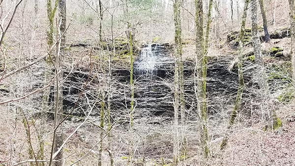
If you do the creekside route, then Cosmo Cascade is the first waterfall you’ll see. Leave the ATV trail at the creek. Then bushwhack along the hillside, down into the drainage, and along the creek. Once you reach the creek at the bottom of the hill, you’ll quickly reach Cosmo Cascade. It’s a nice 6-ft tall cascade along the creek. You might see this one on some apps or blogs as an unnamed fall. But on Gez’s Waterfalls in Arkansas map, you’ll see it as Cosmo Falls. He named it after his daughter’s golden retriever.
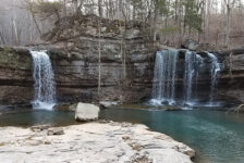
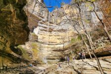
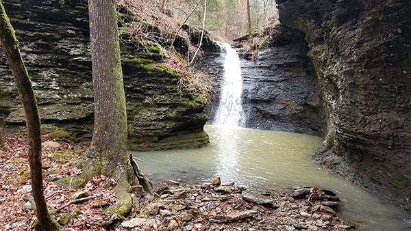
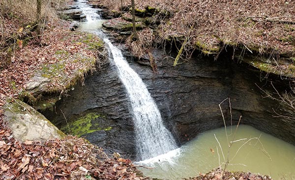
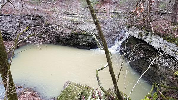
Green Grotto Falls
After Cosmo Cascade, the creek flattens out considerably. And as long as the water isn’t too high, you can walk the flat creekbed a few hundred feet to Green Grotto. The creek will cascade a bit to the top of Green Grotto Falls. It’s a really cool view from here, but be careful because it’s extremely slick. To reach the bottom, go down the right side along the top. About 30 yards down there’s a break in the bluffs where you can go down to the bottom. Then come back up the creek to the falls.
Green Grotto is an interesting grotto that turns into a narrow box canyon. It’s not extremely high – maybe 20-30 feet. But the way the sides of the grotto and bluff jut in and out looks so cool! And the rocks of the grotto all around the falls are lined with green moss. I’m guessing that’s where it got its name. Green Grotto is definitely the flagship waterfall of this hike. It would be worth hiking to all on it’s own. But if you’re already here, you might as well make the short walk on down to….
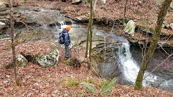
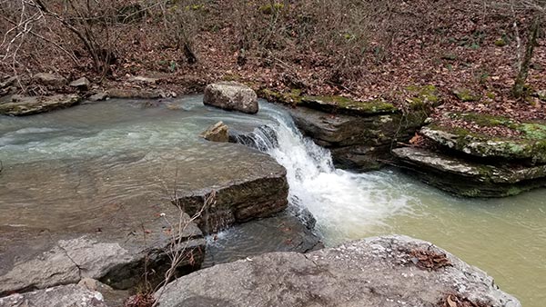
County Line Falls
From Green Grotto, just follow the creek on down until it runs into another creek. At that junction, you’ll see County Line Falls. It’s a small shelf waterfall along that creek. In fact, I’m kind of surprised it has a name. But it’s easy to reach and worth seeing. From here you would turn left and head upstream if you want to see the next one. It’s less than a half mile from here to Hotshot Falls. And it’s an easy bushwack walk down the creek. I mean, if you’ve made it this far, you might as well head on down to….
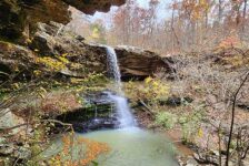
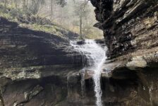
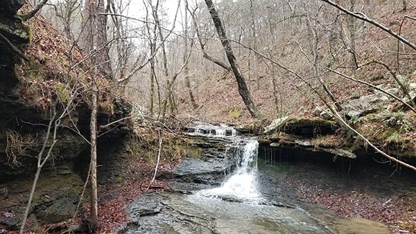
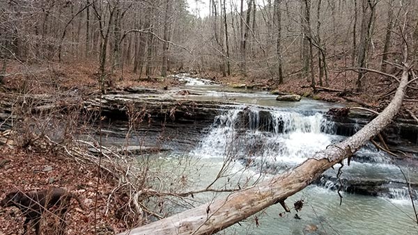
Hotshot Falls
Hotshot falls is so easy to reach from Green Grotto that it doesn’t make any sense to skip it. And there is another unnamed waterfall to see along the way. Hotshot is also a pretty impressive waterfall. This is a 12-15 ft waterslide type of fall that empties into a large pool. It is surrounded by cliffs that go straight up. It’s not a grotto that you can walk under. I would call it a bowl. But the bowl opens up into a canyon as the creek leaves the pool. It’s a really cool place to hang out. I could camp here.
From the pool, cross the creek on the right side (facing the falls), and there is a way up to the top. It’s a neat view of the creek and the top of the falls from up there. If you’re willing to walk up this creek another 500 ft, you can see another waterfall. You might as well, right? I mean you came this far and the next one is pretty cool. Might as well head a few hundred feet up the creek to…..
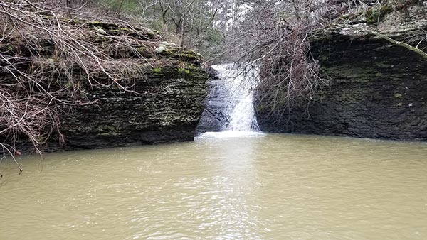
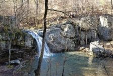
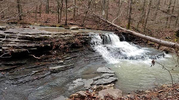
Wolf Den Falls
In my mind there is a little debate about whether or not this is Wolf Den Falls. I have a location saved in my Google map a little south of this that is labeled as Wolf Den. And I had no waypoints in my GPS for this spot. BUT our hiking friend Travis said it was Wolf Den. And I can’t imagine this waterfall being undiscovered and unnamed. It’s possible my Google map point was wrong and this is it. So I’m going with Travis Howk and calling this Wolf Den Falls. At any rate, it’s a cool waterfall, and worth the short walk from Hotshot. From here, it’s a tough walk up the hill to the ATV trail and back to the truck.
Plan Your Trip
Wow, after our morning hike and then this, that’s a full day of hiking! The creekside hike to Green Grotto Falls took us around 3 hours. It’s a long dirt road drive to get here, but the dirt roads are nice and 4WD is not needed. As I mentioned, you’ll want to do this hike in Winter or early Spring before it greens up, and while there’s lots of water. No matter which route you take, you’ll want to download a map or use GPS. I recommend using Gez’s gpx track that I have linked in the Quick Glance section. That will take you by all the falls I’ve described.
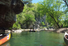
The hike to Green Grotto Falls is dog-friendly but not cell signal friendly. We crossed the creek several times, but never had water above the ankles. You’ll want waterproof boots for this hike, and extra socks just in case. I also recommend a hiking pole because you’ll walk over lots of rocks, up and down hills, and over slick spots. They’re great for moving briars aside too. Even though we did this hike in about 3 hours, I could easily spend more time here. So maybe take a hammock and some lunch. Just be prepared to pack out any trash you have and leave no trace. Both routes to Green Grotto are good. But if you make it that far you might as well see all the falls in these hollows. I hope you enjoy this hike.