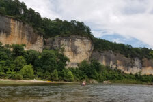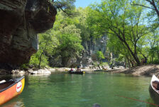
One of my favorite things about hiking with friends is seeing their reaction to some of the amazing sights in our beautiful state. Often times I’ll hike alone – intentionally – for my own mental health and to disconnect from everything. But other times, I like to have a hiking partner. This is especially true for more remote or difficult hikes where I’m not completely sure what to expect. So for a recent hike to Big Creek Cave Falls, I invited my long-time friend Neil Webb. Not because this hike is difficult, but because it is kind of remote. I wasn’t completely sure what to expect, but it ended up being a much easier hike than I thought.
Some of my hiking partners are used to seeing places like this. Others have done some of the basic popular hikes like Cedar Falls at Petit Jean or Lost Valley. And others have never seen much of this at all. These latter two are usually not prepared for what they’re about to see. And their reactions make every tough climb and creek crossing so worth it. Neil is an experienced hiker, but has not been to a lot of the places I like to go. After this hike though, Neil is asking “Where we going next?!”
Quick Glance
Distance: Approximately 4 miles out and back
Difficulty: Easy
Parking Coordinates: 35.876885, -93.159031
Second Creek Crossing: 35.872084, -93.157135
Trail Enters the woods along Big Creek: 35.869783, -93.156586
Trail Split to Rock Peninsula Falls: 35.86734, -93.15411
\Homestead and Vintage Cars: 35.86827, -93.15399
Trail Split/Cattle Crossing: 35.86721, -93.15363
Trail Split to Big Creek Cave Falls: 35.86335, -93.15321
Wolf Creek Unnamed Falls: 35.86265, -93.15121
Underground Falls: 35.86074, -93.15251
Wolf Creek Cave Falls: 35.860868, -93.152204
Abandoned Mine Shaft: 35.85954, -93.13522
Big Creek Cave Falls: 35.86318, -93.15447
Big Creek Cascade: 35.86390, -93.15437
(Copy/Paste Coordinates into GPS or Google Maps search bar)
Directions
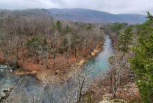
The hike to Big Creek Cave Falls is located in the southwestern-most hollow in what many people call the Arkansas Grand Canyon. This is located off Hwy 7 about 13 miles south of Jasper. There are two ways to reach the trailhead off Hwy 7. The first is shorter but is a rougher, steeper road. From the intersection of Hwy 16 and Hwy 7 at Deer, drive 1.4 miles north on Hwy 7. Turn right on Co Rd 59. It’s very easy to miss. Look for a blue road sign that says “6840”. This is actually Co Rd 59 on Google Maps. It is right next to a house and looks like a driveway on private property. But it’s not. Follow this road for 2.9 miles and look for a small clearing and parking area on the right. This is the trailhead.
The other way to get there is access Co Rd 59 from the other end further North. From Hwy 7 near the Arkansas Grand Canyon overlooks and B&B’s, look for McElroy Gap road. This road winds its way down the mountain into the canyon and eventually runs into Co Rd 59. It’s a smoother road, but longer route. Follow this road south the parking coordinates listed above. I recommend saving these coordinates and mapping yourself there.
What to Expect
The Hike
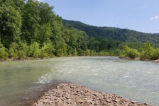
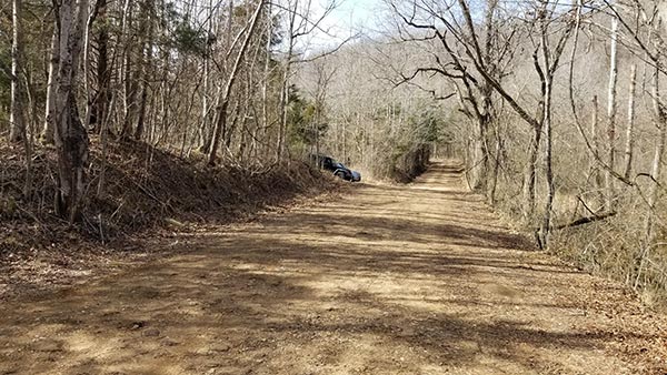
The hike to Big Creek Cave Falls and Wolf Creek Cave Falls is a little over 4 miles. It is an easier hike than I expected, with a clear and clean trail that is easy to follow. At least that’s the case during Winter, but could be different during growth season. There is no signage or blazes, but there are plenty of tree ribbons at important areas. This hike has a lot of features to see and a lot trail splits to figure out. So it’s a good idea to have a map or gps with waypoints saved. This hike is mostly level with no major uphill climbs. But we did have at least 5 creek crossings. We were able to rock-hop all but 2 and not get our feet wet. That number will vary up or down based on recent rainfall. Creek shoes are definitely recommended.
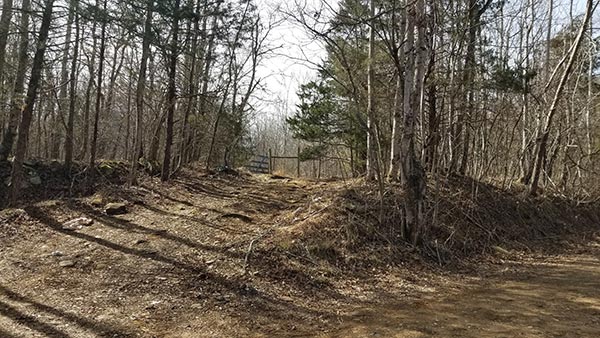
With all the trail splits, there are multiple ways to do this hike and see things in a different order. For our hike, we decided to go to Wolf Creek Cave Falls first, and then backtrack for the rest. Starting at the trailhead, proceed past the gate, and past the homestead. Follow the ATV trail down to the creek and cross it. Then keep following it across the first open field, another creek, and another open field. At the end of the second open field, the trail enters the woods and follows along Big Creek. All of these points are listed above. From here, just follow the trail. If you’re not sure where to turn, watch for ribbons in the trees. I highly recommend saving all these waypoints in a gps to help you navigate.


Side Features
There is a lot of cool stuff to see on the hike to Big Creek Cave Falls. Obviously, there are the two main attractions, Big Creek Cave Falls and Wolf Creek Cave Falls. You’ll also find some smaller falls along Big Creek as you enter the forest after crossing the two open fields. The coordinates for the turnoff to Peninsula Falls is listed above. After that, you’ll come to a trail split with a cattle guard across the trail. Turn left here to see the old homestead and vintage cars. I recommend seeing these on the way in, just in case you take the alternate trail out. (More on this at the end).
Just past the trail split to Big Creek Cave is a side trail that leads to the Wolf Creek unnamed waterfall. The coordinates for this waterfall are listed above. It’s a short walk to a cool grotto and worth checking out. Apparently there are several more waterfalls along this creek. But since this one was dry, we didn’t go any further. Finally, if you continue on past Wolf Creek Cave, you can find an old abandoned mine shaft. We weren’t that interested in it, so we skipped it. But I have the coordinates for it listed above if you want to check it out.
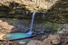
Wolf Creek Cave Falls
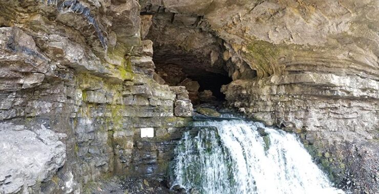
Following the trail on down to Wolf Creek Cave, you’ll cross the same creek several times. We found a downed tree bridge for one crossing, and rock-hopped the rest. After the last crossing, you’ll immediately hear a loud roar of rushing water. Keep following the trail and you’ll see the roar is from Underground Falls. This is formed by the creek leading out of Wolf Creek Cave. It empties into a sinkhole and continues on through an underground cave. It’s way cool! From here, follow the trail up the hill to Wolf Creek Cave.
Wolf Creek Cave Falls is pretty awesome. I actually liked it a little more than Big Creek Cave. I think that’s because the cave opening is bigger and closer to eye-level. So you can actually see up into the cave better. The cave is off limits for exploring in order to protect the bat habitat. So don’t even try it. Just enjoy the sights and sounds of massive amounts of spring water pouring out of that mountain.

Big Creek Cave Falls
After exploring the creeks around Wolf Creek Falls a bit, we backtracked the trail to the Big Creek Cave split. It was here we made our second crossing that required creek shoes. After that crossing, follow the trail going up the hill and you’ll immediately hear Big Creek Cave Falls. This cave is higher up the mountain and harder to see into. But it’s also a higher waterfall. It’s really cool to see the water pouring out of these mountain caves like this. You don’t see a whole of these cave waterfalls. Photo Tip: Cross the creek at the base of the falls and head up the other side of the for the best pics.
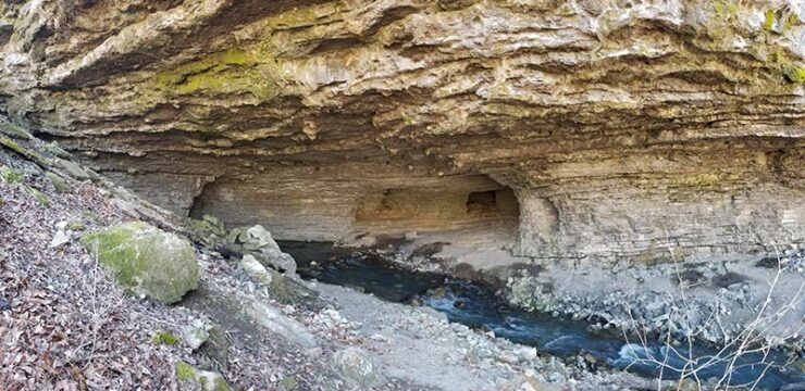
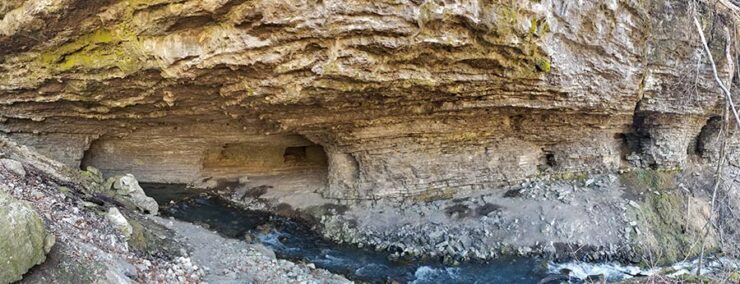
Big Creek Cascade
If you cross the creek at the base of Big Creek Cave Falls, the trail continues on around the bend. Keep following it this way and it will lead you to Big Creek Cascade. I was not expecting what I would see here. This yet another cave in the side of this mountain. But it’s the coolest looking cave on this hike. I don’t even know how to describe this cave. This one doesn’t actually have a waterfall in it. Instead, it has a creek flowing out of a dark cave that cascades on down the hill. If you don’t mind getting wet, you can cross this creek and wander up into the cave. It’s difficult to photograph so be sure to check it out in the video below.
Alternate Route
Leaving Big Creek Cascade, we crossed the creek coming out of it and continued down the trail. We did not cross back over Big Creek back to the main trail. Instead, we stayed on the trail following along the cave side of Big Creek. In other words, we were across the creek from the trail we first came in on. We looked for a creek crossing but never found a good one until we got past Peninsula Falls.
The trail we followed on that side was very well marked with tree ribbons. We eventually got off that trail when we found a good place to cross Big Creek. But that trail actually continued on towards the trailhead. I’m thinking it probably comes out at the first big field we crossed at the beginning of the hike. If so, then it bypasses the second creek crossing, which makes sense. Here are the approximate coordinates of where I think that comes out (35.871112, -93.158265). I’ve read about an alternate route and I’ll bet this is it. If anyone can confirm, please drop a note in the comments below.
Plan Your Trip
The hike to Big Creek Cave Falls can be done throughout most of the year. The cave waterfalls are not as reliant on rain as most other waterfalls. I don’t know that they’ll have water in the middle of summer, but they should be good for most of the year. Just be warned – from early Summer to early Fall, the grass in the big open fields might be pretty high. You’ll need lots of bug spray. But I imagine the creeks will be lower and easy to cross. Speaking of creek crossings, don’t forget your creek shoes for this hike. A hiking stick is handy too for walking on those slick rocks.
This is a pet-friendly hike. Cell phone service here is spotty. You may have it in some places, but maybe not when you need it. So be sure to download any maps, tracks, or waypoints you need beforehand. There are no restrooms, so if you’re not OK with going in the woods you better handle your business before you get there. If you are spending the day, bring food and water. But be prepared to pack out any trash you have and leave no trace. If you’re looking for an easier hike to some of the more unique waterfalls in Arkansas, this is a great one. Hope you enjoy it as much as we did!