I try to cover a variety of hikes that range in difficulty for hikers of all abilities. Sometimes I do an easy hike, and other times a more difficult hike. It just depends on what I’m in the mood for. If I’ve been stressed or too busy to plan a difficult hike, I might go for an easy one. Something on a well-travelled or well-marked trail I don’t have to think about. Hikes like Lost Valley or Kings Bluff. On the other hand, sometimes I’m in the mood for a challenge. I have a long list of these kind of hikes to do. The latest one I’ve checked off the list is the Bear Creek Waterfall Hike.
The Bear Creek waterfall hike has been on my list for years. When I first saw pictures of Sidewinder Falls and V-Slot falls, I knew I had to do this hike. I had the impression that it would be a really remote and difficult bushwhack hike. So I waited until my good friend David Colclasure could join me on this one. However, the more I researched, I discovered it’s not all that remote, nor is it a bushwhack. But as David and I would find out, this hike IS tough. But boy is it worth it
Quick Glance
Distance: Approximately 3 miles out and back
Difficulty: Hard
Parking Coordinates: 35.686872, -93.173709
Enter the Hollow from the field: 35.686548, -93.175972
Halfway Falls: 35.68703, -93.18121
Sidewinder Falls: 35.68935, -93.18483
Swamp Falls: 35.68926, -93.18494
Bluff Break between Swamp Falls and V-Slot: 35.68911, -93.18689
V-slot Falls: 35.68920, -93.18723
Bluff Break to Slot Pool: 35.68917, -93.18840
Goldilocks Falls: 35.68936, -93.18894
Slot Pool Falls: 35.68931, -93.18790
Baby Bear Falls: 35.69034, -93.18350
(Copy/Paste Coordinates into GPS or Google Maps search bar)


Directions
From Hwy 7 at Sand Gap, head west on Hwy 123 for 4.7 miles and look for CR 1802 on the left. That’s the trail. Once you leave Hwy 123, it’s all gravel road. But it’s a nice smooth gravel road that pretty much any car can handle. Drive 2.2 miles on CR 1802 until you see a clearing on the left side of the road. That’s the parking spot. From there, just walk about 40 yards further down the road and look for the logging road on the right heading into the woods. Coming from southwest (like Clarksville), come in on Hwy 123 through Hagarville. Follow Hwy 123 north past the one-lane bridge and up the mountain. Look for CR 1802 on your right.
What to Expect
The Hike
The Bear Creek waterfall hike is just a little over three miles round-trip, out and back. Most people, including myself, rate this hike as difficult. Half of the hike is actually pretty easy. That’s because it starts off as a level ATV trail. And when you hit the volunteer trail into the hollow, it’s all downhill to the creek. But there are spots along the creek that are not easy to navigate. And the hike back up the hill…well, it’s tough! And for that reason, it’s rated as a difficult hike.
The good news about this hike is that I would not consider it to be a bushwhack. Maybe it was a bushwhack years ago. But there’s been enough visitors here that the volunteer trail is actually a pretty good trail. It’s even marked with ribbons in a few places. However, I still recommend downloading a map and/or a gpx track and waypoints into a gps device. We didn’t need any creek shoes, but I could see them being necessary when the creek is high.
Getting to Halfway Falls
You’ll start this hike on a muddy ATV trail that will lead into a big open field. From here, you have to find where the trail leads into the hollow. So standing on the ATV trail where it first opens into the field, turn right and head for the back right corner. On the far right side, just past the treeline, you’ll see a swampy area. Just to the left of that is an opening in the brush. This is where the trail enters the hollow. (Coordinates listed above, and see this in the video below). Take the trail through this opening and start looking for ribbons in the trees.
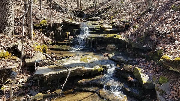
Congratulations, you have found the trail into the hollow! If you have a heart condition or mobility issues, stop and turn around right here. Because you are heading 700 feet down into a canyon that you’re going to have to walk back up. Still with me? Good, because it’s going to be worth it! Keep an eye on the creek following along the left side of the trail. Eventually you’ll see a noticeable cascade and small waterfall. This is halfway falls, and you’ve made it halfway to Bear Creek.
Sidewinder Falls and Swamp Falls
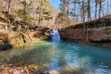
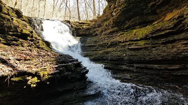
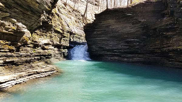
The creek following the trail is Swamp Creek. You can see other creeks converge with it along the way, making the second half of the descent very scenic. Swamp Creek empties into Bear Creek forming Swamp Falls. You’ll arrive at the top of that and follow the trail to the right. Immediately you’ll hear and see Sidewinder Falls. These two are only about 50 yards apart. From the top of Sidewinder, you get a good view of the box canyon below. There are two ways down to the bottom. One is to cross Bear Creek at the top of Sidewinder and carefully step down to the bottom of the falls. The other is to follow the trail back across Swamp Creek, and find the bluffline break on the other side.
For our Bear Creek waterfall hike, we chose to climb down into the canyon at the bottom of Sidewinder. This is the best view of Sidewinder Falls. Sidewinder is a waterslide type of fall that bends around the rocks, giving it the cool name. If Bear Creek is too high, it might not be possible to go this way. But for us, we were able to get to creek level and walk down to Swamp Falls. As I mentioned, Swamp Falls is created where Swamp Creek empties 20 ft over a ledge into Bear Creek. Check out the video further below to see these two falls and how we navigated this section.
V-slot Falls
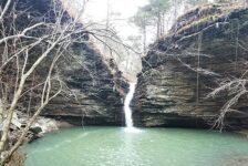
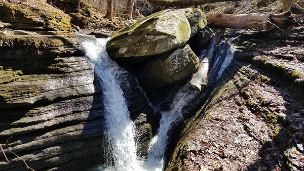
After Swamp Falls, continue down the creek less than 400 yards to V-Slot Falls. You will need to cross Bear Creek once or twice along the way. We were able to rock-hop and log-bridge across it and keep our feet dry. But if Bear Creek is too high, you might need some creek shoes. You’ll arrive at the top of V-slot Falls, and you’ll know you’re there because the creek kind of just disappears. There is a giant boulder in the middle of the creek and water diverts around both sides of it. This makes the waterfall take the shape of a “V”. It also forms the beginning of an awesome slot canyon. And so…you have V-Slot Falls.
There is a down tree right next to the boulder that looks like it will be there a while. We walked over the tree to the top of the boulder for a cool view. Please be careful if you decide to do this! On the bottom side of V-Slot is the best view. This is really a unique waterfall. From here, you can walk along the slot creek coming out of V-slot for about 50 ft to the top of Slot Pool Falls. Be very careful doing this! It’s very slick and a long drop to the pool down below. To reach the bottom safely, backtrack and find the trail along the top of the grotto. Watch the video below to see how we navigate this. The coordinates for the bluff break are in the list up top.
Slot Pool Falls and Goldilocks Falls
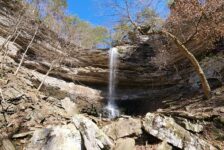
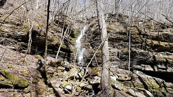
The trail goes about 100 yards past Slot Pool before it descends into the canyon. When you get to the creek level, resist the urge to immediately turn right and head to Slot Pool. Before you do that, turn left and go down the creek less than 50 yards. Look across Bear Creek and you’ll see an unnamed waterfall cascading down the hill. Rick Henry suggested “Goldilocks Falls” for this one and I like it. (Because it’s Bear Creek, and some of the falls have alternate names like “Mama Bear”, “Poppa Bear”, etc). After this, head back upstream into the canyon and grotto that forms Slot Pool Falls.
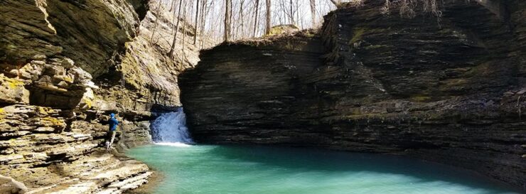
The Slot Pool grotto and canyon is pretty amazing. Especially if the light and water are right to give the water that emerald color we often see in the Ozarks. The waterfall is about a 12 ft cascade emptying into the pool from the slot creek above. We found some rocks in the sun to sit and have lunch on. If I had more time, I could have strung a hammock and stayed much longer. But there was more to see. Leaving Slot Pool, go back to the trail and follow it up the creek. Stay creekside until you find a bluff break close to Swamp Creek.
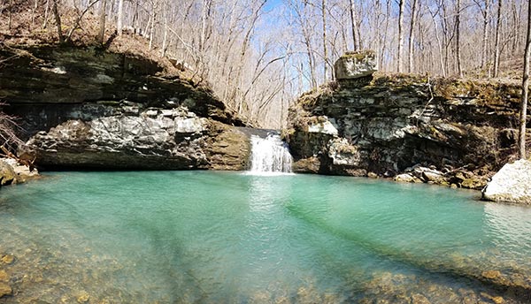
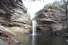
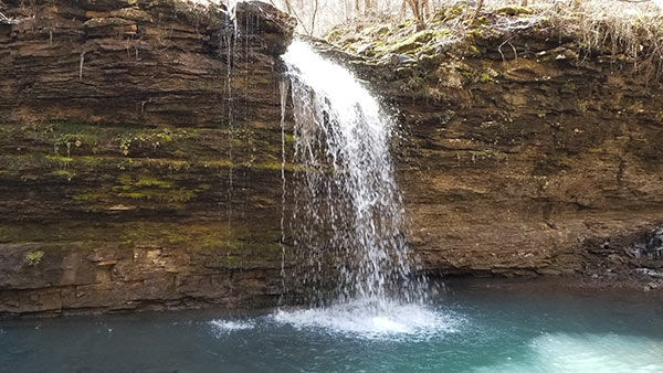
Baby Bear Falls
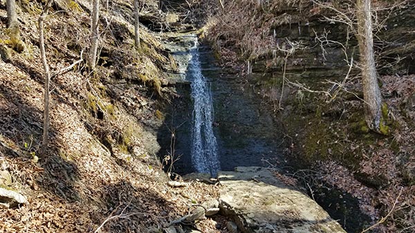
Once you get back to Swamp Creek, follow the trail again past Sidewinder Falls. From Sidewinder, it’s only about 200-300 yards up the creek to Baby Bear Falls. Whatever you do, DON’T skip this one. With a name like “Baby Bear Falls” you might think this is a small waterfall. Don’t let the name fool you though. This thing is gorgeous! It’s a decent size waterfall that empties into a huge pool of emerald green water. This is another place I could have hung out at for hours. Maybe the dread of the return hike up the hill had something to do with that. But the beauty of this place is mostly to blame.
Plan Your Trip
Our Bear Creek Waterfall hike took us about three and a half hours. That includes a lunch stop and a long break at Baby Bear Falls. Definitely give yourself 3-4 hours to thoroughly explore and enjoy this area. Cell service is spotty. You might have a signal in some spots, but don’t plan on having it when you need it. So download any maps, gpx tracks, or waypoints you need beforehand. And I DO recommend doing that for this hike because navigation can be tricky in some spots. There are tons of other hikes nearby if you want to fill out your day. That’s IF you have the energy after this hike. It’s pretty tiring. The closest hike is Buzzards Roost just down the same road. Another favorit of mine is the Pam’s Grotto hike down in the valley near Haw Creek.
There are no restrooms here, or anywhere nearby. In fact, there’s nothing nearby except nature. So pack any food or drinks you want to take. I do recommend taking some food. You’ll need the energy on the return hike. Just remember to pack out any trash might have and leave no trace. I also recommend a hiking stick and creek shoes, just in case Bear Creek is high. If you have all day, you might want to pack a hammock. There are plenty of good spots for it. And this is a dog-friendly area if you want to take your pup. This hike is definitely one of my new favorites. If you are up for a challenge, then I highly recommend it. Just don’t cuss me when you’re hiking out of there! I hope you enjoy this hike as much as we did.