
Hello everyone! My name is Travis, and I’m a new member of the AROwnBackyard team. I’ll be sharing tales of trails around Arkansas to help all of you discover your next outdoor adventure. This past week, I undertook a bushwhack to Greasy Creek Falls, as well as several of its waterfall friends in the nearby area!
One of my dear friends, Gez Rogers of Waterfalls in Arkansas, has compiled an excellent map of waterfalls around Arkansas. For quick reference, you can always find this map on the AR Own Backyard hiking page. Although it already contains hundreds, some waterfalls haven’t managed to make it to the map just yet! After all, Arkansas has many excellent hollows, gaps, and canyons not fully documented. For me, these chunks of this wilderness make for an ideal weekend hike.
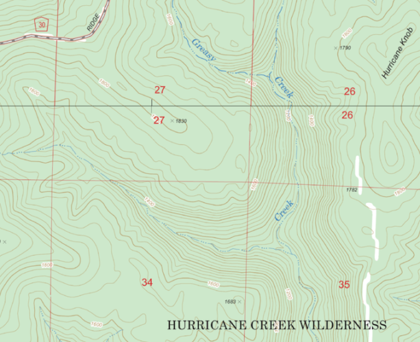
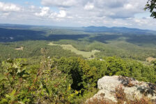
While staring at the waterfall map last week, I noticed a gap in documented falls just south of Deer, AR in the Hurricane Creek Wilderness. I immediately found this unusual. The region between Sand Gap and Ozone has a plethora of incredible falls, yet there was a blank slate on the map. Just west of Hurricane Knob, my eyes settled on a stream called “Greasy Creek.” Everything about the topography screamed, “Waterfalls here!” I knew I had to go.
Whenever I’m looking to start a bushwhack, one of the first things I do is look for routes that others have taken. Both AllTrails and GaiaGPS offer excellent features that allow users to see paths others have forged. To my surprise, I only found a single trail through the area. A user named dlhale had traveled the fork in early March. Judging by the jitters in his GPS recording, there were at least three notable falls along the route.
To reach the creek, I drove 6 miles south from Deer along Co Rd 30. The dirt road was 2WD friendly enough that I made it without issue. You’ll know you’re at the right spot if you see a peculiar metal fence setup belonging to the USFS. My route began along the traces of what I believe was an old forest road. I followed it for a few hundred feet before cutting downhill at the first signs of water. I’d be “going in creekside,” to quote Gez.
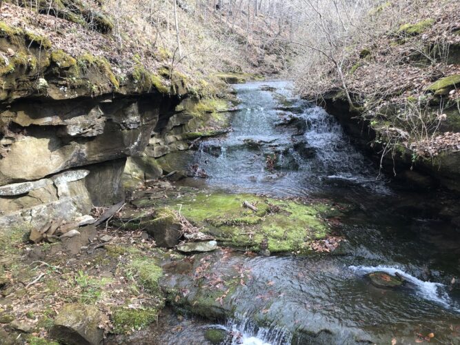
As a waterfall hunter, it is typically sensible to go where the water goes, especially when there is no trail to follow. I’ll gladly trade the increased chance of getting wet for less brush to push through. It proved to be a good decision for me on this journey; within a quarter-mile of my journey downstream, the creek began to sport a series of small cascades, each about a foot high. About 0.7 miles in, my creek merged with another from a northern fork, forming the titular Greasy Creek I’d follow for the rest of my journey.
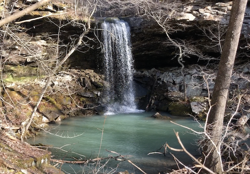
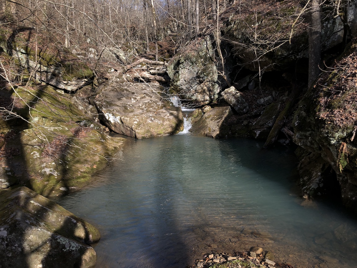
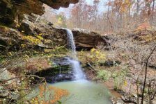
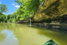
I could hear the roar of the falls well before I reached them. The creek soon disappeared from view over a 30-foot drop, crashing into an aquamarine pool. I worked my way along the southern rim of the falls before finding a point to descend slightly downstream. I’d later learn from Jeff Johnson of Arkansas Nature Lovers the name of this beauty: Greasy Creek Falls. A fitting name for the best waterfall on the creek! Also, a huge shoutout to Jeff for sharing some information about this region with me; he’s a go-to guy for info about this part of the Ozarks!
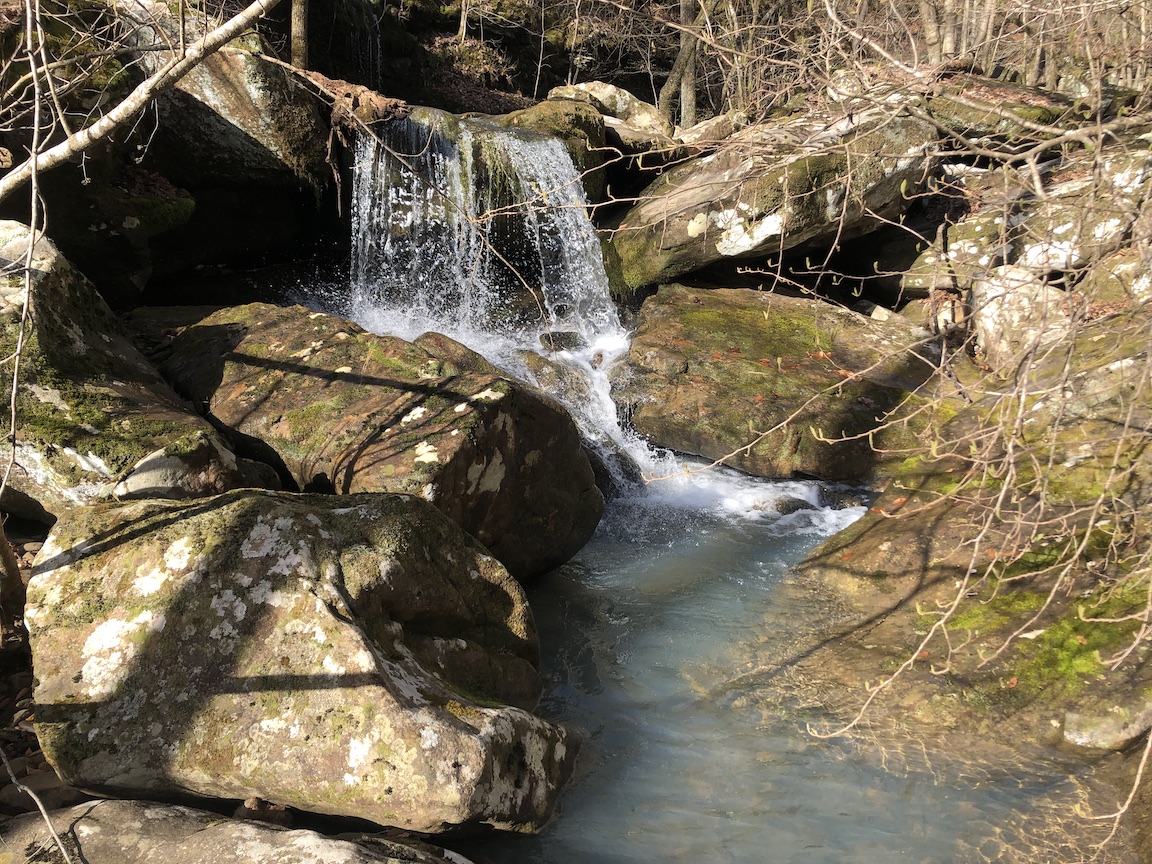
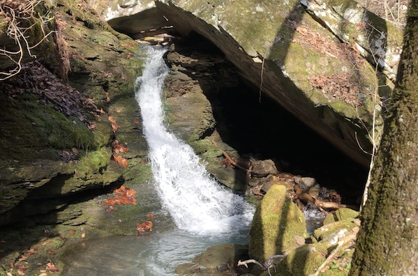
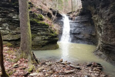
Beneath the falls, I continued my descent, encountering several lesser falls. None were quite as impressive, but each still shared its charm. My personal favorite is one I dubbed “Mossy Tent Falls,” a split waterfall half obscured by a van-sized boulder.
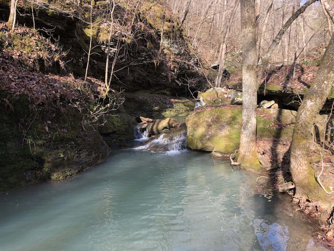
While I’d say the route to reach Greasy Creek Falls is more of a moderate bushwhack, the area beneath I’d find hard to categorize as anything other than difficult. The Hurricane Creek Wilderness is frequently punctuated by impressive rock gardens full of massive boulders. These make traversal challenging at best and dangerous at worst. There were multiple descents with an unclear route forward, and the slippery rocks certainly didn’t help make things any easier.
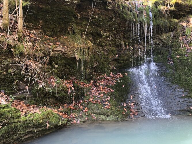
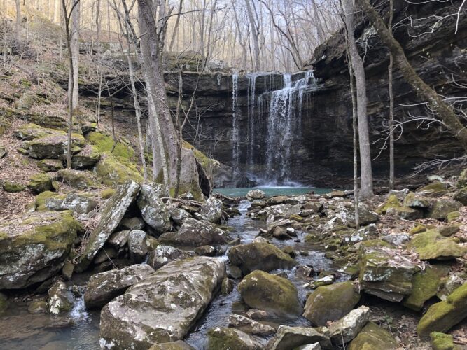
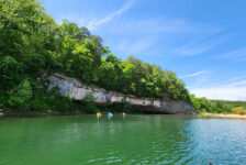
1.5 miles in, Greasy Creek combines with a stream from the north. Here you’ll find another beautiful waterfall, Pellham falls, named after the family that lived on this land in the early 1900s. Cresting the ridge between the forks, I found traces of a stone wall that likely served as a fence for their property. A further 500 ft north comes the second most impressive falls of the trip: Misty Falls. Nestled in the cooler cove against this impressive cliffside, I chose this spot to take a brief break before beginning my ascent out of the valley.
Despite my love of hiking, ascents are rarely a favorite of mine. They are, however, a necessary part of getting to see some of the best scenery in the state. Aiming to reach the ridgeline as quickly as possible, I ascended straight uphill, or as close as I could manage. I climbed 500ft in a little more than 0.3 miles (something my legs were none too happy with the following day). Breaking through a gap in the cliffs, it was a further half mile to reach the traces of the original forest road, which carried me the rest of the way back to my vehicle. For one last surprise, I found myself startled by a large feral hog, who quickly ran off into the brush before I could manage a response.
For many hikers, the solitude that comes with the great outdoors can be quite refreshing. I’m certainly no different. One of my favorite aspects of bushwhacking is the discovery that comes with exploring an area where you don’t know what lies around every corner. Greasy Creek provides a challenging yet fantastic setting for several excellent waterfalls, and I’m confident that I didn’t learn everything this hollow had to offer. Some further research in my time since the hike revealed at least one great waterfall further downstream. I’ll certainly be returning in the future to see what else I can find!
Greasy Creek Falls Bushwhack at a Glance
Distance: About 3.5 miles in and out.
Difficulty: Greasy Creek Falls is reachable with a moderate bushwhack. All others I would consider a hard bushwhack.
Route and Waypoints: The trailhead starts at 35.75525, -93.21339. Specific falls can be found in the AllTrails recording here.
Driving Directions: See Google Map below.
As always, make sure to both #leavenotrace and #packmoreout to help ensure we keep this beautiful state clean!
Travis Howk is an amateur writer and hiker from North Little Rock, Arkansas. When he’s not out on the trail or spending way too long looking at maps for new trails, you can find him at home with his newborn, playing board and video games, or spending far too much time on Wikipedia.

Doug Kahler
I have been to Greasy Creek near Deer, Ar. and it was definitely a bushwhacking hike but well worth the terrain. It was approximately 6 miles roundtrip