When it comes to good places to see Fall colors in Arkansas, I have a short list of locations that immediately come to mind. First, it is really hard to beat Sam’s Throne this time of year – both the drive and the short hike. Next, for hiking to see Fall colors, I really like Buzzards Roost a lot. Those two locations are up in the Ozarks near Mt. Judea and Sand Gap. For people near Central Arkansas that want something closer, one of my best recommendations is a drive to Flatside Pinnacle. And if there has been any recent rain, maybe add a stop at Brown Creek Cascade.
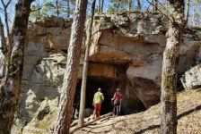
The Flatside Pinnacle Vista is located in the Flatside Wilderness area in the easternmost part of the Ouachita Mountains. This vast wilderness area consists of 10,000 acres to the west of Lake Maumelle, and east of Hwy 7, north of Jessieville. It encompasses numerous creeks, mountains, trails, and panoramic views. Notable sites include Lake Winona Vista, Crystal Mountain Vista, and more. Lake Winona, Lake Sylvia, and Oak Mountain Vista are also close by, although not within the official boundaries of the Flatside Wilderness. On the west end of Flatside Wilderness is Forked Mountain and Forked Mountain Falls, which I have visited once. This remote wilderness may be void of much noise, but in the Fall, it is full of color. And it has plenty of vantage points to give you some great views of it all.
Quick Glance
Hiking Distance to Vista: Approximately 0.2 mile out and back
Flatside Pinnacle Vista Parking Coordinates: 34.874569, -92.913604
Difficulty: Easy
Hiking Distance to >Brown Creek Cascade: Approximately 200 yards out and back
Brown Creek Cascade Coordinates: 34.865402, -92.889212
Lake Winona Vista: 34.836858, -92.925122
Crystal Mountain Vista: 34.838138, -92.936671
Oak Mountain Vista: 34.821782, -93.025250
Forked Mountain Vista: 34.833052, -93.026218
(Copy/Paste Coordinates into Google Maps search bar)
Directions
There are many different ways to get to Flatside Pinnacle. It just depends on where you’re coming from. I could fill up a whole page with all the different routes, so I’ll just describe two. The fastest way there from Little Rock is to take Hwy 10 west past Lake Maumelle. After the intersection at Hwy 9, look for the sign to Lake Sylvia. Turn left at the sign onto Hwy 324. From here, you can take Browns Creek Rd (aka Co Rd 55) if you want to stop at Brown Creek Cascade. It’s also the fastest way. But the road is pretty narrow and rough going up the mountain. Another way is to stay on Hwy 324 all the way through the Lake Sylvia Rec Area. That turns into a gravel road (Co Rd 58). It’s a little rough at first but it gets better pretty quick. From here, just turn right at every fork until you see the sign at the parking area. Coming from Conway will be slightly different. And obviously, coming from the west side, off Hwy 7, will be completely different. So use the coordinates above or the Google map below to navigate from your location.
What to Expect
The Flatside Wilderness is a vast and remote area of mountainous timber land. It is managed by the U.S. Forest Service and protected under the Arkansas Wilderness Act of 1984. You will find an extensive labyrinth of Forestry Service roads, some trails, and shelters. Outside of that, you will not find much development here. That includes cell towers. So if you need to stay connected to the world, this is not the place for you. Once you leave Hwy 324 onto any of the gravel roads entering Flatside Wilderness, you will be on gravel roads for quite a while. Some of these roads are pretty good, and some of them are pretty rough. One could easily spend a whole day just driving these roads. With no cell service, it’s important to have a reliable vehicle with a full tank of gas and a good spare tire.
During the Fall there is a good chance of seeing a lot of deer hunter camps set up near the roads. Wear hunter orange if you venture deep into the woods. Steer clear of people’s deer camps and don’t make too much noise. This is also a popular spot for gravel bike racing, trail running, and ATV riders. So keep an eye out for them on the roads.
Flatside Pinnacle
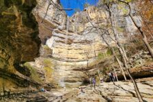
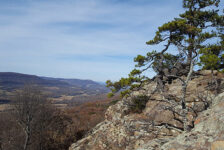
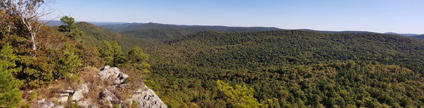
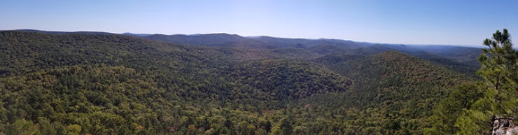
Flatside Pinnacle is a 1,550 ft peak with incredible panoramic views. Don’t worry, it’s not a 1,550 ft climb. In fact, driving down the gravel road to the trailhead takes much longer than the hike itself. The hike from the road up to the vista is very short, only 0.2 miles. It is a clear trail that is easy to follow. The trail is uphill most of the way and gets rocky and steep at the end. I would not consider it difficult, but will be a problem for anyone with mobility issues.
Once at the top, you’ll be treated to some of the best views in the state. If you study the maps at all or are familiar with any of the nearby peaks (you can find them all here), then you’ll be able to pick out many from Flatside Pinnacle. The closest and most obvious one is Forked Mountain to the west. You can also see Pinnacle Mountain and Rattlesnake Ridge to the east. If you know what to look for, you should be able to pick out Mt. Nebo and Petit Jean. And on a very clear day, you might be able to see Mt. Magazine.
Like I said, it’s a short hike up, which leaves you plenty of time to hang out at the vista. It’s a great spot to hang a hammock, have lunch, or just sit on a rock and meditate. You’ll likely hear nothing but the wind blowing. Whatever things you decide to take up there, make sure a camera is one of them. There are some high, dangerous ledges at the vista. Keep an eye on your kids and keep pets on a leash. A fall here could be deadly.


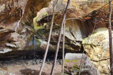
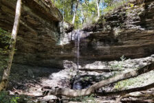
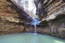
Brown Creek Cascade
If you take the Brown Creek Rd route to Flatside Pinnacle, you might as well stop at Brown Creek Cascade. It’s not a big, impressive waterfall. But when there’s water, it is a pretty area. Besides, it’s only a 200 yard hike off the road on a clean, easy trail. So why not stop and check this one off the list?
To reach Brown Creek Cascade, turn right off Hwy 324 into Brown Creek Rd. At exactly 5.3 miles, look for a clearing on the left and park there. At the back left corner of the clearing (when facing away from the road) find the trail leading into the woods. Follow this trail across two small creeks approximately 200 yards. Keep looking to the left for a clear path to the creek. These steps are featured in my video below, so give that a look.
Plan Your Trip
As I mentioned before, there is no cell service here…anywhere…NONE. So there’s a few things you should do before you go. One – Download any maps you need and save any sites you want to visit into your Google map or GPS. Two – If you plan to visit other sites or explore Flatside Wilderness, make sure you have plenty of gas and a spare tire. You’ll do a lot of driving on long gravel roads, with no cell service. It’s not a good place to break down. And it’s not an ideal area for small cars, so plan accordingly. Three – tell someone where you’re going.
It would be easy to spend a whole day in the Flatside Wilderness. In addition to Flatside Pinnacle, there are other vistas, such as Lake Winona Vista, Crystal Mountain Vista, and Oak Mountain Vista. Or maybe you would like to climb Forked Mountain or see Forked Mountain Falls. Also, the Ouachita National Recreation Trail meanders all the way across Flatside Wilderness on it’s way to Oklahoma. This would be a good overnight hiking option. Take food and plenty of water when you visit this area. Be prepared to pack out any trash and leave no trace. There are no restrooms close by, but you can find all the privacy you need in this remote wilderness area. If you are near Central Arkansas and haven’t explored Flatside Wilderness, you should add it to your list.