It was a random Sunday drive up Hwy 7 into the Ozarks years ago where I unexpectedly found my future playground. Little did I know at the time that a visit to Haw Creek Falls would lead to this rabbit hole of adventures that I’ll likely never find the end of. Haw Creek would lead to Pack Rat Falls and Pam’s Grotto. And then across Hwy 7, I would find Kings Bluff and Pedestal Rocks, which would lead me to Falling Water Creek. And from that point, I was hooked. Oh I had done some mountain biking, some paddling, and your basic State Park hikes. But nothing like the Ozark gems I would find all up and down Hwy 7, and eventually all across the state. Since that day, I’ve travelled along this highway countless times, often not knowing what other gems I was passing right by. One of those gems I recently got to check off my list was a hike to Hudson Shelter Falls.
I had actually known about Hudson Shelter Falls for a while, and even went to hike it a year prior to this time. But that first visit was too early in the Fall, and the creek was bone dry. And that’s the deal with Hudson Shelter Falls – you have to catch it during wet season or right after a rain. If you do, you’re in for a treat. Because this is a short, easy hike with a huge payoff.
Quick Glance
Distance: Approximately 0.7 miles out and back
Difficulty: Easy
Parking Coordinates: 35.85417, -93.12635
Upper Falls: 35.85151, -93.12414
Lower Falls and Cave: 35.85144, -93.12410
GPS Track: Click Here
(Copy/Paste Coordinates into GPS or Google Maps search bar)
Directions
On Hwy 7 between Jasper and Sand Gap/Pelsor, look for Nfm 1204 (aka CR 55) on the east side of the highway. It is 11 miles north of Sand Gap and about 17 miles south of Jasper. Once you turn on Nfm 1204 (aka CR 55), drive 4.1 miles and turn right on Hudson Mountain Rd. Just over 400 ft down the road, the parking area is on the right. Google map is below with the parking area marked. From there, walk about 50 feet down the ATV trail and the hiking trail starts there. See video below.
What to Expect
The Hike
The hike to Hudson Shelter Falls is a short out-and-back trail that is only 0.7 miles round-trip. It is not a well-marked trail as far as signs and tree blazes go. In fact, there are none. But the trail is easy enough to follow without them. At the beginning, it is a clear and obvious path from the trailhead down to a very small creek. But as you reach the creek, the trail disappears. Turn right and follow the water. What I quickly realized is that this tiny creek actually IS the trail. The water flows down the trail until it forms an actual creek. At that point, you’ll once again find a clear trail that picks up and runs alongside the creek. You will cross this creek once or twice before reaching the falls. These are dry crossings, no water shoes are needed.
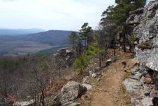
As you get closer to the falls, you’ll catch some gorgeous views of the surrounding valleys and mountains. The creek will look like it’s falling off the edge of the Earth, and that’s when you’ll know you’ve reached the top of the falls. From start to finish, there’s around 200 feet of elevation change as the trail descends down the side of Hudson Mountain. Which means you’ll have 200 vertical feet uphill on the way out. Don’t worry, it’s not too steep or difficult. Just enough to get the heart pumping. Overall, I would rate this as an easy hike.


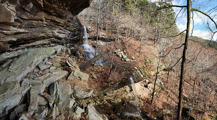
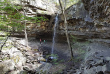
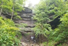
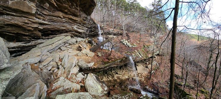
Waterfalls and Cave
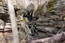
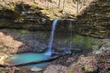
Hudson Shelter Falls is a series of waterfalls that pour off the ledges of Hudson Mountain. There are two main waterfalls in the cascade and a small one at the very top of it. You’ll see the first small one at the top before the first pouroff. Stay on the trail to the left as it winds down to the bottom of the first main waterfall. From there, make your way across the ledge at the bottom of the falls, crossing the creek again before it pours off the next ledge. This will take you along the bluffline on the other side. From there you can traverse the boulders for a great view of both waterfalls. The second waterfall pours over a ledge with a gigantic cave beneath it.
From the vantage point under the bluffs, you can scramble down the rocks to the bottom of the second waterfall. This is also the way into the gigantic cave at the bottom. As far as I know, there’s not much else to see after the cave. Although the bluffline looked like it was worth exploring. I did see what looked like another small cave as I was perched on the rocks admiring the view of the falls. The view of the falls from there is absolutely amazing. I felt like the hike to it was way too easy for such an awesome sight. I could have spent much more time there, but I wanted to give myself enough time for my next hike.
Plan Your Trip
The hike to Hudson Shelter Falls can be done in less than an hour, not counting time spent hanging out at the falls. It is a dog-friendly trail, but keep them leashed around the top of the falls. And keep an eye on kiddos on top of the falls as well. Don’t let them get too close to the ledges. There is no cell signal here. You lose service about a mile or so off Hwy 7. If you follow these directions and watch the video above, you won’t need a map or GPS. But it never hurts to have the GPS track downloaded. There are no restrooms close by – but who needs one of those in the woods? There are also no trash cans, so be prepared to pack out any trash you might have and leave no trace.
Since the hike to Hudson Shelter Falls is a short one, you might want to pair it with one or two other hikes to fill out your day. There are several other hikes close by to choose from. My recommendation would be to start with Fern Falls, which is on the west side of Hwy 7, just 13 miles north of the road to Hudson Shelter. Then I would work my way down to Hudson Shelter and then Lonesome Hollow Falls, less than a mile south on Hwy 7. I’ll have an article on Lonesome Hollow in the upcoming weeks, so stay tuned. Another option would be the Big Creek Cave Falls hike. The road to Big Creek Cave Falls is just 8.5 miles north of the road to Hudson Shelter, off Hwy 7. It’s a little longer hike (4 miles), but both could be done in a day if you start early. There are many other hikes in the area, but these are the closest. Next time you’re on this section of Hwy 7 after a good rain, go check out Hudson Shelter Falls. Enjoy the hike!