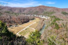
Boxley Valley is one of the most iconic areas of the Ozarks. This scenic spot near Ponca attracts thousands of visitors per year to view the elk herds and hike the Upper Buffalo area. And that doesn’t even count the thousands of Buffalo River paddlers each Spring. This area has an abundance of fantastic hiking destinations for hikers to choose from. One of the most popular is an area tucked away in a hollow of Boxley known as Lost Valley. Anyone that has hiked much around the Upper Buffalo has likely hiked to Eden Falls at Lost Valley. But not everyone knows about Armadillo Falls and Eden Cave.
The main attractions at Lost Valley are undoubtedly Eden Falls, Cobb Cave, and the Natural Bridge. I’ll admit, the first time I visited Lost Valley, I didn’t know there was anything else. My second visit was on a freezing cold day where I was the only person in the park. I skipped Eden Cave so I could hike out just before the forecasted rain. But I was determined to come back under better conditions to explore the cave. So for my last visit, my hiking pals and I explored Eden Cave and completed the short bushwhack to find Armadillo Falls.
Quick Glance
Parking Coordinates: 36.008887, -93.371312
Armadillo Falls Distance: Approximately 0.5 miles out and back
Armadillo Falls Difficulty: Moderate-Difficult
Cross Clark Creek to Armadillo Falls: 36.01247, -93.38139
Lower Armadillo Falls: 36.01514, -93.38088
Upper/Middle Armadillo Falls: 36.01560, -93.38092
Lost Valley Main Trial Distance: Approximately 2 miles out and back
Lost Valley Main Trail Difficulty: Easy
Eden Falls Cave Difficulty: Moderate-Difficult
Eden Falls Cave: 36.01782, -93.38788
(Copy/Paste Coordinates into GPS or Google Maps search bar)
Directions
There are so many ways to get to Lost Valley from all over the state. So to make it simple, just map yourself to Ponca. From there, find Hwy 43, which runs right alongside the Buffalo River. You will find a sign for the Lost Valley Trailhead on Hwy 43. If you are coming from the south, you will see this sign before you get to Ponca. Follow that road to the parking area and you’re there.
What to Expect
Armadillo Falls and Eden Cave are both some of the more extreme and hard to reach features in Lost Valley. Armadillo Falls is a light bushwhack until you get to the upper reaches of Armadillo Creek. Then it becomes a more difficult bushwhack in some pretty rugged terrain. As I’ve mentioned in other articles, don’t let the term “bushwhack” scare you. All it means is that you’re hiking without a trail. In this case, the bushwhacking does become somewhat difficult at the end. As for Eden Cave, it requires crawling and squeezing through some tight spaces. It’s also very dark, wet, and slippery.
Armadillo Falls Hike
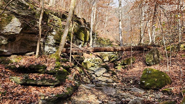
From the main trailhead, follow the trail along Clark Creek for just under half a mile. Look for a placard sign on the right side of the trail. Just a little past that, you’ll look to the right and see a feeder creek or dry creek bed on the other side of Clark Creek. Use the coordinates listed above to be sure. The feeder creek on the other side of Clark Creek is Armadillo Creek. This is the beginning of the bushwhack hike. From this point, the creek is your trail and it is around 0.25 miles each way. Check out the video below to see all the turns as we navigate up Armadillo Creek.
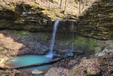
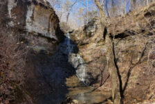
Along Armadillo Creek, you’ll pass by some cool rock formations until you reach a fork in the creek. The water flow is noticeably greater here, and you’ll notice things are getting steeper. Take the fork to the left, and soon you’ll go up a little waterslide cascade. Right after that you’ll reach a very unique grotto cave. Walk under this grotto and the first waterfall will be at the end. This is a really unique grotto and waterfall, and these alone are worth the hike to this point. If you’re up for more of a challenge, go up the right side of this waterfall and continue up the creek.
Armadillo Falls
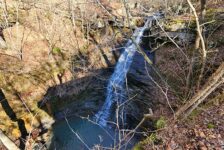
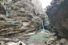
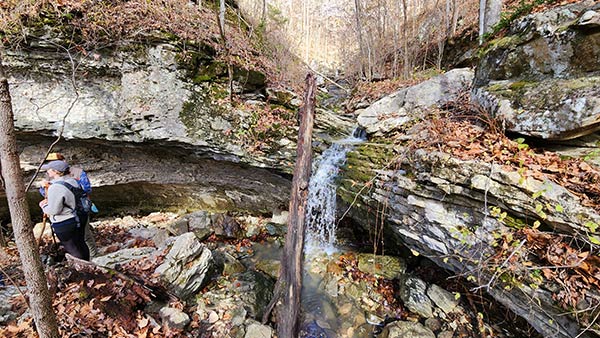
After the waterfall at the cave grotto, the hike gets steeper and a bit sketchy. A hundred yards or so up the steep incline, you’ll reach a second grotto. This is Lower Armadillo Falls. Let me tell you, it’s a super cool one! The creek flowing from above it pours over the top of the grotto into a pool, then continues on downhill. BUT, there is a second water fall in this grotto. And it’s coming from a small cave in the side of the mountain! So it’s a double waterfall – one inside the grotto, and one flowing over it.
Now…if you’re really feeling adventurous, you can keep going just a little further up. On the left side of the grotto, you can make your way up the side of the mountain to the base of the bluffs. It is very steep, but it flattens out into a narrow shelf. Be very careful up here! It’s very steep, but there are trees to hold onto. A fall here would probably not be fatal, but it would not be good. Continue on past the top of Lower Armadillo Falls until you see the next waterfall straight ahead. From this point, you get a great view of Middle Armadillo Falls. This is where we stopped. The bluffs forming that waterfall were straight up and down on both sides of the falls. Getting past these would be extremely risky – well past my risk tolerance.
From this point, you can see how the creek canyon zigzags up to the very top of the mountain. And through the trees, you can see more waterfalls way up in the canyon as the water winds down through it. This is Upper Armadillo Falls. Unfortunately, getting to those looks quite hazardous. Though I did see a road on Google maps that looks like it gets close to the top of the canyon. But I don’t know if it is public or not. The really cool thing here is turning around (back towards Clark Creek) to realize that you are now up higher than most of the treetops in Lost Valley. That you are now standing next to the large bluff face you can see when you are hiking along the main Lost Valley trail.


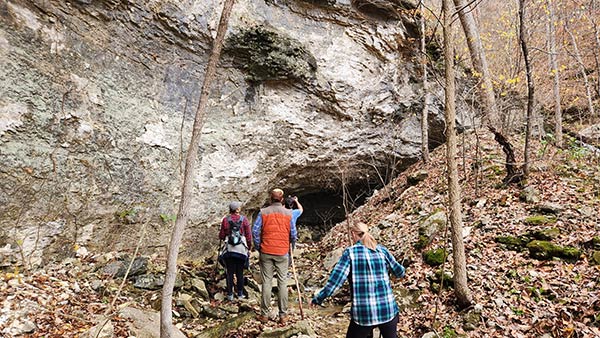
Eden Cave
After coming back down Armadillo Creek to the main Lost Valley trail, continue on to Eden Falls. This is an easy hike along the main trail. Go up the trail past Lower Eden Falls, following the signs to Eden Falls Cave. When you reach the cave entrance, be very careful stepping down into it. The rocks are extremely slippery. And a fall here would not be good. Once inside the cave, you’ll definitely want a headlamp. And I recommend taking off any backpacks and leaving them at the first fork, because things are going to get tight.
At the fork inside the cave, you can go right or left. I recommend going RIGHT. Going left means crawling 10-15 yards under the rocks in about 30 vertical inches of space. At the end of that, on the right side, there is a narrow hole to stand up and crawl out of. I’m getting claustrophobic just thinking about it. Once up, you’ll be in a very narrow and winding corridor. The bad news is, it’s very close quarters. The good news is, you can stand up and it’s only about 10-15 steps. Then it opens up into the big waterfall cave room.
Going to the right at the previously mentioned fork is the way to go. It’s a very narrow and winding corridor the whole way, but at least you can stand up through it. You’ll pass right by the hole that we crawled out of when we went to the left. So you get to skip that nightmare. And onward you go to the big waterfall cave room. Good luck getting pictures of the waterfall. (Tip: go with a group and have everyone point their lights in different directions to illuminate the whole cave.) My photos did not turn out good enough to include in this article. But I did figure out that video actually captures the waterfall better than photos.
Plan Your Trip
Give yourself at least two hours to hike both Armadillo Falls and Eden Cave. Or roughly an hour each. I recommend using a GPS for Armadillo Falls, and save the waypoints listed up above. Some solid hiking boots or trail shoes are recommended for that hike. I don’t recommend this hike during hot weather as the creek will likely be dry, and it is a bushwhack. There is no cell service anywhere in Boxley Valley, including Lost Valley. So save any maps or waypoints before you go, and make your last calls and texts before you enter the valley. Lost Valley is managed by the National Park Service, which unfortunately means dogs are not allowed here. So plan accordingly. If you are only doing the main Lost Valley Trail and Eden Cave, then GPS and maps are not needed. But you WILL need a flashlight – preferably a headlamp – for Eden Cave.
Lost Valley has public restrooms located at the trailhead. Those are also the only trash cans, so be sure to pack out any trash you might have and leave no trace. There are two outfitter stores a mile away in Ponca that sell food, drinks, and random supplies. Visitors can find restaurants in nearby Jasper and Low Gap, just up Hwy 74 from Ponca. There are tons of other hiking trails and float options in the area. Click here for a list of all the hikes and floats I’ve written about so far in the #upperBuffalo area. There are many more than this, and I’ll keep adding to this list when I can.
You can easily spend a week exploring all the adventures the Upper Buffalo area has to offer. If you want to spend multiple days exploring, there are plenty of places to stay. NPS campgrounds are at nearby Steel Creek and Kyle’s Landing. And several other private campgrounds pop up on a Google Maps search. There are definitely more cabin and vacation rental options in the area than campgrounds. From Ponca to Kingston, to Compton, to Jasper, and everywhere in between, you’ll find plenty of options. More than I can list here for sure. But a search of VRBO, AirBnb, and Google Maps will provide a wide variety of rental options for you. These fill up quickly during certain times of the year, so plan ahead. Be safe out there, and enjoy the hike!