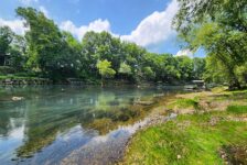
The Brock Creek Trail Area and other hollows near Lost Corner are a waterfall hunter’s paradise. This area is well-documented by waterfall pioneers like Tim Ernst and the late Rick Henry, among others. A look at the Waterfalls in Arkansas map will show you just how chock full of waterfalls this place is. Some of these waterfalls – like Schoolhouse Falls – can be accessed via easy hiking trails. Others, like Brushy Grotto Falls and Green Grotto Falls involve some trail and some bushwhack hiking. Many of them have multiple ways you can reach the falls. Hiking to Lizard Log Falls is one of those.
Lizard Log Falls is a hike that I attempted to do two years before this writing. I got a little confused that day because the GPS track I had saved did not jive with the trail I was on. I wasn’t sure how long to stay on the trail, and where to leave it to bushwhack to the falls. It was one of several times I’ve had to learn the hard way to do my homework before the hike. I recently had an opportunity to join my friends Gez Rogers and Super Leeds of Waterfalls in Arkansas, for another hike. We did the Brushy Grotto hike together a year prior to this. So this time, we opted for Lizard Log, which is one they have done several times. Gez is the creator of the Waterfalls in Arkansas map. It’s a really awesome Google map with over 500 locations marked for waterfalls and parking. If you like to hunt waterfalls, I highly recommend this tool to help plan your hikes.
Quick Glance
Distance: Varies by approach, 3.8 to 5.0 miles
Difficulty: Moderate to Difficult
Parking Coordinates: 35.538790, -92.808680
1 – ATV Trail Meets Trail #23: 35.53763, -92.81033
2 – Trail #23 Crosses Creek: 35.53613, -92.80884
3 – Top of Lizard Log: 35.53307, -92.81123
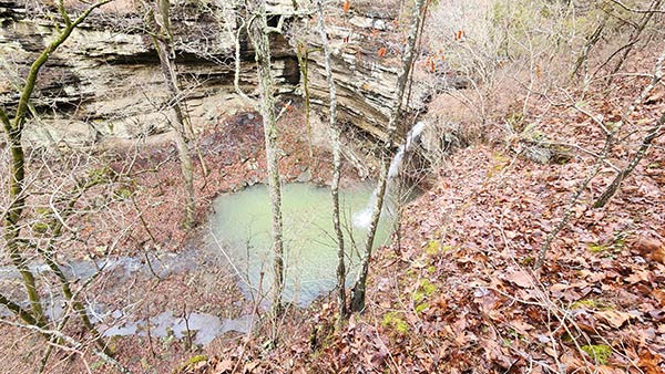
4 – Bluffline Break to Bottom of Falls: 35.53200, -92.81210
5 – Bottom of Lizard Log Falls: 35.53281, -92.81143
6 – Leave Trail #23 for Bluffline Break: 35.53133, -92.81200
7 – Trail #23 Fork: 35.53595, -92.80813
Gez’s GPS Track: Click Here
(Copy/Paste Coordinates into GPS or Google Maps search bar)
Directions
From Hector, head north on Hwy 27 to Dare Creek. Immediately after crossing Dare Creek, turn right on White Oak Mountain Rd (Nfm 1301/Co Rd 1). Continue for about 12 miles and turn right onto Wilderness Trail (Co Rd 2). At about 2.6 miles, you’ll see a pull-off into a clearing on the right side of the road that’s big enough to park and camp. Pull in there. There are other routes to reach this area. If coming from the south or east, use the map below to find the best route.
Once parked, walk towards the back of the parking area, and look for the ATV trail. The trail starts there. Follow the ATV trail until it intersects with a trail that looks like a water drainage. Turn left there and you’ll start seeing yellow blazes in the trees. This is the main trail, Brock Creek Trail #23. There are multiple ways to approach this hike. Be sure to save the GPS tracks and waypoints above, and watch the video below for visuals.
What to Expect
Hiking to Lizard Log Falls can be a bit tricky if you are not familiar with Trail #23 and don’t have a GPS track to follow. But once you are familiar with those things, it’s actually pretty simple. There are two ways to approach Lizard Log Falls from the parking area described above. The Trail #23 approach and the creekside hike approach. It can also be reached from the Austin Trailhead, or by bushwhacking up from Brock Creek. But the two I’ll describe below are the fastest and easiest. I will reference the numbered waypoints listed above in describing both routes. Both approaches I would give a difficulty rating of moderate to difficult. That is due to one small section that is physically challenging. And both can be a challenge to navigate if you’re not prepared.
One safety note I’d like to mention is that the Brock Creek Trail system consists of multi-use trails. This means they are open to dirt bikes, ATV’s, and horses. And you’re likely to see any or all of those while on a hike. I’ve seen all three on different occasions. And they are pet friendly. So if you take your dog hiking, always be prepared to leash your pup. This is not just for dogs that might freak out and run away at the sight of those things. It’s also for the safety of horseback riders. Some horses can get spooked by dogs that run up to them barking. This can create a dangerous situation for the rider. Same goes for dirt bike riders trying to dodge an aggressive dog. Please play nice.


Trail #23 Approach
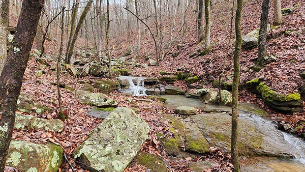
The first approach to hiking to Lizard Log Falls is by taking Brock Creek Trail #23 as far as you can. This is about a 5 mile hike, round trip. When you turn left off the ATV trail at point #1 above, follow it all the way down to the creek. It will be the only creek you see (point #2 above). At this point, you have a decision: hike the creek all the way down or stay on the trail. If you choose to stay on the trail, cross the creek and head up the hill. You’ll quickly reach a fork in the trail, marked by pink tree ribbons to the right (point #7 above). Stay left, following the yellow blazes until you reach point #6. That is where you take a right turn, leaving the trail, and head downhill.
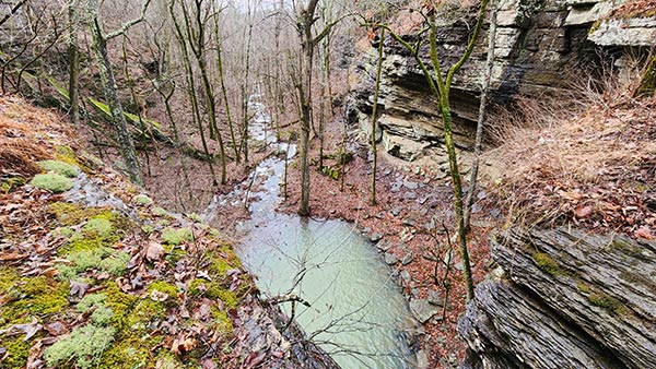
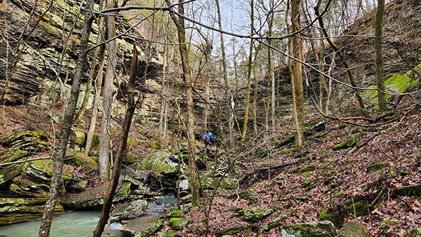
Up until this point, the hike will be easy. Here is where it gets a little more difficult. As you head down the hill towards the bluffline, navigate to point #4 above. This is the bluffline break. There are probably other breaks you can take to get to the bottom of the bluffs. But this is the one we used if you want to save some time from searching. Carefully ease your way down these rocks. From there, it’s a downhill bushwhack to the creek at the bottom of the canyon. Once you reach the creek, take a second to admire the awesome sight of this canyon. Then head up the creek to the falls. It’s an out-and-back trail, so do all that in reverse to get back.
Creekside Approach
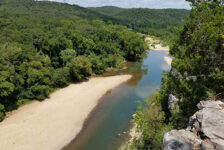
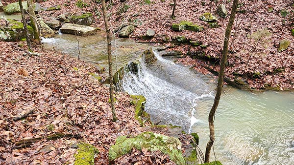
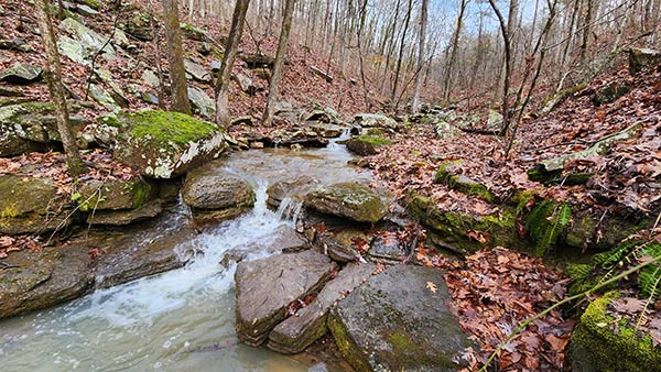
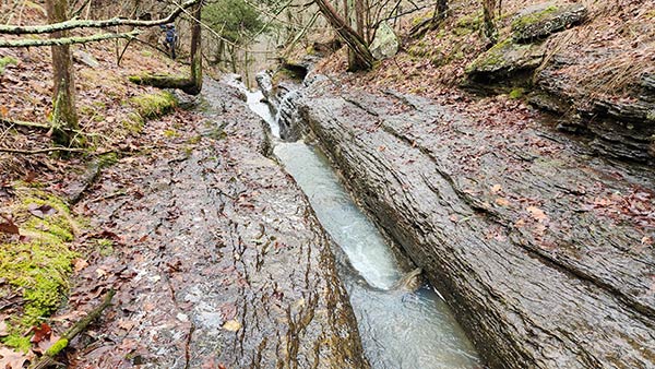
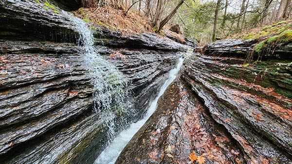
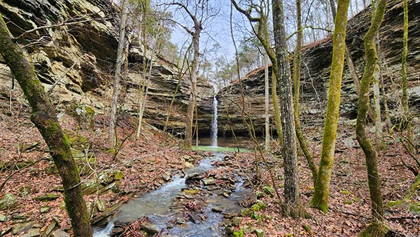
The second approach, which I recommend, is the creekside hike approach. It is shorter and more direct, but also an easy bushwhack down the creek. Starting off the same way on Trail #23, go to point #2 where the trail crosses the creek. Turn right and head down the creek. During the Winter, it’s a fairly clean bushwhack. You have to rock-hop here and there. You might criss-cross the creek a couple of times. But stay close to it, finding the best path you can. Keep at it until you reach the top of the falls where you’ll be treated to a magnificent slot creek.(Point #3 above). More on that later.
From the top of the falls, head up the hill on the left side of the creek to the top of the ridge. Follow the top of the bluffs until you reach the bluffline break (point#4 above). This is the same break you would use if you took the Trail #23 approach. From here, it’s the same instructions as the second paragraph of the Trail Approach description. Except I’ll add that coming up out of this canyon is challenging. Especially climbing up the bluffline break. For this reason, I rate the hike on the high end of moderate. For some, it may be difficult. It definitely requires a high level of mobility. From the top, you can return by going back up the creek the way you came in. Or you can hit Trail #23 just up the hill at point #6.
Lizard Log Falls
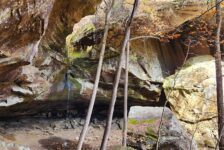
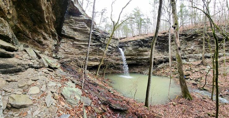
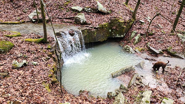
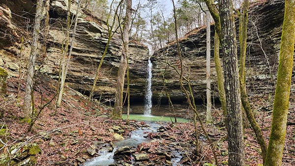
Lizard Log Falls is a beautiful 41-ft waterfall that drops straight down over a grotto into an emerald pool. It is surrounded by a huge canyon with giant vertical bluff walls rising much higher than the waterfall itself. All sides around the bottom of the falls are easily accessible. This makes walking all way around the grotto and behind the waterfall easy. It also makes Lizard Log a very photogenic waterfall. If we didn’t have another hike planned that afternoon, I could have strung a hammock and stayed here all day! There are some other waterfalls further down the creek from Lizard Log. But we completely forgot to go see them on the way out. I’ll have to make a return trip for those!
Lizard Log reminds me a little bit of Brushy Grotto Falls. Both have a slot creek at the top that has carved its way through the bluffs, creating a V-shaped notch at the top. In fact, that’s one of my favorite things about both waterfalls. These are two of the coolest slot creeks that I’ve seen. And it’s the reason I recommend doing the creekside approach when hiking to Lizard Log Falls. (And Brushy Grotto, for that matter). All of these things are featured in the video below, as well as all waypoints listed at the top.
Plan Your Trip
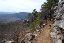
The Brock Creek/Lost Corner area is fairly remote. Plan on driving 10+ miles on dirt roads to get to most of the waterfall hikes in this area. These are pretty good dirt roads though. Four Wheel Drive is not necessary. Also don’t plan on having cell service. You might catch a weak signal here and there, but not likely. That means save all maps, waypoints, and GPS tracks before going. And I recommend using a GPS for all hikes in this area. The main trails here are clear and pretty well-marked. But most waterfall hikes here involve getting off the main trail. And many of them will be over some pretty rugged terrain. I wouldn’t do any of these hikes in anything less than sturdy hiking boots. No tennis shoes or sandals. Also, I recommend using a trekking pole because you’ll be going up and down steep rocky hills, and rock-hopping through creeks.
Since it does take a while to get out there, I recommend planning multiple hikes in the area and making a day of it. To see all the waterfalls in the area, check out the Waterfalls in Arkansas map. Click on each one to find links with information. Also, click here to see all the hikes in the Lost Corner that we have on the blog so far. Because most hikes in this area require some bushwhacking, I don’t hike the area too late into Spring. Once it’s fully green, the vegetation can get pretty thick. So if you go in late Spring, use plenty of bug spray. Most hikes in this area are pretty far from anything. So take food and water with you. Just be sure to pack out what you pack in and leave no trace. Take only pictures and leave only your footprints. Enjoy the hike!