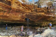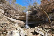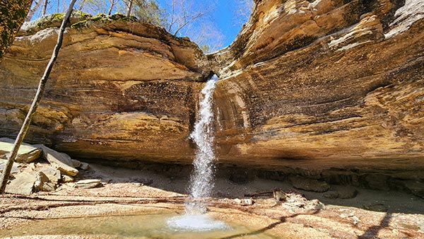
Tea Kettle Falls is one of the more well-known and unique waterfalls in Arkansas. The base of the waterfall is a massive grotto style bluff that is quite an impressive sight on it’s own. The creek flowing over the top of the bluff has carved a hole in the rock at the top of it. Much like Glory Hole Falls, the water drops through this hole before ever making it to the edge of the bluff. But where the hole at Glory Hole falls drops straight down through the bluff, Tea Kettle is different. Instead of the hole coming out the bottom, it re-routes horizontally, shooting the water out the side of the bluff. This rock formation resembles the spout of a kettle, which is how Tea Kettle Falls gets its name. I’ve wanted to do the Tea Kettle Falls hike for quite a while, and finally got the opportunity this Spring.
Tea Kettle Falls is very dependent on recent rainfall in the area in order for it to be flowing strong. And from where I live in Central Arkansas, it’s a longer drive to reach than most other waterfalls in the Ozarks. It is located in the Madison County WMA, about 20 miles south of Eureka Springs. On a recent visit to Northwest Arkansas, I had a Saturday to kill, right after two days of heavy rainfall. What luck! So my brother and I made our way out to Madison County to check the Tea Kettle Falls hike off our list.
Quick Glance
(For the hike WE did. Other approaches to this hike may differ)
Distance: Approximately 2.7 miles out and back
Difficulty: Moderate
Road to Tea Kette Coordinates (turn off Hwy 23): 36.25896, -93.74565
Parking Coordinates: 36.267602, -93.732826
Trailhead Coordinates: 36.27032, -93.73067
Warm Springs Falls #1: 36.26535, -93.72125
Warm Springs Falls #2: 36.26514, -93.71949
Warm Springs Falls #3: 36.26496, -93.71734
Warm Springs Falls #4: 36.26531, -93.71747
Tea Kettle Falls: 36.26641, -93.71490
Warm Springs Falls #5: 36.26574, -93.71849
Warm Springs Falls #6: 36.26750, -93.72145
Reynolds Hollow Falls: 36.26754, -93.72169
(Copy/Paste Coordinates into GPS or Google Maps search bar)
GPS Track: Click Here
Directions
The road to Tea Kettle Falls (CR 410) is located on Hwy 23, just 13 miles south of Eureka Springs, and 12 miles north of the Hwy 412 intersection at Huntsville. See exact coordinates for this road listed above. From Hwy 23, head east on this road for 1.1 miles to the parking area (coordinates listed above).
From the parking area, the road forks, with both forks blocked from vehicle traffic. The fork to the right has a metal gate that will likely be closed. This is NOT the one to take, although I suspect it might lead to an adjacent creek and eventually the same hiking area. But I can’t confirm that. The fork to the LEFT is blocked with a berm and concrete barriers. This IS the road to walk down that leads to the trailhead (coordinates listed above). From the trailhead coordinates, cross the empty field, veering to the right towards the back corner, near the creek. There you will find the beginning of the trail that follows Warm Springs Creek.
What to Expect
The Hike
There are multiple approaches to the Tea Kettle Falls hike. We followed the GPS track from the late Rick Henry’s blog, which follows along Warm Springs Creek.(The GPS track I have linked above is Rick’s track.) It veers off trail in places to see the multiple Warm Springs Falls and Reynolds Hollow Falls. Our hike was 2.7 miles round-trip. It is mostly level hiking all along the creek without much elevation change. However, there is major elevation change between the parking area and the trailhead. For the most part, it follows an unmarked volunteer trail that gets difficult to see in some places. In fact, we lost the trail a few times and did some bushwhacking in some parts. Due to the uphill climb out and the bits of bushwhacking, I would rate this hike as Moderate. Aside from those things, it’s pretty easy. There is also at least one wet creek crossing, which I’ll explain further below.
From the trailhead, follow the trail until it dead ends at a dirt road next to a small creek. Turn left on the road and follow it until it runs into Warm Springs Creek. At that point, turn right, cross the small creek that empties into Warm Springs Creek. Follow the faint trail that runs along Warm Springs Creek. This will take you right past Warm Springs Falls 1-4, on the south side of Warm Springs Creek.
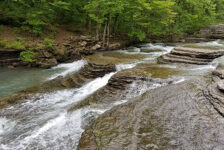
Warm Springs Falls
It is in this section of the hike that we lost the trail. In fact, we lost the trail a few times between Warm Springs Falls 1-4. We weren’t too concerned since we remained close to the GPS track I had saved. The trail runs up the side of the hill to the base of the short bluffs. Just past these short bluffs is Warm Springs Falls #1. At random spots in this area, the trail disappears. We just bushwhacked through these spots, staying close to our GPS track. If you don’t use a GPS, just keep following the direction of the creek. As long as the creek is in sight, you won’t get lost. At one point, we dropped down into the dry part of the creek bed. We found the trail again right around the spot it runs into Warm Springs Falls 3 and 4.
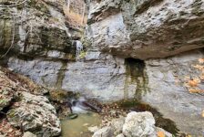
Warm Springs Falls 1 and 2 are nothing special. But 3 and 4 are definitely worth a stop. #3 is a nice 10-ft fall that drops off a small bluff. It then runs off down the hill into #4, which starts off as a small drop, then continues into a long cascade. Both are less than 100 yards off Warm Springs Creek and very easy to reach. After Warm Springs Falls #4, the trail continues in the dry part of the creek bed a few hundred yards down to Tea Kettle Hollow.


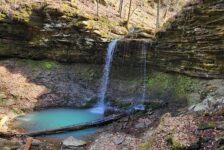
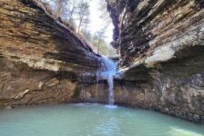
Tea Kettle Falls
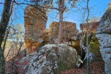
A hundred yards or so before reaching Tea Kettle Hollow, you’ll see why it’s best to follow the trail on the south side of Warm Springs Creek. It’s because the trail on the north side is cut off by a beautiful, but massive bluff along that side of the creek. You would have to go into the creek to go around it, or go over the bluffs. I’m not sure of the hiking conditions up there, but it looked like it would be a significant bushwhack. Not far past this bluff is the hollow where you’ll find Tea Kettle Falls. There’s just one thing in the way – the crystal clear waters of Warm Springs Creek! Time to change shoes and wade the creek. But keep those river shoes on because you’ll need to cross back again when you leave Tea Kettle. All of this is featured in the video below.
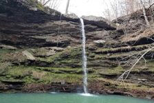
We could see Tea Kettle Falls flowing strong all the way from the creek. I suppose that view might change when the trees have leaves in them. Anyway, follow the sound of crashing water, or find the small creek running out from Tea Kettle and follow that. It’s less than 100 yards to falls. At 46 feet high, Tea Kettle Falls is a really impressive sight. The exposed bluffs surrounding it are even higher, and rise straight up out of the forest floor. Add in the unique tea kettle spout rock feature, and it’s easy to see why this is a favorite among Arkansas waterfall hikers. I could have hung a hammock and stayed here all day. I really didn’t want to leave.
Reynolds Hollow Falls
After Tea Kettle, go back across the creek and head back upstream again until you get past the big bluffs on the right.(The same bluffs I described earlier). Once past the bluffs, cross the creek again back to the same side as Tea Kettle (the north side). We crossed when we saw a trail on that side, which quickly comes upon Warm Springs Falls #5.(Coordinates listed above). After that, continue along the trail until Warm Springs Creek makes a hard right turn. At that point, you have a choice. Splash up the creek to Reynolds Hollow, or follow the gravel road up to the top of the bluff line. The route following the top of the bluffs turns into a bushwhack. But keeping the creek in sight, it will lead to the top of Reynolds Hollow Falls and Warm Springs Falls #6.
Getting from the top of Reynolds Hollow Falls down to the bottom is very easy. It is not a very tall waterfall – maybe 8 or 10 feet high. It is not surrounded by a grotto or any cool rock formations. And yet, there is something really cool about Reynolds Hollow Falls. It looks like the kind of place you might expect to see a Hobbit or something. Warm Springs #6 empties into the same spot, and it’s a really quiet and peaceful place. Once you finally drag yourself away from there, cross back over Warm Springs Creek. We got lucky and found a downed tree to walk across. Then bushwhack up the hill until you hit the same trail that we first started the hike on. Follow that back to the trailhead.
Plan Your Trip
The Tea Kettle Falls hike is one that definitely requires good planning in order to see it flowing strong. It is best seen within a day or so of substantial rainfall in the area. (They got 2 to 3 inches of rain over the previous two days prior to our hike.) You can check recent rainfall here. Because the trail disappears at times and there are many things to see, I highly recommend using a GPS for this hike. Download Rick Henry’s GPS track that I have linked above. At a minimum, save all the waypoints I have listed above. Cell service here is hit and miss, so download all that before you go. There will be at least 2 wet creek crossings. And since they are close together, I recommend taking some creek shoes you don’t mind hiking short distance in.
The Tea Kettle Falls hike is a dog-friendly one. There are no public restrooms in the area. Even though AllTrails says the hike can be done in 45 minutes, give yourself more time than that to really see everything. (We took almost 3 hours.) Take a hammock, or take some lunch and enjoy the area. Just be sure to pack out what you pack in and leave no trace. There are other waterfalls closeby if you want to add another hike to your day. To find other waterfalls in the area, like Eagles Nest and Road 299 Falls, check out the Waterfalls in Arkansas map. This is a great hiking spot to add to any trip to Eureka Springs or the Northwest Arkansas area. If mountain biking or any other activity gets rained out, give this hike a look!