I spent most of my adult life thinking the Cossatot River was so far away from my home in Central Arkansas. I also spent most of that time thinking that Cossatot River State Park was only a destination for whitewater paddlers. It turns out that neither of those things are true, as I found out in 2021. In my first visit to the park, I went to Cossatot Falls to watch the kayakers take on the Class IV whitewater. And while I didn’t see any paddlers hit the “Skull Crusher” that day, I did find a pretty great hiking area. I didn’t give myself enough time that day to explore all the trails there. But I saw enough to know I had to make a return trip to do the Harris Creek Trail hike.
The Harris Creek Trail at Cossatot River State Park is one of the four main hiking trails in the park. Two of those trails are very short. And one of them is a bit long for most people to complete in a day. But at 3.5 miles, the Harris Creek Trail is a nice way to spend a few hours in the park and see some fantastic scenery.
Quick Glance
Distance: 3.5-mile loop
Difficulty: Moderate
Harris Creek Trailhead Coordinates: 34.296623, -94.160553
Cossatot Falls Parking Coordinates: 34.321050, -94.227099
Visitor Center: 34.294007, -94.177177
(Copy/Paste Coordinates into GPS or Google Maps search bar)
Directions
Cossatot River State Park is tucked away deep in the Ouachita Mountains, south of Mena. Traveling on Hwy 278 between Umpire and Wickes, look for the Cossatot River State Park sign on the east side of the park. Pull into the parking lot next to the sign. This is the trailhead for the Harris Creek Trail. See Google Map below.
What to Expect
On my second trip to Cossatot River State Park, I explored the park a little more. After a stop at the visitor center, I checked out the trailheads just down the hill from there by the river. And yet again, I feel like I need to return and hike the 12-mile River Corridor Trail. That one might have to be a camping weekend at the park though. On this visit, my goal was to hike the Harris Creek Trail and see the view from Goats Bluff. And I wanted leave enough time for a return trip to Cossatot Falls and hopefully video some paddlers. Although I did make it to Cossatot Falls that day, I struck out yet again on seeing anyone paddling it. Oh well, let’s get into the Harris Creek Trail hike.
The Hike
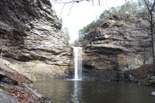
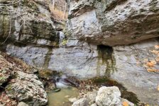
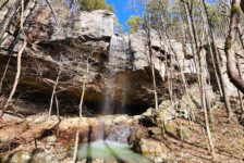
The Harris Creek Trail hike is a 3.5 mile loop on the east side of the Cossatot River. It is mostly an easy hike with a few mildly moderate spots. Follow the trail from the trailhead, and you immediately come to the first overlook for a nice view of Baker Creek. Continuing on the trail a few hundred feet, there is a short trail leading to a creek-level spot on Baker Creek. The main trail continues on through the forest toward Harris Creek. It is a clean and clear trail that is easy to follow. There are some intersections along the way, so follow the yellow blazes in the trees. A little over a mile into it, you’ll reach the first nice view of Harris Creek. There is also a path here leading to a creekside spot in a bend on Harris Creek. This is the only creek-level access of Harris that I saw.
A little over halfway into the hike, you’ll reach the Harris Creek Vista. This is a really nice view of Harris Creek and a good spot for a break. After that, the hiking gets a little tougher. The trail winds it’s way through the forest and up the next ridge to a less impressive vista. It continues to gain elevation on its way toward the Goat Bluff Overlook. After that, the trail starts to descend as it completes its loop toward the trailhead. Along the way, you’ll find the Harris Creek Cutoff which leads to the visitor center. Continue on the Harris Creek Trail to go back to the trailhead. Without rushing through, I completed this hike in 2 hours.


Goats Bluff Overlook
The Goats Bluff Overlook is the highlight of the Harris Creek Trail hike. There is a sign for it that you can’t miss when hiking along the trail. Coming off the main trail, you’ll creep down the ridge past the treeline to a bluff outcropping. From there you’re greeted with a magnificent view of the Cossatot River and surrounding Ouachita Mountains. Just guessing, I’d say this bluff rises over 100 feet above the Cossatot River. And it’s straight down, so don’t get too close to the edge here. But definitely stop to enjoy this jaw-dropping view. It is the only view of the Cossatot on this hike. Although the other vistas are really nice, this is the one that makes the hike worth it. Check out my video below where all the features of this hike are covered.
Plan Your Trip
I think Spring would be the best time to do the Harris Creek Trail hike, when all the creeks have water. But with the vista views, Fall could be a good time too. It’s not one I would do in the middle of Summer when the creeks and rivers are low. I think the views are better with water. Allow yourself 2-4 hours to do the hike depending on your physical condition and how much you like to stop. The park website describes parts of this hike as “steep and rugged”. There are some semi-steep switchbacks. But I wouldn’t describe it as rugged. It’s a pretty smooth trail for the whole hike. The State Park is in a fairly remote and isolated area. So cell service is sparse. The trail is dog-friendly, and there are some great hammock opportunities on this hike.
I recommend getting an early start if you want to explore the park and hike more than one trail. Or if you’re coming from far away, consider spending a weekend at the State Park. Camping is available at Cossatot River State Park and other nearby campgrounds. Click here to see all the camping options and other local accommodations. There aren’t many towns close by. The closest is the small town of Wickes to the west, and there is Dierks to the southeast. So it’s a good idea to arrive with all the food and supplies you need. Limited food and drinks are available at the Visitor Center. Restrooms are also at the Visitor Center and in the park campgrounds. Be prepared to pack out any trash you might have and leave no trace. If you’re looking for scenic adventures in the Ouachitas, give Cossatot River State Park a try.