To the west of Little Rock lies the Maumelle Pinnacles chain of mountain peaks. These peaks somewhat mark the eastern gateway to the Ouachita Mountains. The Maumelle Pinnacles consist of three peaks: Pinnacle Mountain, Rattlesnake Ridge, and Blue Mountain. Pinnacle Mountain has been one of Arkansas’ most visited state parks for decades. And since opening in 2018, Rattlesnake Ridge has become a popular outdoors spot for folks seeking to avoid the Pinnacle crowds. Both of those locations offer excellent hiking and mountain bike trails. And in June of 2023, the third and final peak in the chain was opened to the public. Thanks to the Nature Conservancy and Arkansas Natural Heritage Commission, we now have hiking and mountain biking at Blue Mountain Natural Area.
Directions
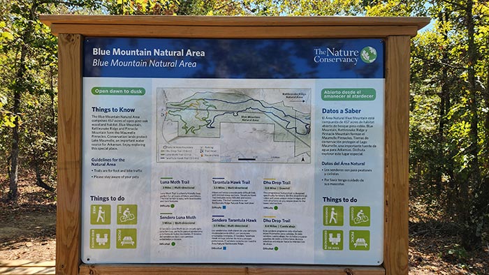
On Hwy 10 west of Little Rock, from the intersection of Hwy 10 and Chenal Parkway, drive west on Hwy 10 for five miles. Just past Harper Construction, after the road makes a big right turn, look for the gravel parking area on the right with a gate. If you reach Lake Maumelle, you’ve gone too far. See map below.
What to Expect
Blue Mountain Natural Area is a 459-acre Natural Conservation Area protected by the Nature Conservancy. And just like Rattlesnake Ridge, this has several implications for hiking and mountain biking at Blue Mountain. First off, it will not be crowded because access is limited. If the parking lot is full, you have to come back later. Next, they try to keep the area as natural as possible. So the trails are not marked the same as you might see in other mountain bike parks. There are a few signs along the way, but no tree markings. And finally, to protect the trails the park may be closed during wet conditions. Like it or not, this is extremely helpful for keeping the trails in good shape.
Hiking
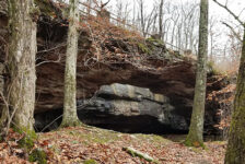
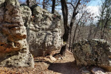
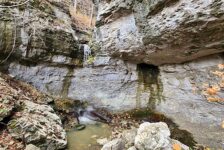
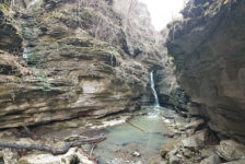
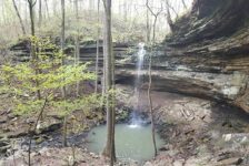
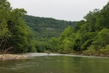
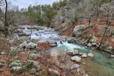
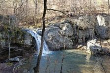
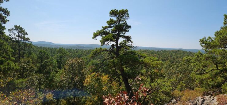
The trails at Blue Mountain were specifically designed and built for mountain biking. However, hiking and trail running is allowed here too. These trails are really fun for biking. But hikers should know that this is mostly just a walk through the woods. It is a pretty walk though, along clean, clear, easy-to-navigate trails. Hikers will see a few interesting rock formations and lots of plant life. It was very dry on my visit, but maybe during rainy season, there will be some creeks flowing through it. The best feature for hikers is the great vista view along the Tarantula Hawk Trail. You’ll get a gorgeous view of the Ouachita Mountains to the south, but be prepared to hike approximately 6 miles to see that. This vista is featured in the video below so you can decide if it’s worth the hike. I will make a return visit to see the parts of Luna Moth trail that I missed
Hiking and mountain biking at Blue Mountain is a slightly different experience that what you’ll find at Rattlesnake Ridge or Pinnacle Mountain. Some hikers will be disappointed to know that none of the three trails lead to the top of Blue Mountain. And I did not notice any volunteer side trails off those that looked like they might lead to the top. According to my research, that might be partially due to some rare plant life that is being preserved. It is unclear from everything I’ve read or heard if there will ever be a trail to the top. Any additional info on that is certainly welcome in the comments below. Blue Mountain Nature area is still a beautiful area to hike. But if you’re looking for a view from a tall peak (that’s not a 6-mile hike), then Pinnacle Mtn or Rattlesnake Ridge is your best bet.


Mountain Biking
One thing that stood out to me about mountain biking at Blue Mountain is that it’s a great place for riders of all skill levels. Beginner and intermediate riders will find these trails to be physically and technically friendly. There are plenty of fast and flowy sections that are lots of fun for anyone. And the trails have been masterfully designed to minimize the strain of the uphill climbs. The uphill sections are gradual with no terribly steep climbs. Experienced riders will find plenty of features to challenge and hone their skills. All of these features have alternate tracks for riders that aren’t comfortable taking them on.
There is a major powerline running east and west through this area. This creates a clearing in the woods that all the trails cross at least once. All those crossings look similar, so don’t be alarmed if you feel like you’re going in circles. There are just over 7 miles of MTB trails here, designed and built by professional trail builders. You’ll find jumps, rock features, berms, bridges, wooden paths and balance features. Everything you need to work on your MTB skills is here. You’ll see a lot of these in my pics above and video below. Here is a list of all the trails at Blue Mountain, with descriptions.
Blue Mountain Trails
- Luna Moth Trail – Green (Easy to Intermediate) – 3.1 mi. – This 3.1-mile loop trail is easy to intermediate in difficulty. It winds through the forest with sections of fast and flowy single track, and random skill features. You have to ride/hike at least part of this loop to reach the other two trails. For biking, I recommend riding it in a clockwise direction.
- Tarantula Hawk Trail – Blue (Intermediate) – 3.5 mi. This 3.5-mile trail is intermediate in difficulty. It connects the Luna Moth Trail to the Rattlesnake Ridge trail system. The Tarantula Hawk Trail has some technical features, rocky sections and climbs, but it also offers rewarding views. The main feature is a nice vista view of the mountains to the south that is only accessible via this trail. I also recommend riding this one in a clockwise direction.
- Dhu Drop Trail – Green (Easy) – 0.8 mi. – This 0.8-mile downhill trail is designed specifically for mountain bikers, but it is also open to hikers. It is short but challenging, with steep sections and technical features. To ride this one downhill, take Luna Moth in a clockwise direction (turning left on Luna Moth from the parking lot). At the first big trail intersection, Dhu Drop will veer off to the right.
Go to the Trailforks website for more details on each of the trails open for hiking and mountain biking at Blue Mountain. Their map will show you all the elevation changes along each of the trails, along with status, reports, and other info. This is helpful for deciding which direction you want to ride a particular trail.
Plan Your Trip
When hiking and mountain biking at Blue Mountain, there are two really important things to remember. First, this is a natural conservation area. Leave this area better than you find it by practicing leave no trace principals. Be prepared to pack out any trash you have and do not disrupt the wildlife or ecosystem here. Next, there is limited access to this area. If the parking lot is full, you have to come back later, so have a backup plan. I recommend driving a few miles east to hike or ride at Pinnacle Mountain or Rattlesnake Ridge. Chances are, you can come back later and get in.
Trail map apps are helpful here but not vital. These trails do not appear yet on the MTB Project app. But again, you can find them on the Trailforks website or app. Blue Mountain is pet friendly and cell service here is good if you need it. However, there are no restrooms. But those can be found at nearby Pinnacle Mountain or a few miles away in West Little Rock. Plan on taking at least an hour or two for hiking the shorter trails. Set aside another hour or so if you want to hike the longer Tarantula Hawk Trail. Mountain biking those will be faster. I biked the long loop in about 2.5 hours. But I stopped a lot to catch my breath and take video. Hope you enjoy hiking or mountain biking at Blue Mountain.