The Steel Creek Overlook hike is a popular hiking spot along the Buffalo River Trail near Ponca, AR. The Western Section of the Buffalo River Trail (BRT) winds its way along the Upper Buffalo River for 37 miles from Boxley to Pruitt. It offers stunning views of the river, as well as access to a variety of other natural attractions, including waterfalls, caves, and bluffs. Along the way are six different trail heads to access different sections of the BRT. Steel Creek to Kyles Landing is one of these sections. It’s an 8.2-mile hike from Steel Creek to Kyle’s Landing. For many people this might be a bit much, especially for a day hike. But the Steel Creek Overlook hike only involves the first 1.5 miles of this section, and is not that difficult. The rewarding views are definitely well worth the effort.
Quick Glance
Distance: Approximately 3 miles out and back
Difficulty:Easy to Moderate
Trailhead Coordinates: 36.040607, -93.341560
Steel Creek Overlook: 36.038085, -93.333049
(Copy/Paste Coordinates into GPS or Google Maps search bar)
Directions
From Boxley Valley, head northeast on Hwy 74 for 1.4 miles. In the middle of the hairpin turn, take a left onto Steel Creek Rd. Take that road all the way down to the bottom into the valley. Where the road forks, park in the triangle, off the side of the road. Walk back up the road you came in on and look for the trail markings on the left. For a visual of this, check out the video further below.


What to Expect
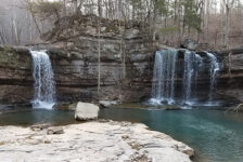
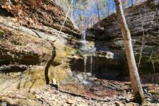
The Steel Creek Overlook hike is approximately 3 miles, out out and back. (If you stop at the overlook.) I recorded a one-way GPS track from the lookout back to the trailhead. That was 1.5 miles. It is truly a tale of two hikes. The hike from the trail head to Steel Creek is very easy. That part of the trail is mostly level, and adorned with beautiful ferns, interesting rock formations, and small waterfalls. It is a very easy hike until you reach Steel Creek. There is one water crossing on this hike (Steel Creek), so be prepared to get your feet wet. I did manage to rock-hop across and keep my feet dry. But that won’t always be the case if the creek is higher.
From Steel Creek to the overlook is very different, and bit more moderate in difficulty. After crossing Steel Creek, the trail winds its way up the mountain to the overlook. Even though there is quite a bit of elevation change, it is not that steep or difficult. The trail was built for backpacking and thru-hiking, so it has enough switchbacks to keep it from being too steep. It will get the blood pumping a bit, but it’s definitely not one of the tougher hikes in the area. This section of the Buffalo River Trail is clean, well-marked, and easy to follow. In the Fall, it can be kind of hard to pick up the trail after it crosses Steel Creek. Parts of it are covered with leaves and difficult to see. But watch the video below to see where that trail picks up.
Extra Features
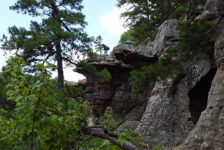
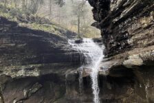
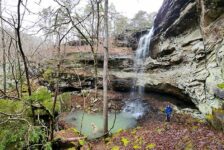
I thought this hike was only going to feature a nice vista lookout over Steele Creek. To my surprise we were treated to several small waterfalls along the way. As you make your way up the winding trail and series of switchbacks to the top, you’ll cross the same creek several times. This creek runs straight down the hill all the way from the top. Along the way, it drops straight off quite a few times, creating a long series of cascades. After the cascades, the trail meanders in between some interesting bluffs and boulders. It was almost a mystical scene where I half-expected to encounter some elves or hobbits.


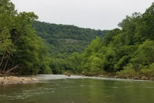
Steel Creek Overlook
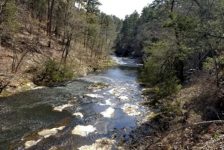
From the overlook, you’ll have views of Steel Creek access area on the Buffalo River with Roark Bluff in the background. The river runs towards the overlook, makes a wide horseshoe bend, and then runs the other direction. While not quite as grande as the view at Big Bluff on the Goat Trail, this is another horseshoe bend in the Buffalo that is impressive to see from high above. Just past the bend are views of Bee Bluff and Cliff Hollow to the north. This is another one of those spots that’s hard to leave. So maybe consider packing a lunch or a hammock and staying a while.
Plan Your Trip
Cell service in this area is hit and miss…mostly miss. So you’ll want to watch the video above before you get there. The trail is well-marked and it’s obvious where to go, so maps and GPS are not really needed for this hike. On most trails around the Buffalo River, dogs are not allowed. But this trail is an exception. Feel free to bring your four-legged hiking buddy on this one! The overlook faces to the west, and I think it would be a great spot to see the sunset. Just be sure to give yourself at least an hour before dark to get back to the trailhead. In total, I recommend planning at least 2 hours to do this hike. There is a bathroom at the Steel Creek access area. Drinks and snacks can be found at the outfitter shops in nearby Ponca.
Plenty of cabins, campgrounds, and places to stay can be found nearby if you want to make a weekend of hiking all the trails in the area. There are a ton of great trails in the area, and you likely won’t cover them all in a weekend. Here is a list of some popular ones to get you started. No matter where you go around the Buffalo National River, be prepared to pack out any trash that you have and leave no trace. Help take care of this treasure by taking only pictures and leaving only footprints. Enjoy the hike!