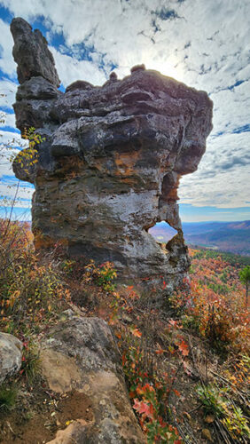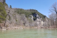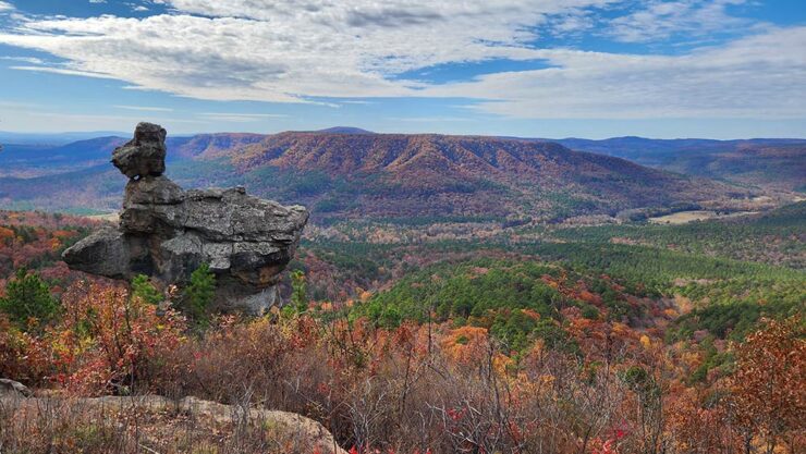
Nestled in the heart of the Ozark Mountains, lies a natural wonder known locally as the Arkansas Sphinx. This sandstone monolith rises 20 feet above its perch near the top of Hess Knob. Its profile bears a resemblance to the iconic sphinx of ancient Egypt. Measuring approximately 20-30 feet tall and just as wide, the Arkansas Sphinx is believed to have been formed over millions of years through erosion. Wind, water, and ice carved away at the softer rock layers, leaving behind the Sphinx-like profile in the sandstone that we see today. Standing tall and proud, the Arkansas Sphinx offers stunning panoramic views of the surrounding countryside. This popular destination for hikers, photographers, and nature enthusiasts stands as a testament to the power of nature’s artistry.
This natural wonder has been on my to-do list for years. After finally giving up on the right time with the right crew, I made a solo trip during peak Fall colors. I combined this hike with another item on my to-do list: a stop at the legendary Hagarville Grocery. After picking up one of their masterpiece sandwiches, I made my way up Hess Knob to admire the spectre of the Arkansas Sphinx. Turns out, my timing on this trip would prove to be perfect after all.
Quick Glance
Distance: Approximately .34 miles out and back
Difficulty: Moderate
Parking Area #1 Coordinates: 35.639211, -93.291492
Trailhead: 35.639135, -93.290926
Arkansas Sphinx: 35.640581, -93.288939
Parking Area #2: 35.65090, -93.29596
Hagarville Grocery: 35.516263, -93.330430
(Copy/Paste Coordinates into GPS or Google Maps search bar)
Directions
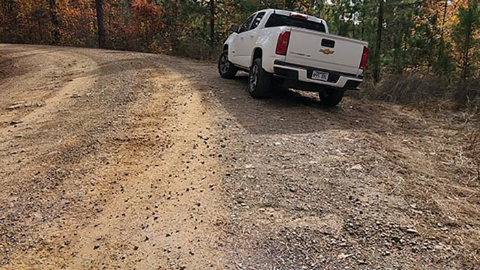
Whatever part of the state you are in, make your way to Hwy 23 between Sand Gap and Hagarville. Coming from the south, at the intersection of Hwy 164 and Hwy 123 in Hagarville, head north on Hwy 123. After 10.6 miles, turn right on Pilot Rock Mountain Rd. Coming from Sand Gap, head east on Hwy 123 from the Hwy 7 intersection. You’ll cross the single lane iron bridge over Big Piney Creek, and pass by Haw Creek Campground. At 16.6 miles from Sand Gap, turn left on Pilot Rock Mountain Rd. Once on Pilot Rock Mountain Rd, go 0.6 miles. The road will widen in the middle of a big curve. This is the parking spot. It’s not much and it’s easy to miss. Use the coordinates posted above. From there, walk about 40-50 yards further up the road to the trail. Be looking on the left side for a faint volunteer trail. It may be marked with stacked rocks or orange paint on a pine tree. (I say “may” because it keeps changing. It used to be marked with a white “S” on a tree). Again, GPS is your friend here. Check out the video below for a visual on the parking and trailhead.
What to Expect
Two Routes
It is important to know that there are two different routes that can be taken to reach the Arkansas Sphinx. If you read something else that doesn’t match this description, that’s why. I chose to take the route from Parking Area #1 because it’s shorter and more direct. It also might be more physically challenging, and I was up for it that day. I was also on a mission to see several things that day, and route #1 is faster.
I have not hiked the route from Parking Area #2 yet. But according to the late Rick Henry, in his blog he wrote that the route from Parking Area # 2 was 1.17 miles each way. He noted that both routes are steep. But route 2 – even though it has twice as much elevation gain (638 feet) – much of it is spread over a longer distance. (So maybe not as steep.)
Route One Hike
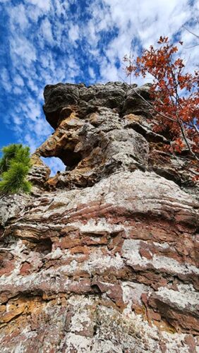
Accessing the Arkansas Sphinx from Parking Area #1 is a short but challenging hike. The trail is only 0.17 miles each way, but has an elevation gain of 350 feet. That’s pretty steep! Once you find the trailhead, you should notice the faint trail as it winds its way up the steep hillside. The trail is not marked, but it is fairly clean and very easy to follow. For a volunteer trail, it was much better than I expected. About halfway up, you’ll clear the tree line and start to get some fantastic views of the surrounding countryside. Looking up the trail, the Sphinx will come into view about 2/3 of the way up.
In the late spring and summer months, the trail might be quite grown up with vegetation. So bug spray will be a must. But in the Fall it was fine. Sturdy footwear is also a must for this hike. And trekking poles for the trip back down make it easier on the knees. Although this route to the Sphinx is relatively short, it is quite steep. So I rate it on the difficult end of moderate. If it were this steep AND a long hike, I would rate it as difficult. Luckily it’s short. But hikers should be in good physical condition and prepared for a challenging hike with appropriate footwear and clothing. All that being said, the views from the top are well worth the effort.


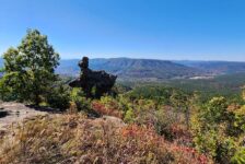
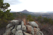
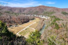
Panoramic Views
The most rewarding part of the hike to the Arkansas Sphinx is the breathtaking view when you get there. The unique rock formation, combined with the stunning views, makes for a perfect photo opportunity. On a clear day, hikers can see for miles in three directions. The rolling hills and valleys of the Ozark Mountains can all be seen from the Sphinx’s perch. It instantly makes my list for one of the best hiking spots in Arkansas to see Fall colors. One of the coolest features of the Arkansas Sphinx is the “window” in the pedestal of the rock formation. It’s a hole that has been eroded all the way through the rock. The background scenery viewed through this window makes for some interesting photos.
There is an abundance of great vantage points for photos just up the hill from the Sphinx. It’s easy to see why visitors take so many pictures here. While I did go a little bit uphill, I discovered later that I should have gone a little further. A few hundred feet further up Hess Knob is an impressive vista with an incredible view. This vista is a waypoint along the hike from Parking Area #2. So now I definitely have to go back sometime and hike route #2.
Plan Your Trip
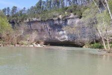
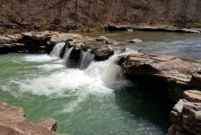
The hike to the Arkansas Sphinx from Parking Area #1 can be done in less than one hour. (Although I recommend taking longer to enjoy the scenery.) So if you’re up for it, there are plenty more great hikes nearby along Hwy 123. Short hikes like Pam’s Grotto and Pack Rat Falls , or non-waterfall hikes like Buzzards Roost would be good. And there are still TONS of waterfall hikes on the west side of Hwy 123, that I have not written about yet. But you can find these on the Waterfalls in Arkansas Map. Again, you’ll definitely want sturdy footwear for this one. And I highly recommend a trekking pole for the trip down. Dogs are welcome on this trail, but it might be a tough one for them.
Cell service is very spotty in this area. While driving, I couldn’t get a signal anywhere within 10 miles of the parking area. But I got a pretty good signal while sitting up above the Sphinx. Food and drinks can be found at Hagarville Grocery (see coordinates above). Their sandwiches are epic (see video below) and the banana milkshake is a great post-hike treat. On the other end of Hwy 123 is the Sand Gap General Store in Sand Gap. Wendell and crew at Sand Gap also make some tasty sandwiches. But Sand Gap General Store is closed on Sundays. So if you’re hiking on Sunday and not near Hagarville Grocery, better pack some food and drinks. Be prepared to pack out any trash you might have on your hike and leave no trace. The Arkansas Sphinx is a reminder of the power and beauty of nature. Its geological uniqueness and gorgeous views make it a must-visit destination for anyone exploring the Ozark Mountains.