The Ozark Mountains, renowned for their rolling hills, deep valleys, and hidden waterfalls, offer a haven for outdoor enthusiasts. Winding through this scenic landscape is the Ozark Highlands Trail (OHT), a designated National Recreation Trail, and a gem of Ozarks. Starting at Lake Fort Smith, this long distance trail winds through the heart of the Ozark National Forest for over 200 miles. This scenic route is known for its diverse terrain, from gentle valleys and meandering streams to challenging climbs and breathtaking vistas. And while it may be a thru-hiker’s dream, the OHT is divided into sections that offer numerous day hiking options. One of those options is the hike to Hobo Falls on the OHT.
I’ve had the hike to Hobo Falls on my to-do list for several years. And long before I knew of Hobo Falls, I’ve wanted to visit Cedar Creek Pool on the OHT. I had been saving this hike in my back pocket for a time when friends requested to join me for a hike. Because I KNEW it was going to be good. And indeed it was! So when my buddies Neil and Eric asked to go hiking, this option was a no-brainer. It’s close to some nearby old favorites we could hike afterward. And I also knew they would appreciate a stop at Hagarville Grocery on the way. So we got our fill of H.G. breakfast burritos, filled our packs with H.G. sandwiches and headed north into the Ozark hills.
Quick Glance
Distance: Approximately 3 mile out and back
Difficulty: Easy to Moderate
Parking Coordinates: 35.68913, -93.31722
Unnamed Falls 1: 35.68802, -93.32023
Unnamed Falls 2: 35.68697, -93.32197
Cedar Creek Pool: 35.682829, -93.330916
Cross Cedar Creek to Hobo: 35.68023, -93.33299
Hobo Falls East: 35.68095, -93.33405
Hobo Falls West: 35.68079, -93.33507
Hagarville Grocery: 35.516263, -93.330430
Hankins Country Store (Pelsor): 35.721263, -93.095938
(Copy/Paste Coordinates into GPS or Google Maps search bar)
Gez Rogers’ GPS Track: Click Here
Directions
Whatever part of the state you are in, make your way to Hwy 23 between Sand Gap and Hagarville. Coming from the south, at the intersection of Hwy 164 and Hwy 123 in Hagarville, head north on Hwy 123. At 11.1 miles, turn left on County Rd 5741/Forest Service Rd 1003. Coming from Sand Gap, head east on Hwy 123 from the Hwy 7 intersection. You’ll cross the single lane iron bridge over Big Piney Creek, and pass by Haw Creek Campground. At 16.1 miles from Sand Gap, turn left on County Rd 5741/Forest Service Rd 1003. Once on County Rd 5741/Forest Service Rd 1003, go 4.7 miles and look for the parking area on the left. The trailhead for the Ozark Highlands Trail is right next to the parking area.
What to Expect
The hike
The hike to Hobo Falls is 3 miles round-trip out and back on the OHT. The OHT is an excellent trail that is well marked and easy to follow. It is designed for thru-hikers and hikers with heavy overnight packs. So it is not technically difficult(at least not this section). This particular hike starts at the top of a hill and descends down into a deep valley. So the first half of the hike is very easy. The hike back out of the valley is a bit more challenging. It is not terribly steep, but it gradually goes uphill pretty much the whole way for 1.5 miles. Overall I would rate it on the easy side of moderate.
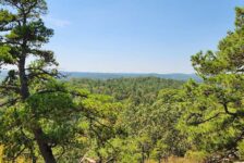
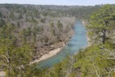
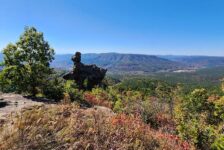
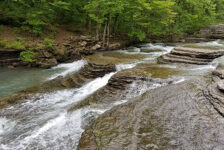
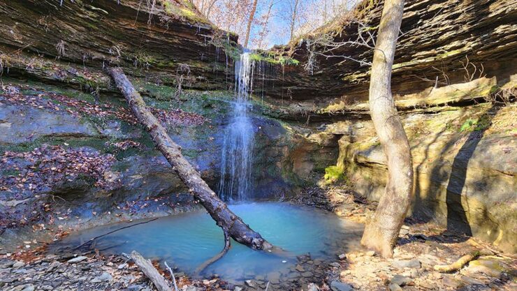
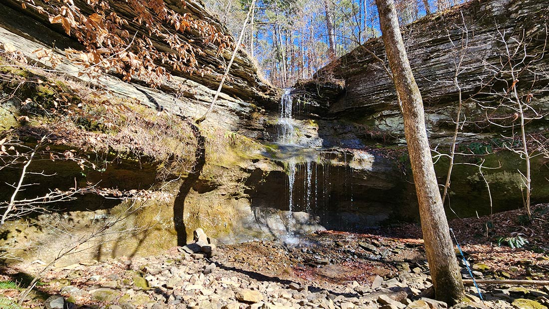
There’s plenty to see along the OHT as you descend into the valley. In the first 3/4 of a mile, you’ll find 3 different unnamed waterfalls right off the trail. They were all just a trickle the day we were there. And if you don’t go in Winter or Early Spring, they’re likely to be dry. But the trail crosses over the tops of each one, so you can’t miss them. In between those are several great views of the valley and surrounding hills. Those views probably disappear when leaves are on the trees. That’s just one of the reasons I enjoy Winter hiking. A welcoming view of Cedar Creek signifies that you’ve reached the bottom of the valley. From there, the hike goes from good to great.
Cedar Creek Pool
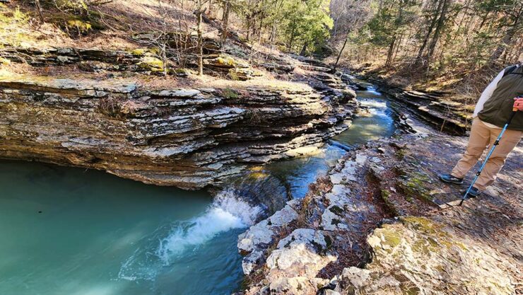
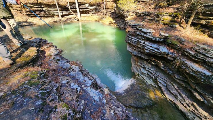
One of my favorite features of the hike to Hobo Falls on the OHT is Cedar Creek Pool. As the trail reaches the bottom of the valley, it runs parallel with Cedar Creek. Within the first 30 yards or so, you’ll notice the creek starts to form a slot channel in the rocks. That gradually forms sort of a waterslide that empties into an emerald pool that’s almost entirely encompassed by short, grotto-style bluffs. On the far end of the pool, the creek continues on downstream. I didn’t see a good way to get down to creekside on the other end of the pool. Unless I missed it, I think the only way is to follow the trail downstream past the bluffline and hike back up the creek. At first glance, it looks like a great spot to take dip in late Spring. But climbing out of that pool looks a bit problematic.
Hobo Falls
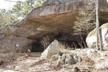
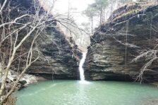
After the pool, the OHT continues to follow along Cedar Creek. Less than a quarter-mile past Cedar Creek Pool, the trail crosses over Cedar Creek. Unless Cedar Creek is really high, it is possible rock-hop across it and keep the feet dry. But it’s a good idea to bring creek shoes after heavy rain in the area. After crossing the creek, you’ll need to break off from the OHT and follow along the creek bed at the bottom of the bluffs on the right. This creek bed snakes its way into a winding box canyon. About 100 yards in, there’s a hollow on the right that forms a nice sized grotto. Here you’ll find Hobo Falls East. It is a 23-ft double-drop waterfall over a shallow grotto. The really neat thing about this one is that the water falls into a small pool, and then seems to disappear underground without draining off into the creek.
Coming back out of the hollow for Hobo East, continue on along the creek bed and around the bend to the right. About another 100 yards further, the canyon dead-ends and you’ll find Hobo Falls West. Only slightly taller at 27 feet, Hobo West is a little bit different. Where the East falls go over a grotto that you can walk behind the falls, the West falls do not. Hobo West drops over the edge, crashing down on the bluffs before hitting the pool below. But the moss and algae on the rocks makes this one the more colorful of the two.


Although we saved our lunch for after the hike, the banks of Cedar Creek would be great spot for a lunch break. On each side of the creek you’ll find some fairly elaborate campsites that make an overnight hike there pretty inviting. Or maybe just a short rest before that uphill hike back out! Be sure to catch the video below where we walk you through all the different stops on the hike to Hobo Falls.
Plan Your Trip
It took us right around 2 hours to make the round trip hike to Hobo Falls on the OHT. So while you’re in the area, you may want to plan to hit one of the many other great hikes along Hwy 123. Short hikes like Pam’s Grotto and Pack Rat Falls , or non-waterfall hikes like Arkansas Sphinx would be good. And there are still TONS of waterfall hikes on the west side of Hwy 123, that I have not written about yet. But you can find these on the Waterfalls in Arkansas Map. Again, you’ll definitely want sturdy footwear for this one. And I highly recommend a trekking pole for the trip down the hill and crossing the creek.
The OHT is a dog-friendly trail. Cell service is very weak in this area. So download any maps, GPS tracks, and waypoints you need before going. You can find my friend Gez Rogers’ GPS track for this hike in the Quick Glance section above. Or just watch the video above and you’ll be fine. Food and drinks can be found at Hagarville Grocery (see coordinates above). Their sandwiches are epic and the banana milkshake is a great post-hike treat. On the other end of Hwy 123 is the Sand Gap General Store in Sand Gap. Wendell and crew at Sand Gap also make some tasty sandwiches. But Sand Gap General Store is closed on Sundays. So if you’re hiking on Sunday and not near Hagarville Grocery, better pack some food and drinks. There are no restrooms near the trail, but there are plenty of trees! Be prepared to pack out any trash you might have on your hike and leave no trace. Enjoy the hike!