In 2020, I made my first visit to Hemmed-in Hollow Falls. Admittedly, I took the short, easy route by making the quick hike from the Buffalo River while on a float trip. I knew about the popular hike to Hemmed in Hollow from the Compton Trailhead, and had heard it was pretty difficult. So after seeing the impressive sight of the falls crashing down into the hollow, I figured I could check this one off my list. (Seeing the falls is the whole point, right?). But after years of hiking other waterfalls, I felt like I needed this challenging hike on the blog. So I decided to return to Hemmed-in Hollow to do the hike from the top.
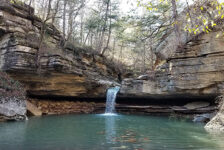
Hemmed in Hollow Falls, located on the Buffalo National River, is 209 feet tall. That makes it the tallest waterfall in Arkansas. In fact, it’s the tallest waterfall between the Rocky Mountains and Appalachians, according the National Park Service. If you’re feeling adventurous, you can also see second tallest waterfall in Arkansas – Diamond Falls – just around the bend from Hemmed-in Hollow Falls. More on that further below. The Compton Trailhead starts in the hills above the top of the falls and the trail ends at the bottom of the falls. You can also reach Hemmed-in Hollow from the Centerpoint Trail, but it’s a longer hike. Here I’ll be focusing the route from the Compton Trailhead.
Quick Glance
Distance: Approximately 5 miles out and back
Difficulty: Difficult
Parking Coordinates: 36.081228, -93.303201
Hemmed-in Hollow Falls: 36.07204, -93.30748
Diamond Falls: 36.07167, -93.30944
JB Country Store: 36.091900, -93.306827
(Copy/Paste Coordinates into GPS or Google Maps search bar)
Directions
Wherever you’re located in the state, map yourself to JB Country Store in Compton (or directly to the point marked on the map below). Right across the road from JB Country Store is County Rd 121. Take that 0.2 miles and turn right on County Rd 19. Follow that for 0.8 miles, and turn right on Hemmed-in Hollow Road. The parking area and trailhead will be immediately on the left. There are two trailheads that start from the parking area. Choose the one on the left.
TIP: If the parking area is full, drive on past Hemmed-in Hollow Rd and keep going. Further down County Rd 19 is the parking area for Hideout Hollow. It’s shorter, but also a great hike.
What to Expect
The Hike
From the parking lot, there are two trailheads. The one on the right is the Sneeds Creek trail. That will take you away from Hemmed-in Hollow and connect with the Centerpoint Trail. Take the trail on the left to go to Hemmed-in Hollow. The hike to Hemmed-in Hollow from the Compton trailhead is about 5 miles round-trip on an out-and-back trail. Although it’s only 2.5 miles each way, it is 1180 vertical feet down to the bottom. So the hike back out is a challenging one. The trail does flatten out in a few short parts. Other parts are rather steep, and some of the rocks are muddy and slick. I found myself going quite slow in some parts on the way down. Although I rate the hike to Hemmed-in Hollow as difficult due to the climb out, it was not as difficult as I expected. Maybe that’s due to some tough hikes I had done prior to that to prepare me. And maybe others will disagree. But some reviews I had read before had me expecting worse.
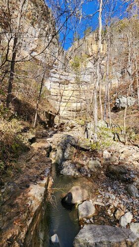
There are other trails in the area that intersect here and there. But the trail is well-marked and easy to follow. Read the signs at each trail fork and follow the signs to the falls. Along the way, there are side trails that break off with opportunities to find an old abandoned cabin and several primitive camp sites. After the trail makes a sharp left turn descending to the bottom of the gorge, it crosses a creek. After heavy rainfall, this might look more like a cascading waterfall. And it might be wet crossing. But I was able to rock hop across and keep my feet dry that day.
Hemmed-in Hollow Falls
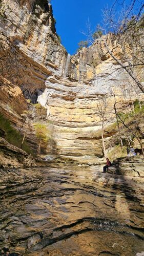
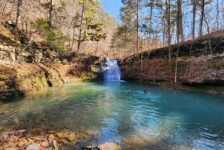
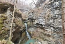
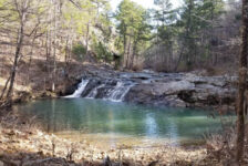
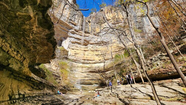
A hundred yards or so past the creek, the trail forks again. A right turn will lead you to the Buffalo River banks. Take a left turn to continue on to Hemmed-in Hollow. Almost immediately you’ll run into a nice waterfall on the right. If there is enough water flowing, it will be a twin waterfall on the right and a cascading waterfall on the left. After crossing over the top of those and continuing down the trail, you’ll almost immediately see the next waterfall. It’s a 15-ish foot grotto waterfall on the right. Just as you pass by that, the sight of Hemmed-in Hollow looms in the distance. In fact, it kind of hits you right in the face. As the trail turns into a creek bed leading into the hollow, a little rock-hopping is required. Once you clear the creek, the sight of the massive bluffs with the falls dropping 200 feet down is quite the “wowwwwww” moment.
As the bluffs of Hemmed-in Hollow seem to completely wrap around you, it becomes clear how the place got its name. There is no shortage of amazing vantage points to view the falls. I recommend taking some time to relax here, explore all the space, go behind the falls, find a nice seat and have lunch…all the things. I could easily string up a hammock and stay all day. The hollow really has an enchanting feel to it. I immediately wished I had planned better and started my hike much earlier in the day. And that leads us to…Diamond Falls.


Diamond Falls
Diamond Falls is the second-tallest waterfall in Arkansas. And it’s just around the bend from Hemmed-in Hollow. But there is no trail and from what I understand, it is kind of a sketchy bushwhack. My hike to Hemmed-in Hollow was in November (short days) and I started at noon. So one reason I didn’t do it, was that I wasn’t sure I’d have time to do it and still hike out of there before dark. (Also because I didn’t know how long the hike back would take). The other reason was because I didn’t fully know what to expect with the bushwhack and how safe it was. So I was hesitant to do it alone. But I’m sure I’ll be back sometime when Backflip David and I are floating down the Buffalo.
To get to Diamond Falls, I only know two routes. And they are the routes the late Rick Henry describes in his blog. Facing Hemmed-in Hollow Falls, scramble up the hill on the right side of the falls. There is a thin ledge about 40-50 ft high that wraps around the bluff behind the waterfall. Take that ledge around to the other side of the falls. From there, follow the bluffline around the bend to the next hollow. That’s the traditional route. And according to Rick, it is NOT safe and he does NOT recommend anyone take it. So I listened to him. The other route involves a muddy hillside on the left side of the falls. I was unable to find it, but also ran out of time. But if you want to give it shot, check out Rick Henry’s detailed info HERE.
Plan Your Trip
The hike to Hemmed-in Hollow takes about three to four hours depending on how long you want to hang out or explore. Definitely longer if you want to find Diamond Falls. It took me 3h40m total, including my long stop at the falls. I would say allow yourself a minimum of four hours to fully enjoy the hike. Minimum five hours for slower hikers. Due to the significant effort this hike requires, you’ll want to make sure there is water in falls before you hit the trail. So check that there’s been recent rainfall between Compton and Harrison. If you want to fit one more short hike into your day, I recommend Paige Falls just right down the highway. If spending a few days in the Upper Buffalo area there are plenty more to be found, like Hideout Hollow, Thunder Canyon Falls, Big Bluff/Centerpoint Trail (aka Goat Trail) and many more. You could make a whole weekend of hiking the trails between Ponca and Compton and probably not see them all. There are plenty of cabins in the area for rent to do just that.
The road from the highway to the trailhead is all dirt and gravel. It gets muddy in some parts and a little washed out in others. A four-wheel-drive is not necessary, but not ideal for a low-rider or sports car. As for pets, dogs are not allowed on the trails in the Buffalo River NPS areas. But I saw several on my hike. So take your chances if you wish. But the rangers can write a ticket for it. I don’t agree with the rule, but I also don’t agree with the lazy pet owners that leave their dog poop on trails. So I get it. There is no cell service at the parking area (AT&T), but I did get a spotty signal in one spot halfway down the trail. So if you want to download a map or GPS track, do it before you go. Though it’s really not needed.
There are no restrooms here. The closest one is at JB Trading Store in Compton. They have food, restrooms and lots of awesome hiking and floating gear. As I always say, be prepared to pack out any trash you might have on your hike to Hemmed-In Hollow and leave no trace. Take only pictures and leave only your footprints. If waterfall hikes is your thing, then this scenic hike is an epic one you should add to your list. I hope you enjoy it as much as I did. Be safe out there and happy trails.