On the rare occasion that I get much further west than the town of Ozark, it’s usually because I’m spending the night somewhere in Northwest Arkansas. It’s a little far for a day trip from Central Arkansas (my home), especially during the short Winter days when I do most of my hiking. So any time I travel to Northwest Arkansas, I try to check one of the waterfall hikes west of Ozark off my list. One of those hikes that had been on my list for a long time was the hike to Devils Canyon Falls. When I finally had an opportunity to peel off I-40 for a few hours to do it, this hike instantly made my favorites list. A short list that includes hikes like Thunder Canyon, Richland Creek, Winding Stairs, and Tea Kettle Falls, among others.
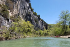
The hike to Devils Canyon Falls is a somewhat popular hike for folks that do a lot of day hiking. But if you’re new to Arkansas or hiking in general, then you may not know about it. This hike is unique in that it covers a diverse landscape with several scenic hiking elements in it. On this adventurous hike, you’ll see several vista points overlooking a deep canyon. You’ll see multiple waterfalls, creeks, and a maze of rock formations. When I say “adventurous”, it’s because one section of the trail involves a climbing rope. But don’t let that scare you. The hike is very much worth doing even if you skip that section. I’ll explain below, so keep reading.
Quick Glance
Distance: Approximately 3.25 miles out and back
Difficulty: Mostly Easy – 1 Difficult part
Parking Area 1 (by highway): 35.62598, -94.03497
Parking Area 2 : 35.62915, -94.03861
Vista #1: 35.63244, -94.03623
Vista #2: 35.63265, -94.03436
Leave ATV Trail: 35.63401, -94.03094
Devils Canyon Jr. Falls: 35.63471, -94.03120
Roped Bluffline Break: 35.63739, -94.03483
Devils Canyon Falls: 35.63750, -94.03485
GPS Track: Click Here
(Copy/Paste Coordinates into GPS or Google Maps search bar)
Directions
From parts of Arkansas south of Devils Canyon, take I-40 to exit 24. Head north up Hwy 215 for 7.8 miles. At that point, look for an unmarked road on the left. You’ll see a mailbox and worn spots where people have parked. If any doubts, use the coordinates above for Parking Area 1. From Northwest Arkansas area, take I-49 to Mountainburg. Take Hickory St to Old Locke Rd/NF-1007. Turn right on Old Fern Rd, which eventually turns into Hwy 215. Going this way, it’s best to just plug in the Parking Area 1 coordinates to your GPS and navigate there. Once you reach Parking Area 1, you have the option to park here or drive up the dirt road. I drove up the road as far as I could to Parking Area 2 above. I have decent ground clearance but no 4WD. This cuts a good half-mile off the hike. Past that, the road does get very rough and muddy, with deep wash-out valleys that will require 4WD.
What to Expect
The hike
I followed the GPX track of my friend Gez Rogers, of Waterfalls in Arkansas and Other Cool Places Facebook Page. That one is loosely based on the route in Tim Ernst’s Arkansas Waterfalls book. If you go strictly off Tim’s info in the book, just know that this hike has changed a bit since he wrote that. Tim wrote that there is no trail for this hike. But since his writing, there certainly is a distinct volunteer trail that has developed as this hike has gained popularity and foot traffic.
The hike to Devils Canyon is around 3.25 miles round-trip on an out-and-back trail. Tim Ernst mentioned a loop route to get back. But from what I saw, I suspect the end of that loop might be a good bit of bushwhacking. The first part of the hike goes along an ATV trail. Along this trail, there are several side trails that break off to bluffs with some amazing vista views. There is a point where you leave the ATV trail to head into the first canyon. This point is easy to miss, but was marked with some stacked rocks. I also have the waypoint coordinates for this spot listed above. From there it is a volunteer trail that is not marked. In the Fall, it might even be hard to pick up some sections of it. But by Spring, it’s been hiked enough that the trail is visible. For the most part, this hike is pretty easy. There is one uphill section coming back that’s a little tiring. The descent down into Devils Canyon is the only part I would consider difficult for some.
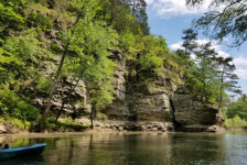
The first section of the volunteer trail leads you around and over some really cool boulders to a point overlooking for the first canyon. At the bottom of that canyon is the first waterfall, Devils Canyon Jr Falls. Continue on the trail as it descends down the hill to the top of Devils Canyon Jr Falls.
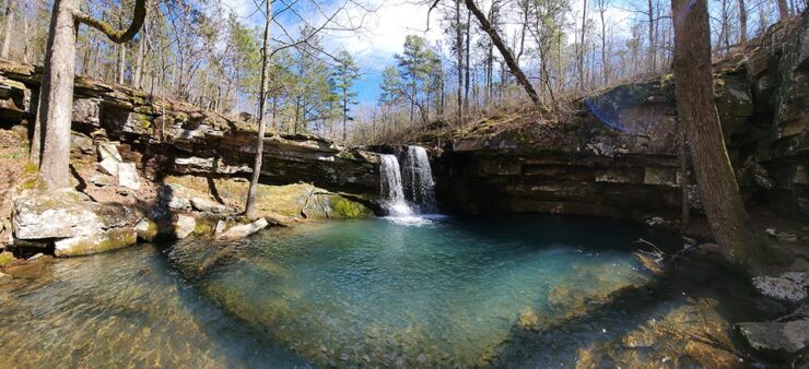
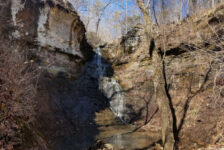
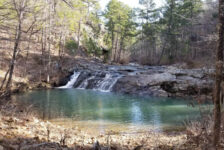
Devils Canyon Jr Falls
Devils Canyon Jr Falls is a little over halfway to Devils Canyon Falls. You’ll definitely know it when you’re there. The trail comes down the hill and goes right over the top of the falls. A creek flows in from the right and empties 15 feet down into a beautiful emerald green pool on the left. Rock hop across the creek to get down the other side of the grotto to the bottom. It’s very enchanted-looking place, worthy of a well-placed hammock. Devils Canyon Jr Falls on its own would be worth the hike. But there’s still so much more to see.
You’ll find more to explore down the creek as it flows away from Devils Canyon Jr. But to continue on to Devils Canyon, go back to the top of Devils Jr and turn left. The trail continues up the hill on the other side and winds through a labyrinth of huge boulders and rock formations. These boulders look impressive from the bottom of Devils Jr Falls. But walking over, around, and through them really shows you how massive these stones are.


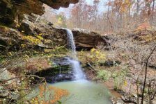
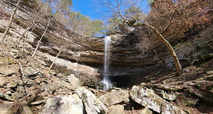
Devils Canyon Falls
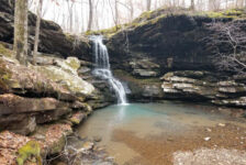
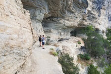
Just past the boulder maze, the trail makes a gradual descent down the hill and around the bend into the next hollow. And this is where the hike to Devils Canyon Falls goes from great to making my favorites list. As you make the final right-hand turn around the bend, it will be fairly obvious that Devils Canyon is on the left below the trail. You’ll know when you reach the bluffline break (waypoint in the Quick Glance section above) by the sight of a red climbing rope. The decent down into the canyon to view the falls is very steep. Steep enough that a climbing rope has been left there to help people safely get down and back up the bluff. But don’t let that scare you out of this hike. It’s not like a rock-climbing situation. The rope is just there to assist and make it safer. Watch the video below to see if that part of the hike is for you or not. For me, it was one of my favorite parts. I suspect that the trail along the top might continue on around to the top of the falls. But I was so jazzed to climb down the rope that I didn’t think to check it out. Sorry!
At the end of the rope, Devils Canyon Falls is in sight. The easiest way to creek level is to go to the right. This will also take you under the grotto, behind the falls, and around to the other side. At 63 ft. tall, Devils Canyon Falls is a fairly tall one. The grotto is gigantic and opens up into a beautiful gorge with so many fantastic vantage points to view the falls. The canyon is flanked on both sides with towering bluffs that reach out into the surrounding forest. During wet season, you might see water falling off the top of the bluffline like a shower. The accent of blooming redbud trees in the Spring adds a nice decoration to this impressive canyon. Pack a lunch because you’ll want to spend some time here before hiking out.
Plan Your Trip
Hiking Time: Approx 2 hrs, minimum
4WD Needed?: No
Cell Service: Little to none (AT&T)
Dogs Allowed: Yes
Map or GPS needed: GPS track recommended
The best time to plan your hike to Devils Canyon Falls is from mid-winter to late spring to ensure there is plenty of water flowing. Although it only takes two hours to complete the hike, that would be rushing it. I would plan on at least 3 hours if you want to take your time to enjoy the hike or really explore the area f you want to make a full day or weekend of hiking, there are other waterfalls in the area that I have not written about yet. But you can find these on the Waterfalls in Arkansas Map
With little to no cell signal here, it’s important to download a map, waypoints, or GPS track before you arrive. Since the trail is unmarked, I do recommend using a GPS track, or at a minimum, download some waypoints to your device. There are no restrooms here. If you don’t want to go in the woods, you’ll need to plan a bathroom break well ahead of arriving. Be sure to bring water. And if you pack lunch or snacks, be prepared to pack out any trash you might have and leave no trace. Take only pictures and leave only your footprints. If you love waterfall hikes, then this scenic hike is an epic one that’s sure to make your favorites list. I hope you enjoy it as much as I did. Be safe out there and happy trails.