
Years ago, I had the opportunity to go trail riding at Mack’s Pines on Hwy 7, north of Dover. And let me tell you, we had an absolute blast doing it. That was years before I had learned the lay of the land when it comes to waterfall hikes. So little did I know that day, that the waterfall we stopped to admire on our ride was actually Stave Mill Falls. And because we entered the trail riding area a good bit south of Mack’s Pines, I didn’t realize how close we were to the Moccasin Gap Recreation Area. Nor did I have any idea that it was only a short hike to Stave Mill Falls and Little Oak Falls.
Fast forward several years and many dozen trips past Moccasin Gap on Hwy 7. This hike made my to-do list, but kept getting passed over for other hikes I wanted to check off my Tim Ernst waterfall book. This one is not in that book, by the way. But it stayed on my list as an easy backup option for when I didn’t have time to plan a hike. And one Sunday afternoon, I did just that. Joining up with my buddy Gez Rogers, we stopped in at Moccasin Gap to revisit Stave Mill Falls by foot.
Quick Glance
Distance: Approximately 3.5 miles out and back
Difficulty: Easy to Moderate
Moccasin Gap Campground: 35.576033, -93.068143
Parking Coordinates: 35.57117, -93.06839
Stave Mill Falls: 35.57128, -93.08397
Little Oak Falls : 35.57326, -93.08297
(Copy/Paste Coordinates into GPS or Google Maps search bar)
Directions
Go to the Moccasin Gap campground on Scenic Hwy 7. Coming from the south, it is 15.5 miles north of Dover. Or coming from the north, it is 13 miles south of the Hwy 16/123 intersection with Hwy 7 at Pelsor. From either direction, look for the signs for Moccasin Gap campground. Once you pull off Hwy 7 at Moccasin Gap, drive down the gravel road past the campground. Approximately a quarter mile past the campground, there is a parking area on the left. Park there, walk back to the gravel road. You’ll see two ATV trails. Take the ATV trail on the left.
What to Expect
The Hike
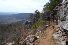
The Moccasin Gap area is a vast network of ATV trails. So there are multiple ways to get to the falls. But most of them involve riding an ATV. For our hike, this is the way we went, and I think it’s probably the best way. Our hike to Stave Mill Falls was approximately 3.5 miles round trip on an out-and-back trail. The trail itself is a clear, wide ATV trail and easy to hike. But I would rate the hike as easy-to-moderate due to a good bit of elevation change. The hike back is almost all uphill. But it’s a gradual uphill and not too steep or rugged.
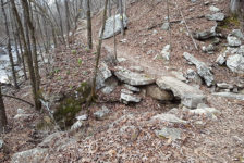
There were four forks in the trail on our hike to Stave Mill Falls. Stay to the left at the first fork, right at the second fork (in the curve), and left at the last two forks. All of these turns are featured in the video further below. But just remember left, right, left, left. Follow the signs to “Stave Mill Falls” or “SM Falls”. Keep in mind, this is an ATV trail riding area first. In some spots they might come through pretty fast. Be respectful of ATV riders, this is their domain. Move aside and let them by.


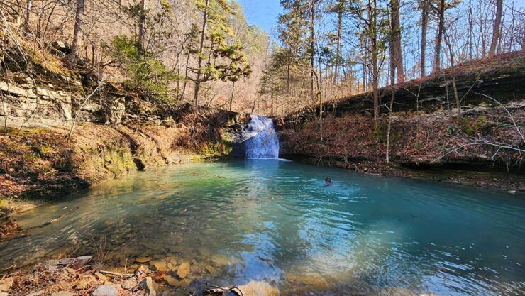
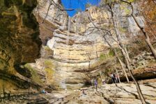
Stave Mill Falls
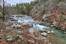
After the fourth and final trail fork, the trail will lead you around a bend, down a hill, and right over the top of Stave Mill Falls. The bedrock creek bed at the top of the falls made it immediately recognizable from my ATV ride years ago. The creek rushes over the top of the bedrock forming a waterslide fall that empties into a big emerald pool. It’s not really a bluff or a grotto. I would say it looks more like a big hole in the ground, except one end of it opens up where the creek runs off. It is pretty though, especially when it has that trademark Ozark emerald green water in it. To get to the bottom, go back along the trail the way you came in. There is a break in the bluffline on that side. See the video further below for details on that.
From here, the hike to Stave Mill Falls now becomes the hike to Little Oak Falls. Backtrack on the trail back up the hill until you see another trail fork off to the left. See the video below.
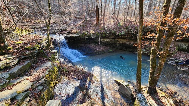
Little Oak Falls
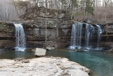
Follow the last trail a short distance until you run into another fork. Again, stay to the left towards the creek. Upon reaching the creek, look down and to the left and there is Little Oak Falls. You have arrived! In my opinion, it is kind of like a smaller version of Stave Mill Falls. A flat creek emptying over the rocks as a waterslide fall that spills into another emerald pool. Surrounded on each side by embankments, Little Oak Falls also resembles a large hole in the ground. From the top of the falls, cross the creek and head to the other side to get down to the bottom. That side is not steep and is very easy to get down.
When the water is high, there are other cascades to explore further down the creek from Little Oak Falls. Just follow the creek down. There wasn’t enough flow for us that day so we didn’t bother. Once it’s time to go, just take the same trail out the way you came. Go up the hill where it connects back with the main trail. And you guessed it – turn left! From there the hike is uphill almost all the way back. But it’s gradual, so take your time and it’s not too strenuous.
Plan Your Trip
Hiking Time: Approx 2 hrs
4WD Needed?: No
Cell Service: Spotty and weak (AT&T)
Dogs Allowed: Yes
Map or GPS needed: No, but it’s helpful
The best time to plan your hike to Stave Mill Falls is from mid-winter to late spring to ensure there is plenty of water flowing. Autumn might be good if there is any rain. If you want to make a full day or weekend of hiking, there are plenty of other waterfalls in the area. Just across Hwy 7 is Cabin Falls and Maidenhair Falls. I have not written about those yet. But you can find these on the Waterfalls in Arkansas Map. Or you can head south to the Longpool Campground area to hike Longpool Falls, Rough Hollow Falls, and others. Or head north towards Pelsor for Native American Falls, or one of many others in the Big Piney Forest.
With little to no cell signal here, it’s important to download a map, waypoints, or GPS track before you arrive. There are no restrooms here aside from a campground pit toilet. If you can’t stomach those and don’t want to go in the woods, better plan a bathroom break before arriving. If you’re like me and love a good obscure roadside eatery, check out Mack’s Pines. It’s just a minute down Hwy 7 and serves breakfast and lunch (great burgers!). For the hike, be sure to bring water. And if you pack lunch or snacks, be prepared to pack out any trash you might have and leave no trace. Take only pictures and leave only your footprints. Be safe out there and happy trails.


Greg Bartz
Hey Scott! Thanks for all the great content! Jenna and I just closed on a cabin property near Shirley overlooking the middle fork of the little red river. We thought it looked like a good paddle and the interwebs brought us to your video on YouTube and an soon after watching it, your website here. I’ll be taking in your experience and following your adventures (and floats and footsteps) as we explore our new back yard. Hope to meet you one day!
-Greg & Jenna
Scott Hallmark
Hi Greg & Jenna! I’m glad you found my site and I hope it’s helpful to you. I appreciate the kind comment. I gotta say, that cabin sounds like a slice of heaven. The Middle Fork Little Red is a fantastic float when the water is up. You should get some good fishing in there too. Thanks for following the blog. If you see me on a river or trail sometime, please say hello!