While Grapevine Shelter might not be as widely recognized as some of Arkansas’ more famous natural landmarks, it is a captivating destination for adventurous hikers and waterfall lovers. Located in the Lost Corner area of the Southern Ozarks, this one is a little bit of a hidden gem. Like many other waterfalls in the Lost Corner area, Grapevine Shelter is not found in Tim Ernst’s waterfall book (second edition). But there are several falls close by that Tim included, such as Blue Hole Cascades and Green Grotto Falls. If you make the drive to see those, you might as well see Grapevine Shelter while you’re there. But only if you’re up for a challenge. Because the hike to Grapevine Shelter is not for everyone. Being mostly a bushwhack through the woods, this one requires some navigation/orienteering skills. And some hiking stamina is helpful for the steep descents and challenging uphill return hike. But this impressive bluff, waterfall, and rock formations, are well worth the effort. And if you have the gas to continue on to Blue Hole Cascade, you won’t regret it.
Quick Glance
Distance: Approx. 5.7 mile loop (our route)
Difficulty: Moderate-to-difficult bushwhack
Parking Coordinates: 35.53773, -92.87905
Unnamed Falls #1 and #2 : 35.53246, -92.88213
Grapevine Shelter : 35.53199, -92.88488
Unnamed Falls #4 : 35.53187, -92.88478
Unnamed Falls #5 : 35.53073, -92.88564
Unnamed Falls #6 : 35.53058, -92.88554
Unnamed Falls #7 : 35.53033, -92.88444
Unnamed Falls #8 : 35.53059, -92.88441
Unnamed Falls #9 : 35.52804, -92.88410
Blue Hole Cascade North: 35.52134, -92.87903
Blue Hole Cascade South: 35.51972, -92.88007
County Line Falls: 35.52408, -92.87037
Green Grotto: 35.52408, -92.87037
Scramble up hill to ATV trail: 35.52453, -92.86951
ATV trail to the road: 35.52790, -92.86844
Green Grotto Parking: 35.534838, -92.864729
(Copy/Paste Coordinates into GPS or Google Maps search bar)
GPS Track: Click Here
Scroll down to “Export”, choose “GPX”, then open the file in your GPS app.
Directions
From Hector, head north on Hwy 27 to Dare Creek. Immediately after crossing Dare Creek, turn right on White Oak Mountain Rd (Nfm 1301/Co Rd 1). Continue for about 1.5 miles and turn left onto Lindsey Mtwy. From there, go .9 miles. You’ll see a clearing on the left big enough for several vehicles. That’s the parking area for Green Grotto Falls. Go another 0.8 miles to the Grapevine Shelter parking area on the left. The exact coordinates of the parking area are listed above. From Central AR, make your way to Jerusalem and head north on Forestry Rd 32/Jerusalem Rd. Follow for 6.7 miles and turn left onto White Oak Mountain Rd (Nfm 1301/Co Rd 1). Continue for 0.1 miles and turn right onto Lindsey Mtwy. Then follow the same directions as above. If coming from the North or East, use the map below to find the best route.
NOTE: When looking at a map, it looks like the shortest route from Hector is to turn right directly onto Lindsey Mtwy off Hwy 27. And it is the shortest. But it requires driving across Hurricane Creek and Illinois Bayou East Fork. If the water is low enough and you have 4WD, it’s doable. Otherwise, I don’t recommend this route.
What to Expect
The Hike
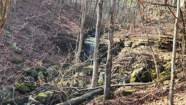
There is not a single, correct, or best way to hike to Grapevine Shelter that I’m aware of. We partially followed the directions from the late Rick Henry’s hiking blog combined with directions from my friend Gez Rogers. Following Gez’s directions, we started off on the jeep road. Then we broke off to the left, bushwhacking down into the canyon to find Rick Henry’s GPS track. At one point, we ended up on top of Grapevine Shelter, with no way to the bottom. After bushwhacking all the way along the top of the Grapevine bluff, we finally found a way down to bottom. That put us right on top of two unnamed waterfalls that we were looking for. These falls are on Rick Henry’s route, so we were finally on track.
If following Rick Henry’s GPS track from the parking area, it’s only about 3/4 of a mile to Grapevine Shelter. However, our clumsy approach found us wandering through the woods for well over a mile before reaching Grapevine Shelter Falls. No matter which way you go, it’s a bushwhack to reach Grapevine Shelter.
From Grapevine Shelter, it’s another bushwhack along the bluffs and down the hill on the way to Blue Hole. Once it levels out along the creek, you’ll hop on another ATV trail all the way to Blue Hole. For the return hike from Blue Hole you have a choice. You can go back the way you came in, which means difficult bushwhack uphill. Or you can bushwhack up the creek to Green Gotto Falls nearby. From there, it’s a short uphill bushwhack to another ATV trail. This trail leads uphill to the parking area for Green Grotto. Then take the road back to the Grapevine parking area. We chose the latter route, which is close to 6 miles round-trip.
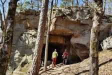
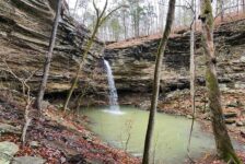
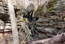
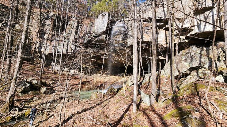
Grapevine Shelter
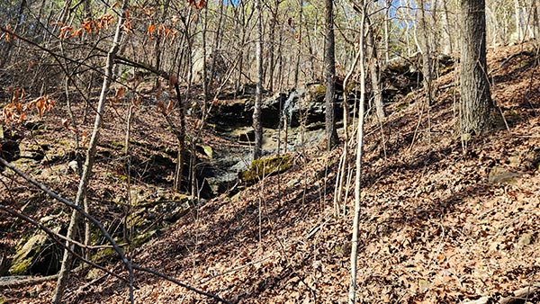
I think the best way to reach Grapevine Shelter is to use the GPS track above to navigate to Unnamed Falls #1 & 2. It’s a moderately difficult bushwhack no matter how you reach that point. From there it’s simple – follow the base of the giant bluff all the way to Grapevine Shelter. Along the way you’ll wind through a labyrinth of huge boulders. And suddenly, you’ll run right into Grapevine Shelter. As long as you stay fairly close to the bluffs, you can’t miss it. All of the turns, waypoints, and landmarks mentioned are featured in the video further below.
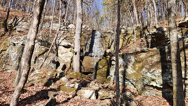
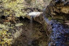
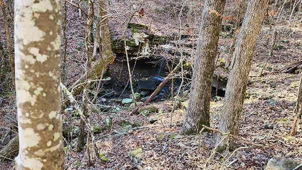
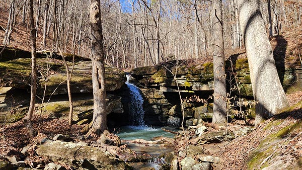
Grapevine Shelter is a massive bluff with a deep grotto cave at the bottom. The waterfall drops off the top of this bluff, plunging roughly 40-50 ft to a pool right in front of the cave. The cave itself is pretty large, as far as grotto caves go. When the water is really flowing in the area, you’ll find more running water in the back of the cave. Another small cave can be found along the drainage down the hill from the main waterfall. At this small cave, you’ll find Unnamed Falls #4.
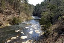
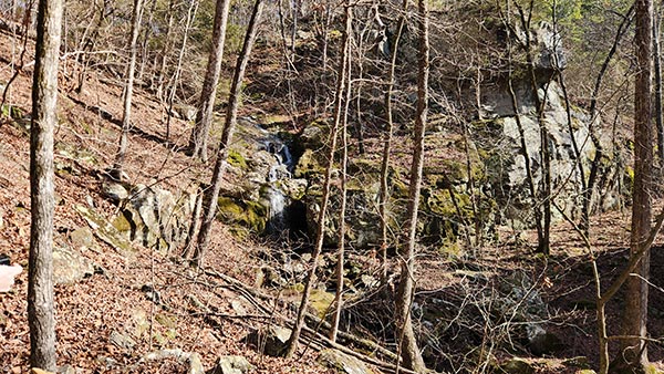
Leaving Grapevine Shelter, we stayed on Rick Henry’s GPS track, headed to Blue Hole Cascades. Facing away from Grapevine, the track turns right and winds down the hill, staying between the bluffs and the drainage. If you stay on the GPS track, you’ll come up on another small creek. As this creek flows down the hill, it creates a series of waterfalls. These are Unnamed Falls 5, 6, and 7. Around the bend from #7 is Unnamed Falls #8 from another small creek. Continue hiking along the creek until it reaches an ATV trail.
Blue Hole Cascades
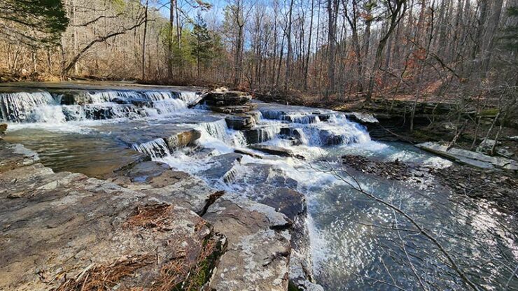
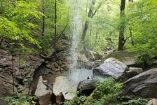
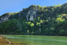
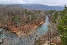
If you make it to the ATV trail, hop on it because it’s the highway to Blue Hole Cascade! With the hike to Grapevine Shelter and slightly beyond being mostly a bushwhack, this clear trail is a welcomed sight. It’s a mostly level hike along this trail that runs fairly close to Hurricane Creek. Blue Hole Cascades consists of two sets of falls – Blue Hole North and Blue Hole South. The ATV trail brings you to the convergence of the two creeks that form these falls. At that point, you’re 3 miles into the hike. Where the trail meets the creek, Blue Hole North is to the left. You’ll want to get your feet wet and cross the creek right there. Because Blue Hole South is across the creek and up the right fork. It’s the more impressive of the two cascades. Yes the water is cold, but you didn’t come this far to wimp out and not see it. So cross the creek!
It’s probably less than 100 yards up the creek to Blue Hole South. And the extra effort is worth it because it’s a beautiful spot. The water flowing over the multiple rock ledges in this wide part of the creek is visually hard to describe. So be sure to catch that part in the video below. Upon leaving Blue Hole South, you’ll notice another ATV trail. Walking up this trail, it cuts the corner and leads straight to Blue Hole North. The North cascade is a little smaller and less majestic than its southern counterpart. But on its own, it is still a really nice cascade. We wanted to stay longer, but daylight was waning. It was time to start our hike back.


Multiple Routes
There are multiple routes to hike to Blue Hole Cascades. The route we took is just one way to do it. But I think it’s easier to get to Blue Hole Cascades by hiking to Green Grotto Falls and on down to County Line Falls. And from County Line Falls, just follow the creek on down to Blue Hole North. We decided this route would be an easier return hike than bushwhacking back uphill through Grapevine Shelter. So from Blue Hole North, we set out bushwhacking up the creek to County Line Falls.
From County Line Falls, we followed an adjacent creek that leads up to Green Grotto Falls. Well before reaching Green Grotto, we scrambled up the hill through the woods to another ATV trail. Having done the Green Grotto hike, I knew this ATV trail was there. It leads all the way to the Green Grotto Parking area on Lindsey Mtwy. Even though this ATV trail is uphill all the way and steep in parts, I felt it would be easier than the way we came in. Upon reaching the parking area, it was a smooth stroll down Lindsey Mtwy to our Grapevine Shelter parking spot. This route added some distance, but probably saved us some time. This hike ended up being almost six miles total. If I were to hike to Blue Hole again, I would take the Green Grotto route.
Plan Your Trip
Hiking Time: Approx 5 hrs for this route
4WD Needed?: No
Cell Service (AT&T): Little to none
Dogs Allowed: Yes
Map or GPS needed:Yes. GPS waypoints/track needed
The best time to plan your hike to Grapevine Shelter or Blue Hole Cascades is from mid-winter to late spring to ensure there is plenty of water flowing. The hiking time for this hike will vary depending on physical condition, hiking skill, and the route you choose to hike back. The route we chose took us 5.5 hours. But there were a lot of stops for lunch, rest, pictures, and navigation. I estimate hiking only to Grapevine Shelter would take half that time or less. Regardless of how long you take, if you’re traveling to this area, you might as well plan on a full day here. You could spend a full weekend in the Lost Corner area and not see everything. Other waterfalls close by include Green Grotto, Brushy Grotto, Ladderbucket, Iris Falls, Lizard Log Falls, and Schoolhouse Falls, among others. There are tons of other waterfalls in the area that I have not written about yet. But you can find these on the Waterfalls in Arkansas Map
With little to no cell signal here, it’s important to download a map, waypoints, or GPS track before you arrive. This hike is mostly a bushwhack along with some sections of unmarked ATV trails. So using a GPS track, or at a minimum, saving some waypoints to your device will be essential. There are no restrooms here. If you don’t want to go in the woods, you’ll need to plan a bathroom break well ahead of arriving. Be sure to bring water. And if you pack lunch or snacks, be prepared to pack out any trash you might have and leave no trace. Take only pictures and leave only your footprints. If you’re seeking an off-the-beaten-path adventure in Arkansas, consider venturing into the Lost Corner area and discovering the wonder of Grapevine Shelter for yourself.