
#moderatehike

Hike to Grapevine Shelter and Blue Hole Cascades
While Grapevine Shelter might not be as widely recognized as some of Arkansas’ more famous natural landmarks, it is a captivating destination for adventurous hikers and waterfall lovers. Located in the Lost Corner area of the Southern Ozarks, this one is a little bit of a hidden gem. Like many other waterfalls in the Lost Corner area, Grapevine Shelter is not found in Tim Ernst’s waterfall book (second edition). But there are several falls close by that Tim included, such as Blue Hole Cascades and Green Grotto Falls. If you make the drive to see those, you might as well see Grapevine Shelter while you’re there. But only if you’re up for a challenge. Because the hike to Grapevine Shelter is not for everyone. Being mostly a bushwhack through the woods, this ...

Hike to Stave Mill Falls and Little Oak Falls
Years ago, I had the opportunity to go trail riding at Mack’s Pines on Hwy 7, north of Dover. And let me tell you, we had an absolute blast doing it. That was years before I had learned the lay of the land when it comes to waterfall hikes. So little did I know that day, that the waterfall we stopped to admire on our ride was actually Stave Mill Falls. And because we entered the trail riding area a good bit south of Mack’s Pines, I didn’t realize how close we were to the Moccasin Gap Recreation Area. Nor did I have any idea that it was only a short hike to Stave Mill Falls and Little Oak Falls. Fast forward several years and many dozen trips past Moccasin Gap on Hwy 7. This hike made my to-do list, but kept getting passed over for other hikes I wanted to check off my Tim E...

Hike to Devils Canyon Falls
On the rare occasion that I get much further west than the town of Ozark, it’s usually because I’m spending the night somewhere in Northwest Arkansas. It’s a little far for a day trip from Central Arkansas (my home), especially during the short Winter days when I do most of my hiking. So any time I travel to Northwest Arkansas, I try to check one of the waterfall hikes west of Ozark off my list. One of those hikes that had been on my list for a long time was the hike to Devils Canyon Falls. When I finally had an opportunity to peel off I-40 for a few hours to do it, this hike instantly made my favorites list. A short list that includes hikes like Thunder Canyon, Richland Creek, Winding Stairs, and Tea Kettle Falls, among others. The hike to Devils Canyon Falls is a somewh...

Hiking the Second Route to the Arkansas Sphinx
Some hikes are worth a re-visit. And a second viewing of that iconic monolith perched near the top of Hess Knob – known as the Arkansas Sphinx – is one such hike. There are two hiking routes you can take to the Sphinx. On my first trip there (read here), I opted for the shorter – but much steeper – route from parking area #1. While preparing for that hike, I read an article from the hiking blog of the late Rick Henry with info on a second route. Mr. Henry described the second route to the Arkansas Sphinx as longer, but less steep and strenuous than route #1. This route also hits the peak of Hess Knob with a magnificent vista view of the Sphinx and it’s scenic backdrop. So in my first Arkansas Sphinx article and video, I promised to come back to try the second ...
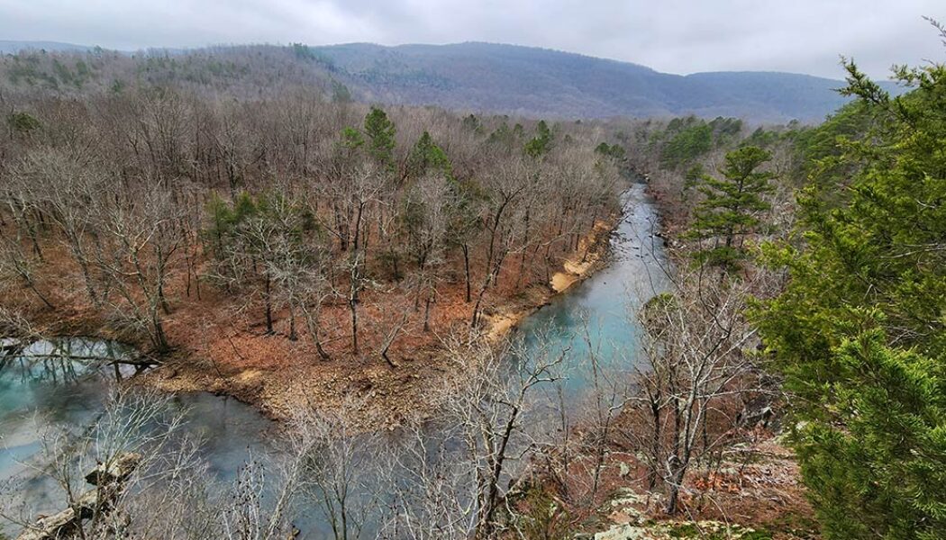

Exploring Bluffton Preserve – A Natural Gem in the Southern Ozarks
Tucked away in a beautiful valley just six miles north of Clinton in the southern Ozarks lies the Bluffton Preserve Nature Area. This is another natural area managed by the Nature Conservancy. Through the help of generous donors, the Nature Conservancy is the same group responsible for bringing us other wonderful recreational areas like Rattlesnake Ridge and Blue Mountain. While exploring Bluffton Preserve, I immediately realized this place is an outdoors treasure chest. There are professionally built trails for mountain biking, hiking, and backpack camping. Four miles of the Archey Fork Little Red River flows right through the area, with an access point for launching canoes and kayaks. This picturesque stream provides swimming holes, fishing, and a beautiful backdrop for hiking and observ...

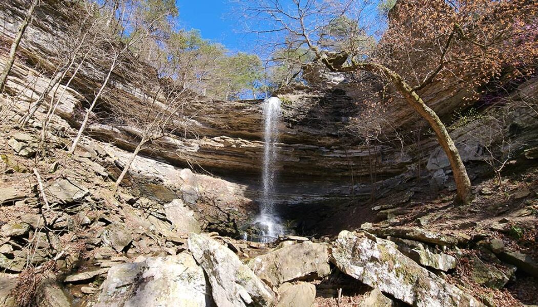
Hike to Hobo Falls on the OHT
The Ozark Mountains, renowned for their rolling hills, deep valleys, and hidden waterfalls, offer a haven for outdoor enthusiasts. Winding through this scenic landscape is the Ozark Highlands Trail (OHT), a designated National Recreation Trail, and a gem of Ozarks. Starting at Lake Fort Smith, this long distance trail winds through the heart of the Ozark National Forest for over 200 miles. This scenic route is known for its diverse terrain, from gentle valleys and meandering streams to challenging climbs and breathtaking vistas. And while it may be a thru-hiker’s dream, the OHT is divided into sections that offer numerous day hiking options. One of those options is the hike to Hobo Falls on the OHT. I’ve had the hike to Hobo Falls on my to-do list for several years. And long be...
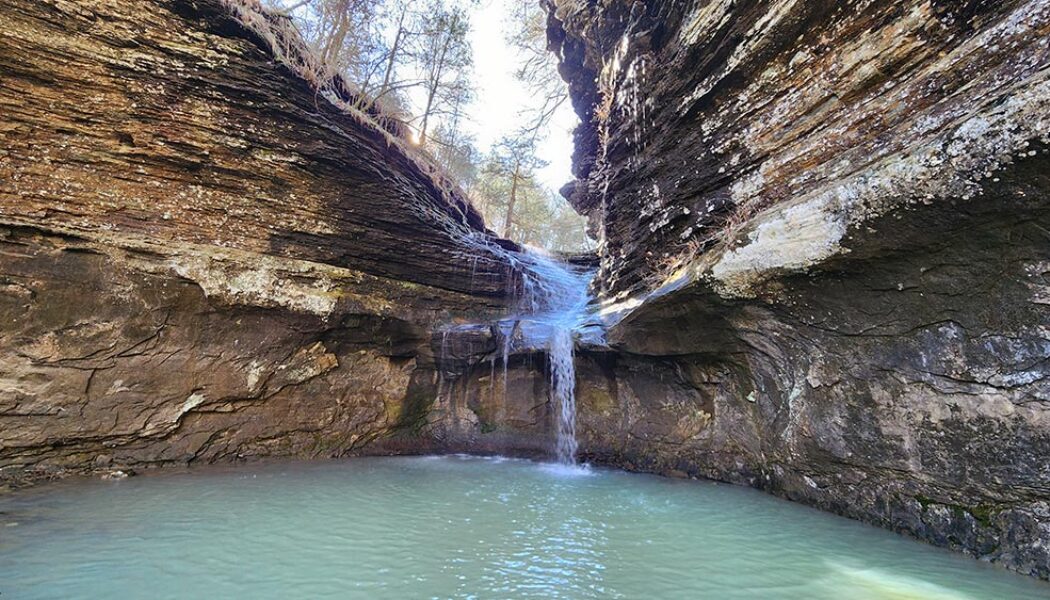

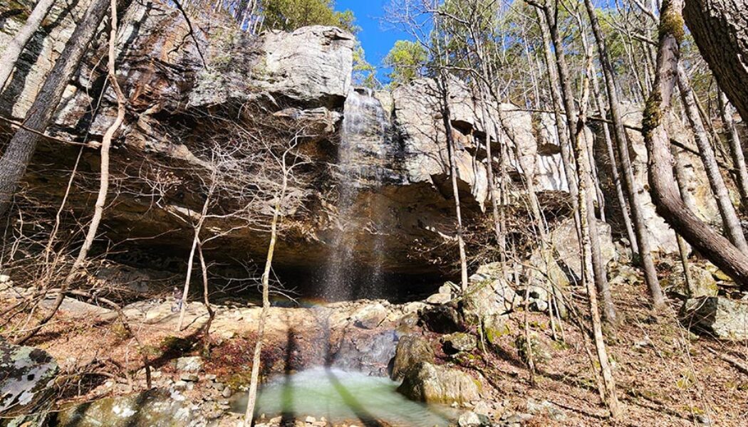
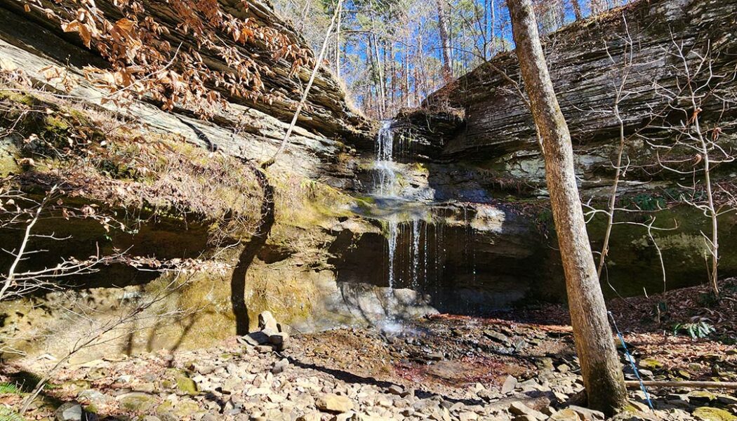
Hike to Ladderbucket Falls and John Mountain Falls
Tucked away in the rolling hills and verdant valleys of the southern Ozarks, lies a tiny mountaintop community aptly named Lost Corner. As it’s name implies, it is an area that many people don’t know much about, if they even know it exists at all. You will not find any stores, shops, restaurants, or many signs of civilization at Lost Corner. But what you will find is a remote wilderness area rich with streams, bluffs, steep ravines, and wildlife. It’s an area I visit several times a year for it’s seemingly endless options for waterfall hikes. My most recent trip would include the hike to Ladderbucket Falls and John Mountain Falls. For this hike, my good buddy David and I would team up once again with Gez Rogers and Super Leeds of Waterfalls in Arkansas. Gez is the c...
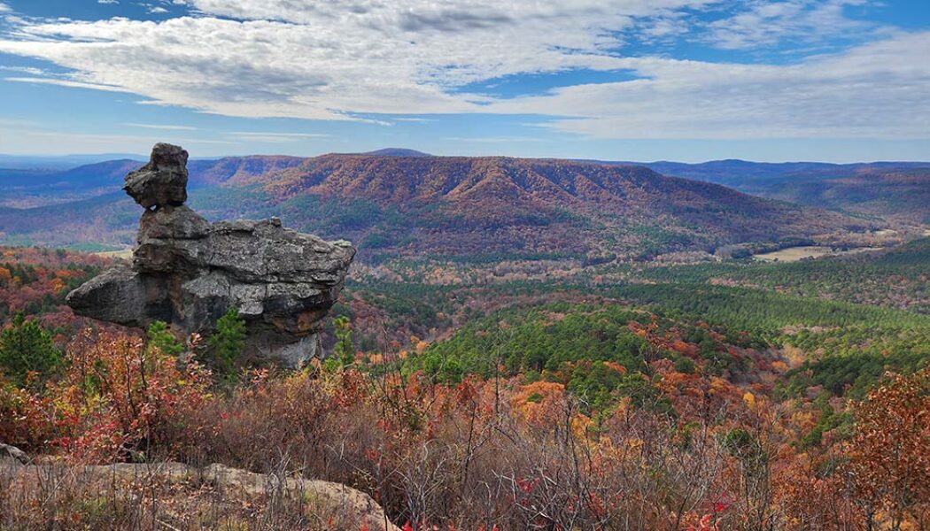

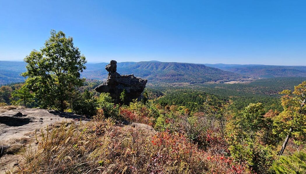
The Arkansas Sphinx: A Natural Wonder in the Ozarks
Nestled in the heart of the Ozark Mountains, lies a natural wonder known locally as the Arkansas Sphinx. This sandstone monolith rises 20 feet above its perch near the top of Hess Knob. Its profile bears a resemblance to the iconic sphinx of ancient Egypt. Measuring approximately 20-30 feet tall and just as wide, the Arkansas Sphinx is believed to have been formed over millions of years through erosion. Wind, water, and ice carved away at the softer rock layers, leaving behind the Sphinx-like profile in the sandstone that we see today. Standing tall and proud, the Arkansas Sphinx offers stunning panoramic views of the surrounding countryside. This popular destination for hikers, photographers, and nature enthusiasts stands as a testament to the power of nature’s artistry. This natura...
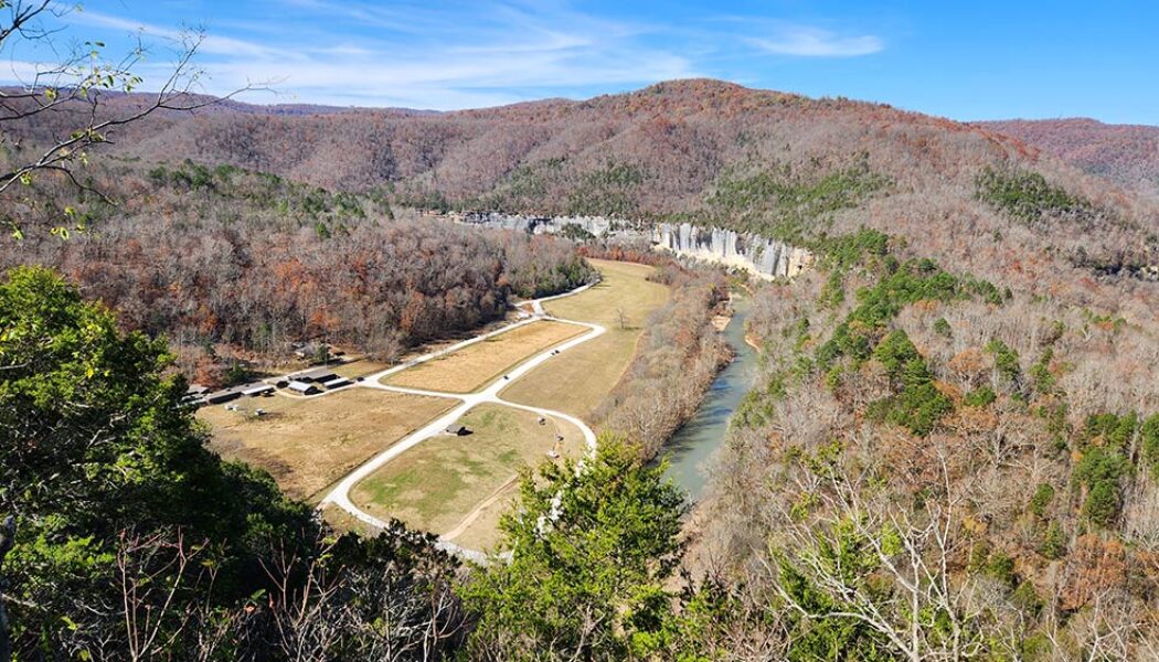

Steel Creek Overlook Hike on the Buffalo River Trail
The Steel Creek Overlook hike is a popular hiking spot along the Buffalo River Trail near Ponca, AR. The Western Section of the Buffalo River Trail (BRT) winds its way along the Upper Buffalo River for 37 miles from Boxley to Pruitt. It offers stunning views of the river, as well as access to a variety of other natural attractions, including waterfalls, caves, and bluffs. Along the way are six different trail heads to access different sections of the BRT. Steel Creek to Kyles Landing is one of these sections. It’s an 8.2-mile hike from Steel Creek to Kyle’s Landing. For many people this might be a bit much, especially for a day hike. But the Steel Creek Overlook hike only involves the first 1.5 miles of this section, and is not that difficult. The rewarding views are definitely...

Hiking and Mountain Biking at Blue Mountain Natural Area
To the west of Little Rock lies the Maumelle Pinnacles chain of mountain peaks. These peaks somewhat mark the eastern gateway to the Ouachita Mountains. The Maumelle Pinnacles consist of three peaks: Pinnacle Mountain, Rattlesnake Ridge, and Blue Mountain. Pinnacle Mountain has been one of Arkansas’ most visited state parks for decades. And since opening in 2018, Rattlesnake Ridge has become a popular outdoors spot for folks seeking to avoid the Pinnacle crowds. Both of those locations offer excellent hiking and mountain bike trails. And in June of 2023, the third and final peak in the chain was opened to the public. Thanks to the Nature Conservancy and Arkansas Natural Heritage Commission, we now have hiking and mountain biking at Blue Mountain Natural Area. Directions On Hwy 10 wes...

Harris Creek Trail Hike at the Cossatot River
I spent most of my adult life thinking the Cossatot River was so far away from my home in Central Arkansas. I also spent most of that time thinking that Cossatot River State Park was only a destination for whitewater paddlers. It turns out that neither of those things are true, as I found out in 2021. In my first visit to the park, I went to Cossatot Falls to watch the kayakers take on the Class IV whitewater. And while I didn’t see any paddlers hit the “Skull Crusher” that day, I did find a pretty great hiking area. I didn’t give myself enough time that day to explore all the trails there. But I saw enough to know I had to make a return trip to do the Harris Creek Trail hike. The Harris Creek Trail at Cossatot River State Park is one of the four main hiking trails ...
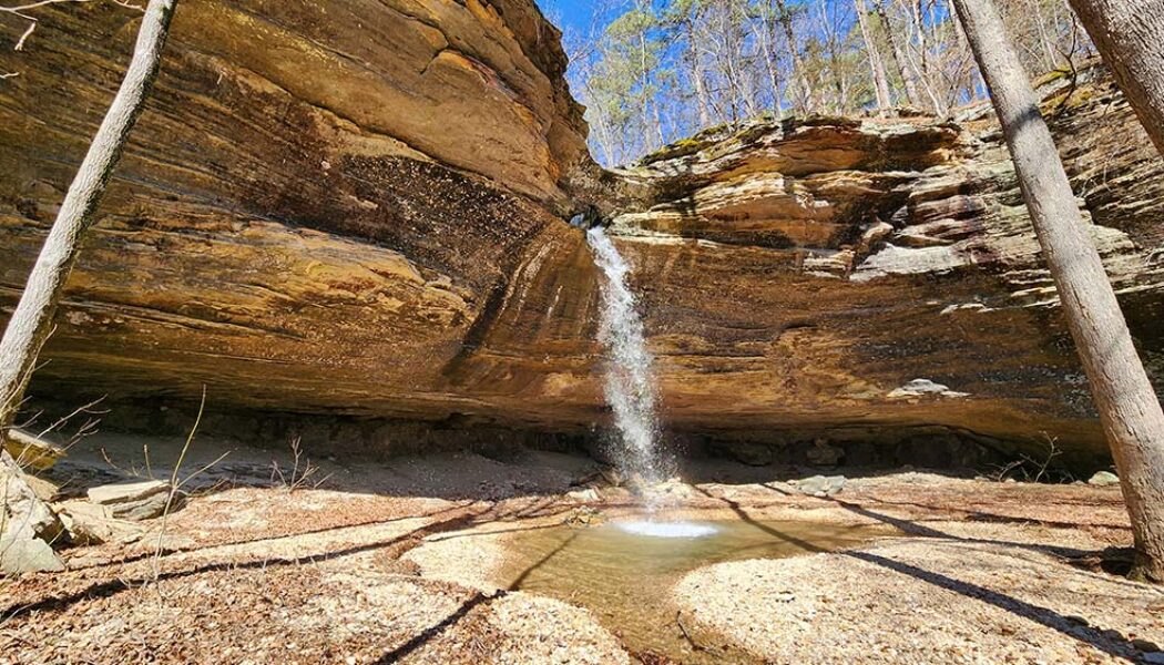

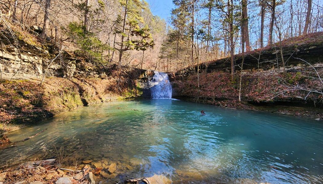
Tea Kettle Falls Hike (with Reynolds Hollow Falls)
Tea Kettle Falls is one of the more well-known and unique waterfalls in Arkansas. The base of the waterfall is a massive grotto style bluff that is quite an impressive sight on it’s own. The creek flowing over the top of the bluff has carved a hole in the rock at the top of it. Much like Glory Hole Falls, the water drops through this hole before ever making it to the edge of the bluff. But where the hole at Glory Hole falls drops straight down through the bluff, Tea Kettle is different. Instead of the hole coming out the bottom, it re-routes horizontally, shooting the water out the side of the bluff. This rock formation resembles the spout of a kettle, which is how Tea Kettle Falls gets its name. I’ve wanted to do the Tea Kettle Falls hike for quite a while, and finally got the...
