
#upperBuffalo

Hike to Hemmed in Hollow from the Compton Trailhead
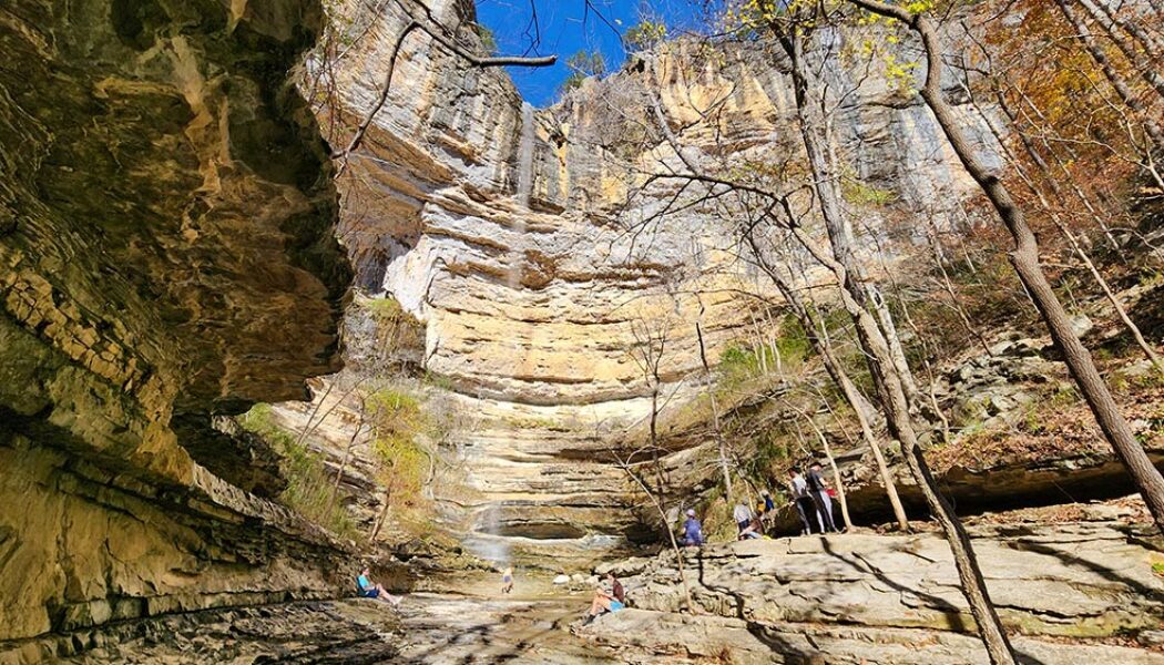
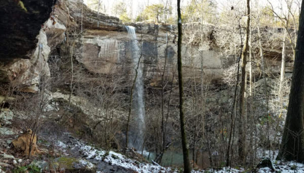
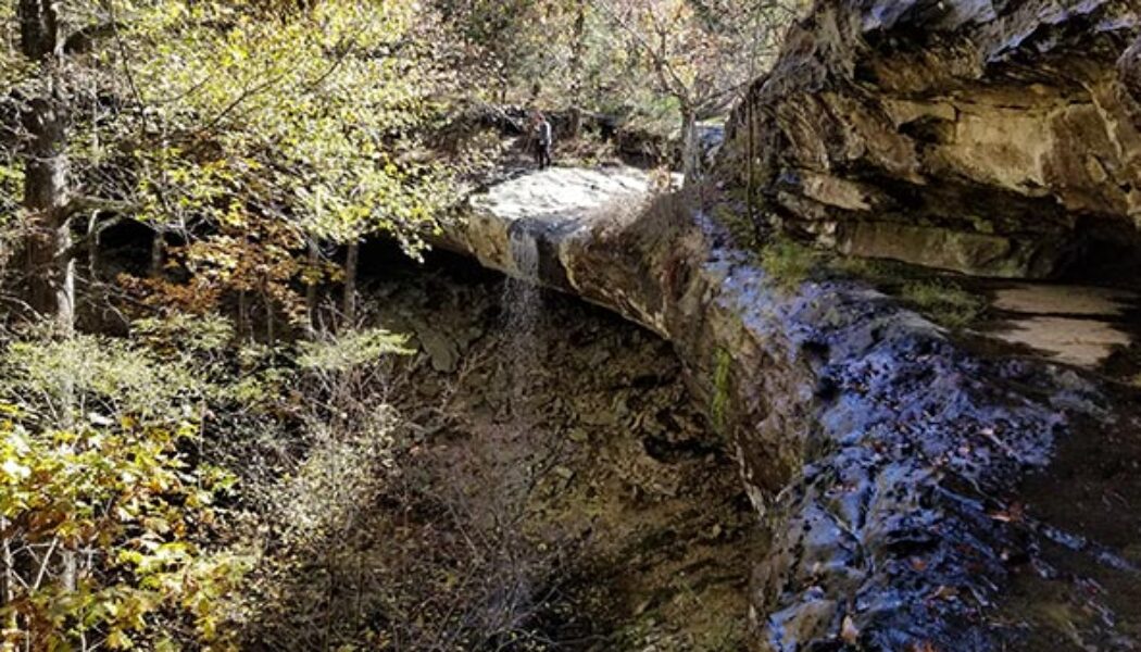
In 2020, I made my first visit to Hemmed-in Hollow Falls. Admittedly, I took the short, easy route by making the quick hike from the Buffalo River while on a float trip. I knew about the popular hike to Hemmed in Hollow from the Compton Trailhead, and had heard it was pretty difficult. So after seeing the impressive sight of the falls crashing down into the hollow, I figured I could check this one off my list. (Seeing the falls is the whole point, right?). But after years of hiking other waterfalls, I felt like I needed this challenging hike on the blog. So I decided to return to Hemmed-in Hollow to do the hike from the top. Hemmed in Hollow Falls, located on the Buffalo National River, is 209 feet tall. That makes it the tallest waterfall in Arkansas. In fact, it’s the tallest water...
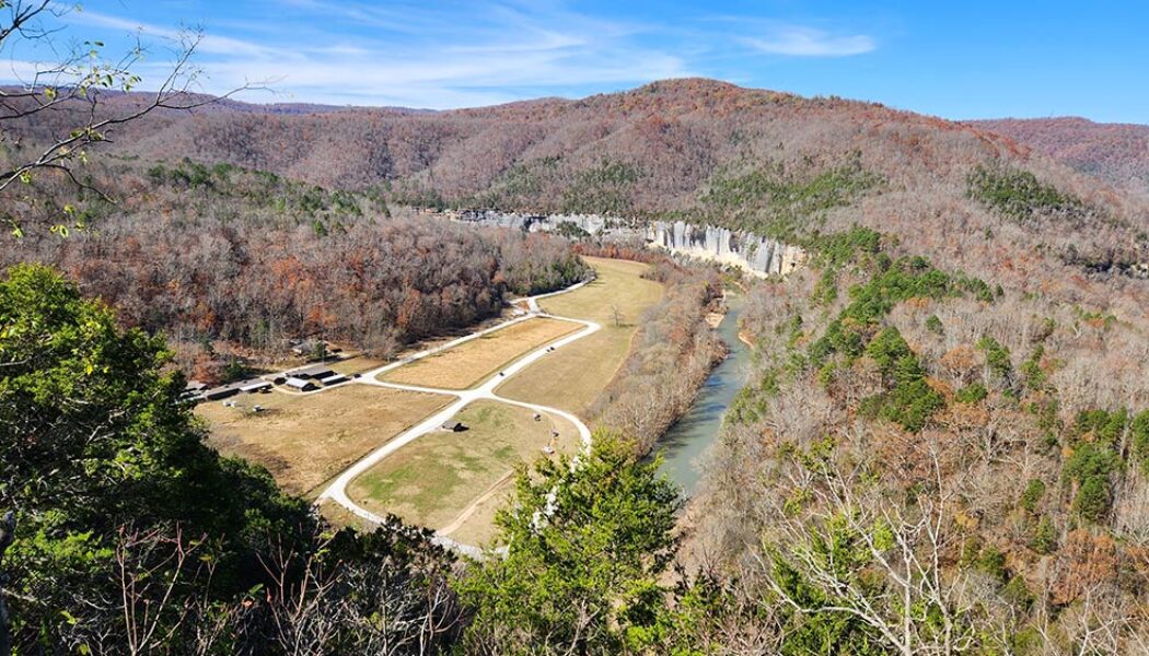

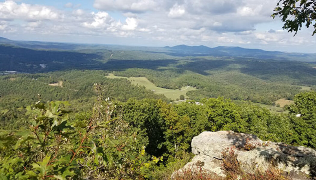
Steel Creek Overlook Hike on the Buffalo River Trail
The Steel Creek Overlook hike is a popular hiking spot along the Buffalo River Trail near Ponca, AR. The Western Section of the Buffalo River Trail (BRT) winds its way along the Upper Buffalo River for 37 miles from Boxley to Pruitt. It offers stunning views of the river, as well as access to a variety of other natural attractions, including waterfalls, caves, and bluffs. Along the way are six different trail heads to access different sections of the BRT. Steel Creek to Kyles Landing is one of these sections. It’s an 8.2-mile hike from Steel Creek to Kyle’s Landing. For many people this might be a bit much, especially for a day hike. But the Steel Creek Overlook hike only involves the first 1.5 miles of this section, and is not that difficult. The rewarding views are definitely...

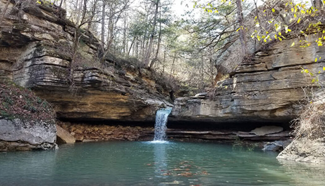
Armadillo Falls and Eden Cave at Lost Valley
Boxley Valley is one of the most iconic areas of the Ozarks. This scenic spot near Ponca attracts thousands of visitors per year to view the elk herds and hike the Upper Buffalo area. And that doesn’t even count the thousands of Buffalo River paddlers each Spring. This area has an abundance of fantastic hiking destinations for hikers to choose from. One of the most popular is an area tucked away in a hollow of Boxley known as Lost Valley. Anyone that has hiked much around the Upper Buffalo has likely hiked to Eden Falls at Lost Valley. But not everyone knows about Armadillo Falls and Eden Cave. The main attractions at Lost Valley are undoubtedly Eden Falls, Cobb Cave, and the Natural Bridge. I’ll admit, the first time I visited Lost Valley, I didn’t know there was anythin...

Compton’s Double Falls and Amber Falls
*In Memory of Rick Henry.* Rick, you may not have known most of your readers, but we feel like we knew you. Thank you for leading us to so many beautiful places. When it comes to waterfall hiking, it’s always great to get your money’s worth with multiple falls on a single hike. Most of the waterfall hikes in the Ozarks offer this opportunity, although some make it easier than others. My recent Christmas hike to Compton’s Double Falls and Amber Falls is a great example. Much like the Magnolia Falls hike, this one has several falls, each one just around the bend from the next. As long as there is water, you get to see five waterfalls on this hike. And you can continue down Whitaker Creek to see several more (Wild Burro, Beagle Point, and other smaller falls). This is a...


Hike to Thunder Canyon Falls
Waterfall season got a late start this year, but it is finally underway. I have been on a roll lately, checking hikes off my list that have been tugging at me for years. And once the steady rains hit the Natural State, I got to start checking off some more. At the top of my list this waterfall season was the Hike to Thunder Canyon Falls. I actually tried to do this one last Winter. But I had not done my homework and was unprepared for creek crossings, or even reaching the trailhead. Since then I’ve had trouble getting back there after the right amount of rain. That is until December, 2021. When the rains finally hit, I was ready for this one. I enjoy all of the waterfalls that I hike to. But there is something different about Thunder Canyon. To me, there’s a certain mystique ab...

Round Top Mountain Hiking Trails
There are many hikes in Arkansas that are better at certain times than others. And when you can’t do those, you need a backup plan. I have a list of hikes that I have been saving for times when rivers and waterfalls are dry. These are my “Plan B” hikes. Not because they are not good hikes, but because they can be done at any time. Hikes like Centerpoint/Goat Trail to Big Bluff or the Mt. Nebo Rim Trail for example. The latest Plan B hike I’ve checked off my list was a visit to Round Top Mountain hiking trails. I have passed by Round Top Mountain dozens of times on my way to Jasper or the Upper Buffalo River area. This Fall I finally had a good chance to stop in and hike it. I had been out waterfall hunting up Hwy 7 right after a rain. And after striking out on...
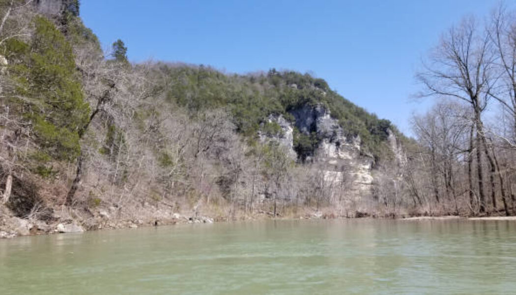

Floating Kyle’s Landing to Ozark on the Buffalo River
Spring is here and it’s time to float the upper portion of your favorite rivers. This year, my first float trip was Kyle’s Landing to Ozark on the Buffalo River. I usually make it a point to float Ponca to Kyle’s Landing every year. But I’m on a mission to float all the sections of the Buffalo I haven’t done yet, along with some new rivers. So floating this section on the Upper Buffalo was a top priority. It will likely be too low to float by mid-June, so you’ve got to get it while you can! We had a perfect Saturday for floating the last weekend of March. The area had gotten some good rain that week and the river was really high that Friday. But the Upper Buffalo drains off quickly, and by Saturday the water level was just right. Combine that with a sunn...

Sweden Creek Falls Hike in the Ozarks
For my first hike of the year I continued on my quest to hike all the major waterfalls in the Upper Buffalo River area. I decided to start the year off with the Sweden Creek Falls hike since it had been on my list for a while. And the conditions were perfect for a waterfall hike that day. The Kingston area had gotten some rain for several days before, and even some snow. On the day of my hike, the sun was out in full to warm things up to the mid-40’s. This meant there should be plenty of water in the falls from the snow-melt and previous rain. Full sun and water in the falls? I couldn’t ask for better conditions, especially for this hike. Driving up Hwy 21 from Clarksville to Boxley, I was pleased to see there was still a light dusting of snow on the ground. I haven’t see...

Paige Falls and Broadwater Hollow Falls
I have written a few articles lately about hiking around the Upper Buffalo River. That’s because there are so many great places there to hike. And most of them are not that far from each other, so it’s easy to do several in a day. All the trails have something different to offer. Some of them have waterfalls, others have majestic views, and some have caves and weird rock formations. They range from easy to difficult, short to long. And some of them are barely a hike at all. Paige Falls and Broadwater Hallow Falls is one of those. Much like Six Finger Falls and Fuzzy Butt Falls, it’s really hard to call this one a hike because the falls are so close to the road. The hike may be really short, but that doesn’t make the waterfalls here less impressive. In fact, this is ...

Hike to Hideout Hollow
As much as I hate for summer to end, there is a silver lining to Fall and cooler weather getting here. It’s my favorite time of the year to go hiking, for so many reasons. Overgrown trails become more clean. Ticks, chiggers and snakes go away. I can hike all day without sweating my ass off. The fall colors make the drive and the hike even more scenic. And late Fall means more rain, which means the waterfalls are running! This Fall I picked the perfect day to make the hike to Hideout Hollow. Hideout Hollow is a huge grotto/gorge (a hollow) encased in steep bluff walls with a 40 foot waterfall in the middle. Beneath the cliffs you can find the remains of an old “hideout” structure used by outlaws years ago. Hence the name “Hideout Hollow”. Stories vary on who th...
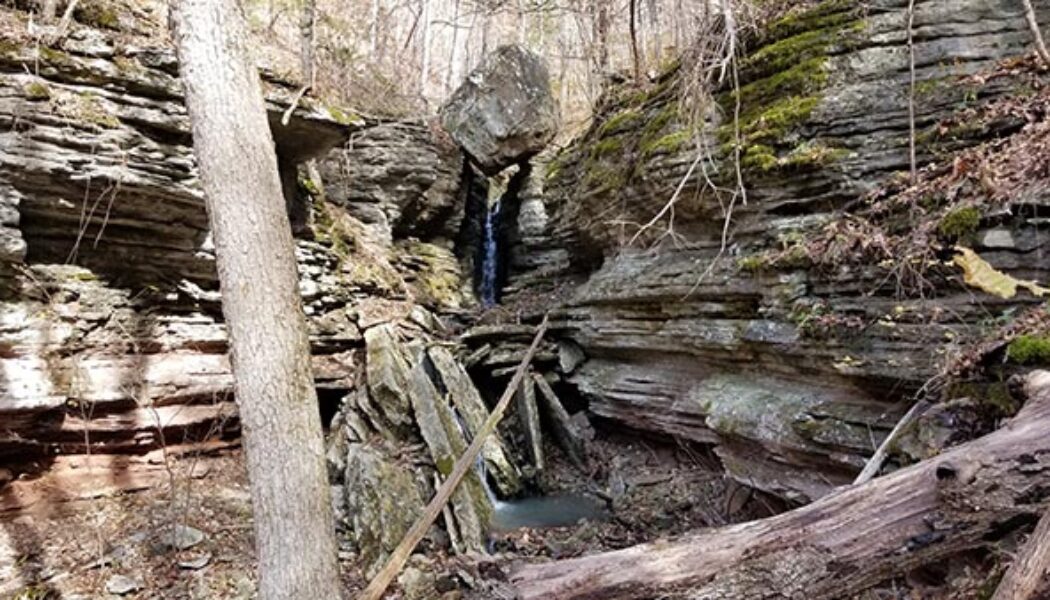

Hike to Balanced Rock Falls
The Buffalo River is well-known as probably the most popular floating and paddling river in Arkansas. But the lands around it are home to some of the best hiking spots in the state. In particular the Upper Buffalo area near Ponca, Boxley Valley and Compton is where you’ll find a lot of the most popular trails. There is a lesser-known hike in this area that is worth a look and that is the hike to Balanced Rock Falls. You won’t find the trailhead for this one on Google maps like the other ones. Nor is it listed on the Buffalo River NPS hiking page or the Hiking Project App. But you can find it on the AllTrails app I found this hike when I saw pictures of Balanced Rock Falls posted on some of the Facebook hiking pages that I follow. I like interesting rock formations as much as I ...
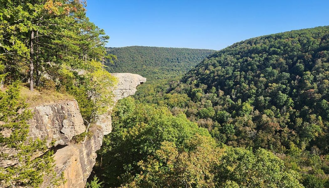

Hike to Whitaker Point(Hawksbill Crag)
If you do a lot of hiking in Arkansas and haven’t made the hike to Whitaker Point, you have to add this one to your to-do list. It’s one of the more popular hikes in the Ozarks. Even if you don’t know what Whitaker Point is, you’ve probably seen a picture of it somewhere. Also known as Hawksbill Crag, it is one of the most photographed scenic spots in Arkansas. Lots of marriage proposals happen here and people actually pay photographers to capture the moment from far off. So what is it? Hawksbill Crag is a large rock outcropping sticking out from the top of a really high bluff. The bluff overlooks Whitaker creek in the valley below. On the AllTrails app, it is listed as “Whitaker Point Trail (Hawksbill Crag)”. On Google maps, you’ll find both ̶...
- 1
- 2
